


4.0 Spili- Gerakari- Moni Arkadiou- Anogia | 78 km | 2.006 vertial meter | Category 2
78 km | 2.006 vertical meters | Category 2
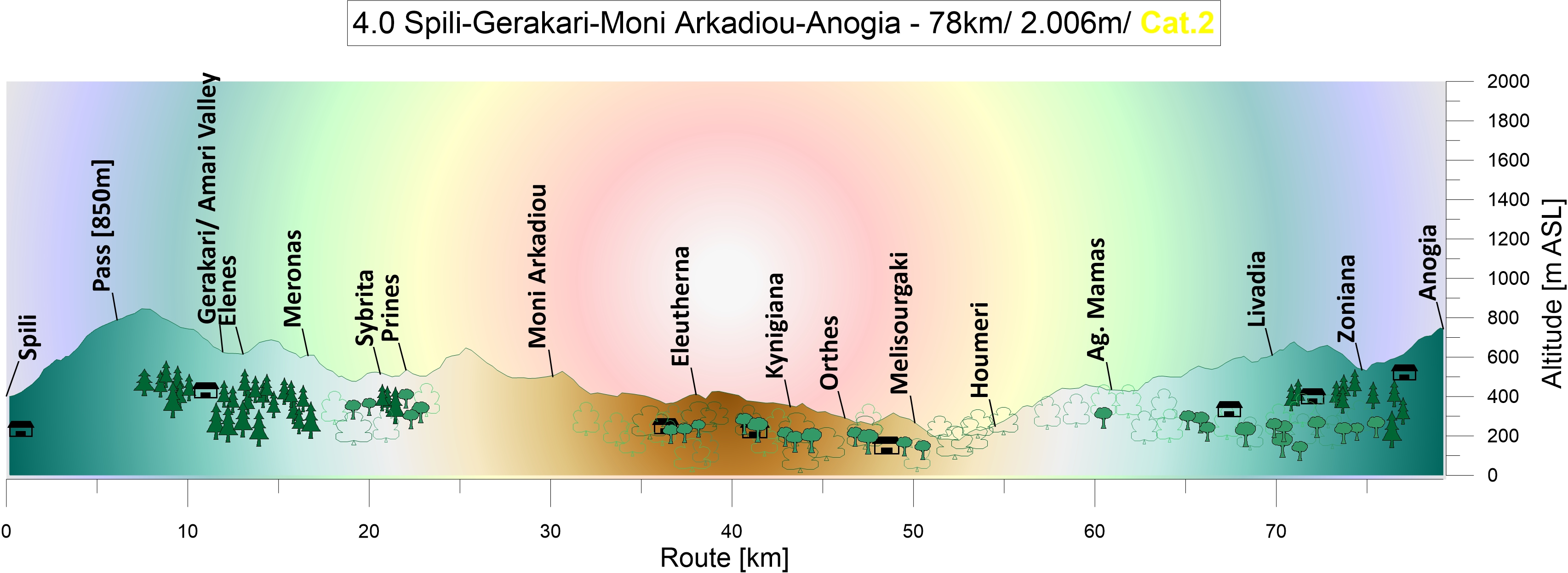
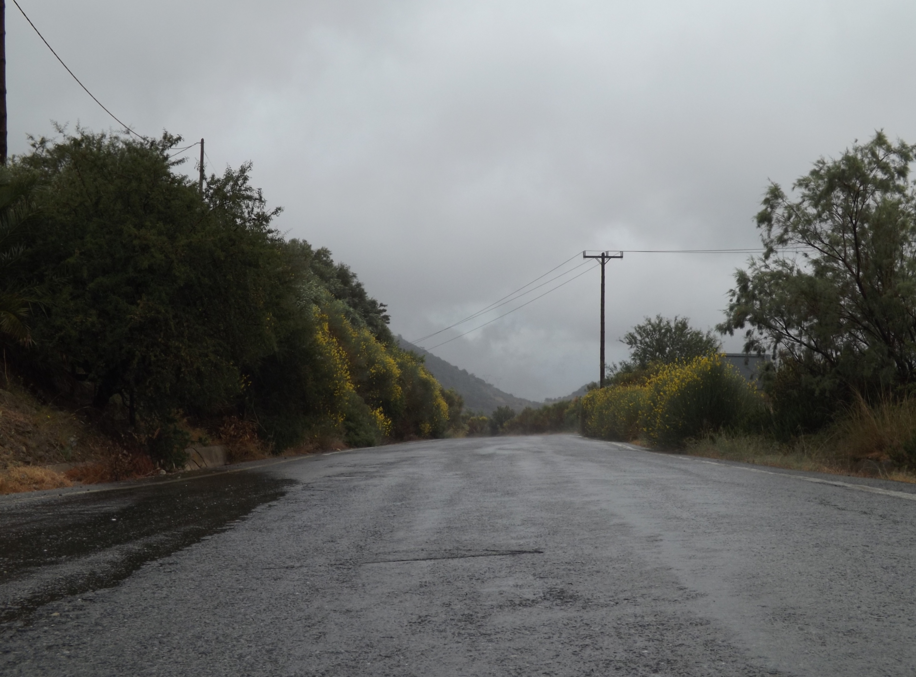
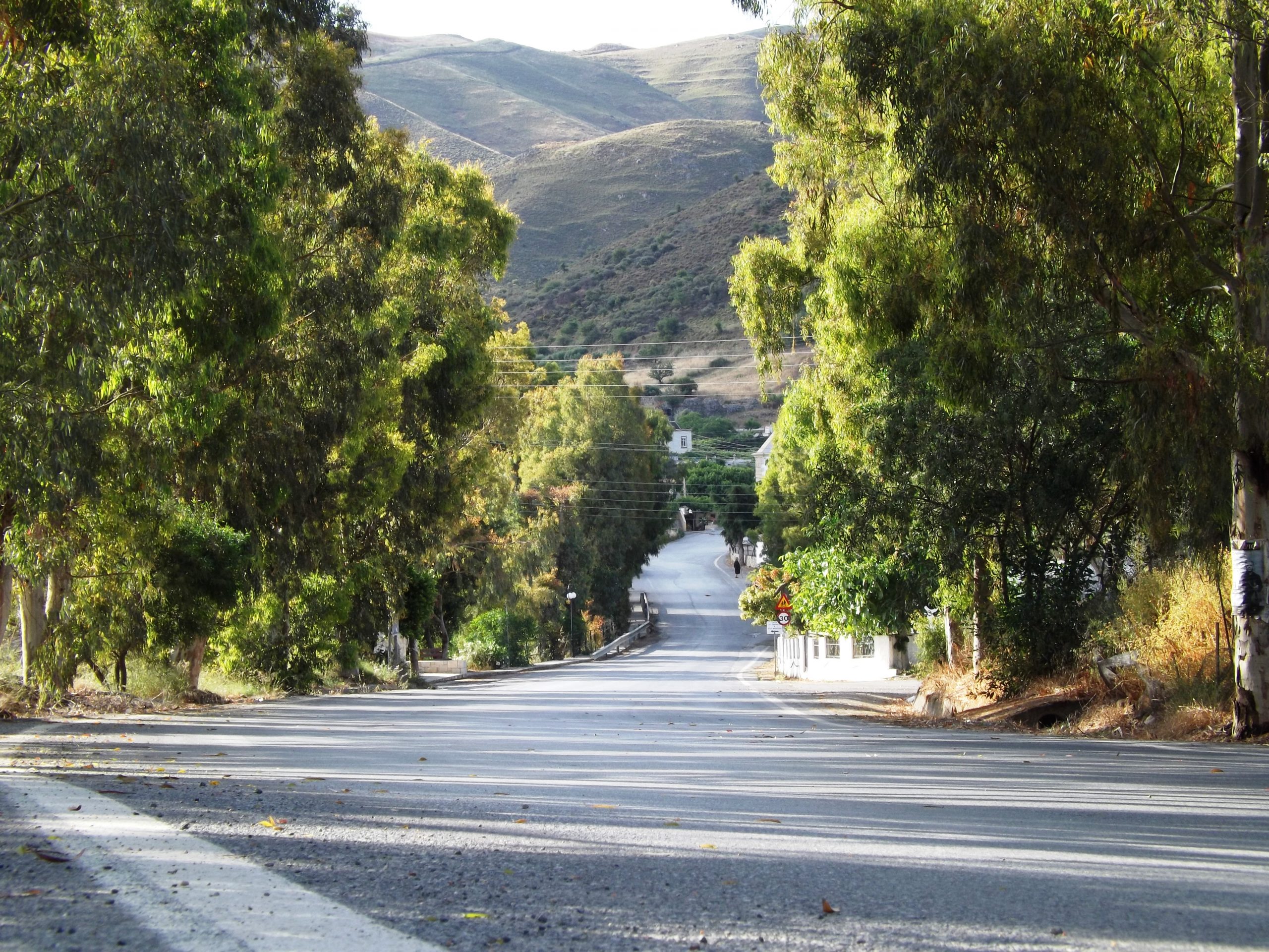
From Spili to the Amary valley: While the first rays of the sun illuminate Mount Kedros (1.776m), the climber faces a steep ascent to the mountain ridge at 850m, high above the Amari Valley. Leaving Spili at its western outskirts, the road winds upwards, giving beautiful views of the village and the green valley – all the way to the horizon and Mt. Sideronas (1.177m) in the south.
The road cuts into the hillside with exposed platy limestone. The gradient is often 15% and even greater at some stages. After five kilometers of strenuous climbing, a plateau opens up. It’s a small basin filled with sandstones and conglomerates of the Tertiary Flysch. Wide fields light up the way in green and yellow, intersected by the fading lines of grey limestone walls. A white spot, the chapel of Ag. Ioannis, flashes through the trees.
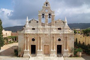
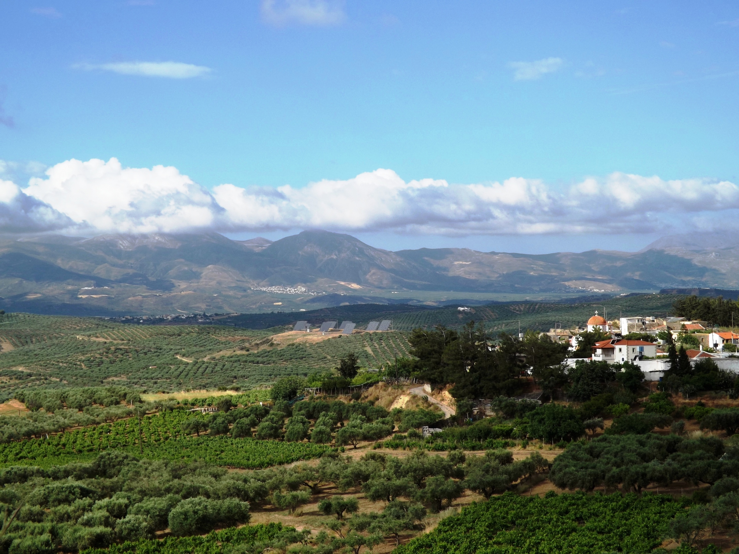
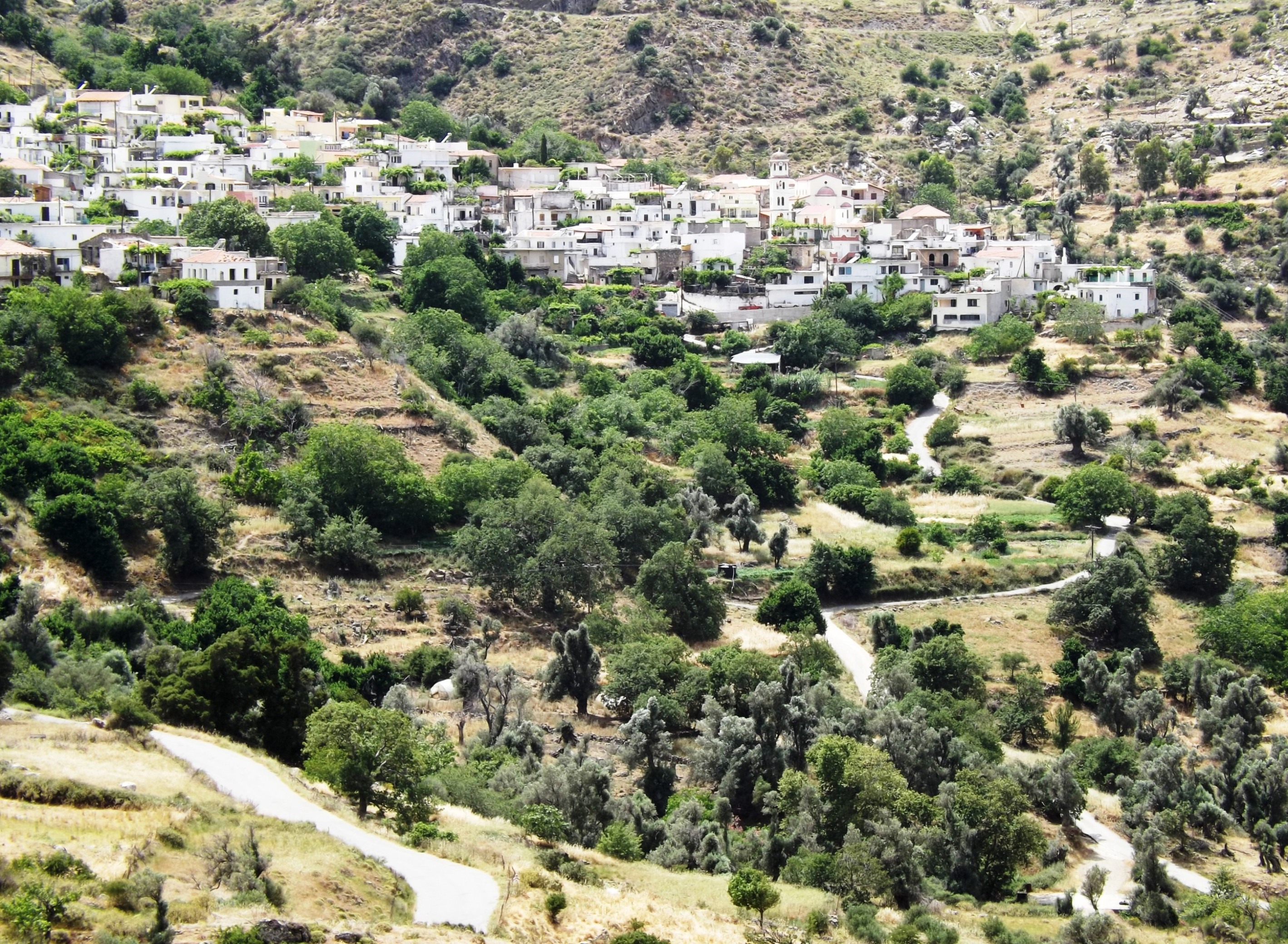
Amari valley: Soon after, the mountain village of Geraki comes into view, embedded in an Alpine landscape with green meadows, oaks and firs. You can look deep into the fertile valley of Amari with its alluvial plane tree forest until you pass the acropolis of ancient Sybrita. Leaving these green slopes behind, you climb through a wild landscape of rugged mountains until you reach the Monastery of Arkadi in the north.
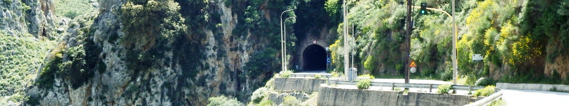
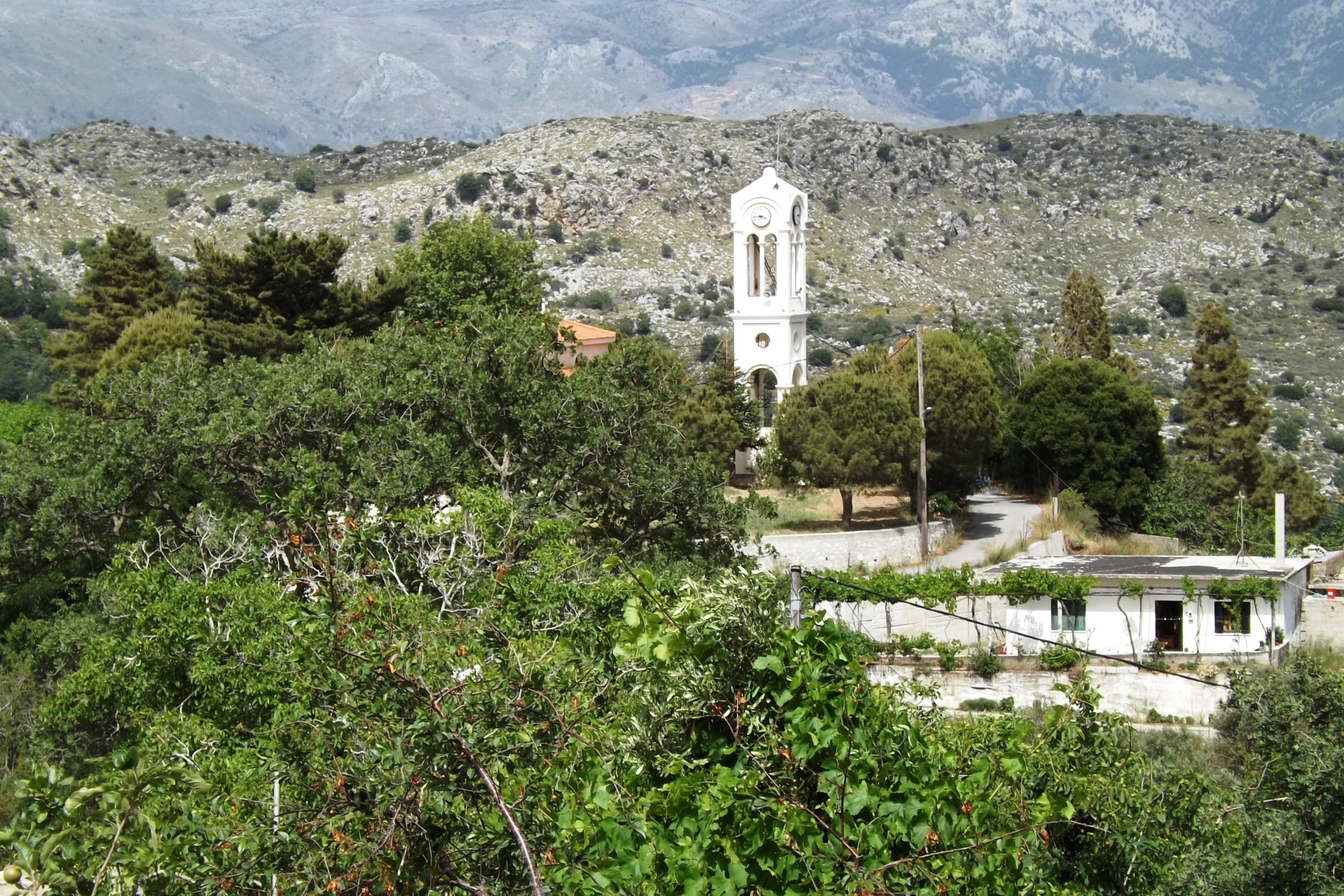
Following the slopes of Mount Ida to the east, you pass ancient Eleftherna while going further downhill to the lowest point of the route near Perama. From here, there are 570 meters to climb until you reach Anogia. At the picturesque Platia Meintani, there are restaurants and cafes located under large sycamores, facing the church of Agios Georgios – a perfect place for a break.

I pause at the Kafeonion under the large village sycamore tree and enjoy vegetable soup and lamb chops, while the old folks frown at me and mumble their comments with raised eyebrows until we start drinking raki together.
Later on, on my way home, I cannot walk in a straight line thanks to the strong liquor, and my feet can hardly manage the ascent. But for the first time ever, the village youngsters greet me with respect, and their eyes seem to ask: »Where are your sheep?«

4.1 Spili- Gerakari- Zaros- Lendas | 109 km | 2.104 vertical meters | Hors Categorie
109 km | 2.104 vertical meters | Hors Categorie
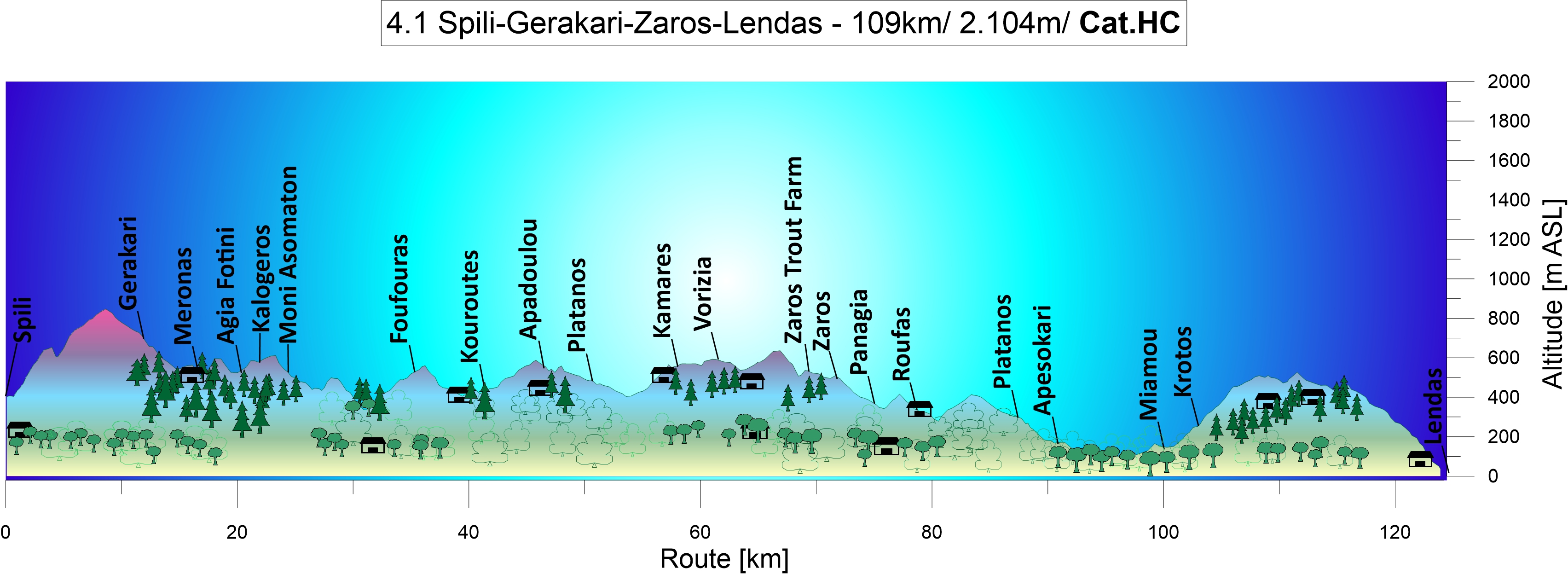
From Spili to the Amary valley: Coming from Thronos, you’ll go downhill past green farmland until you reach Asomatos Abbey. Take a short break to enjoy the silence of a spring day and listen to the water dripping and gurgling in the brooks that run through this lavishly green, moist valley. You will also see the snow-covered peaks of the Ida mountain rise up in the north.

The fertile Amari basin is located between the Levka Ori “White Mountains“ and the Idi Ori mountains. It is sheltered by the mountain ranges of Mount Sidherondas (1.177m) that stretch from the north-west to the south-east, as well as by Mount Kedros (1.776m), Mount Soros (1.184m) and Mount Samitos (1.100m), while Mount Katsonichis (1091m) and Mount Veni Korifi (740m) provide protection in the west.
The peak of Crete’s highest mountain, Mount Psiloritis (2456m), towers above them all. Unlike Mount Idi Ori and Mount Psiloritis, all these mountains consist of Mesozoic lithographic limestone. Small basins filled with sandstone and conglomerates of Tertiary flysch are dotted all around. Ride along the flanks of Mount Oros Idi to Zaros.

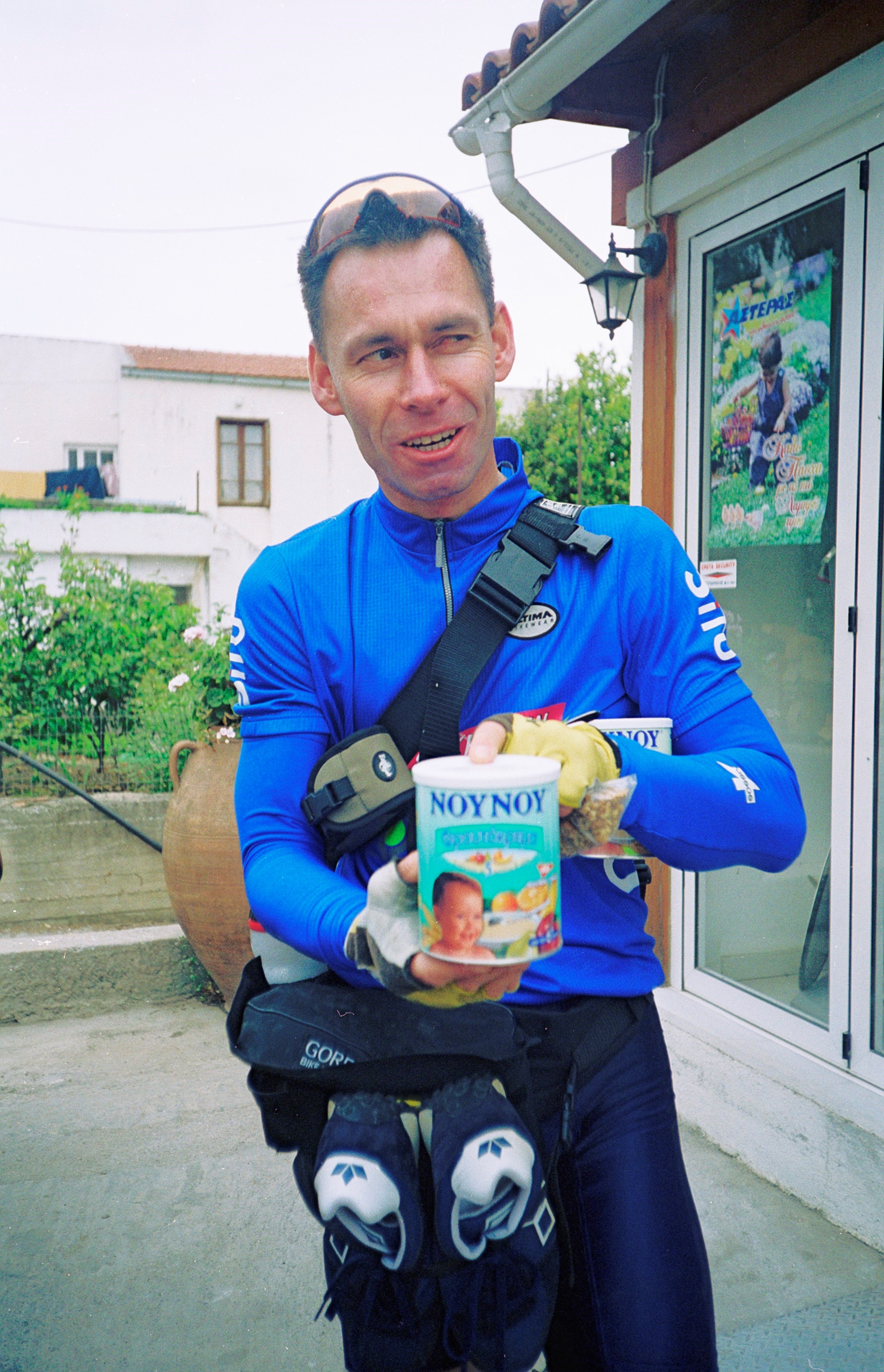
Zaros: Here you find Crete’s one and only trout farm, located in short distance above the town. There are several restaurants for a bite to eat and a hotel. In the shade of a cherry tree near the ponds, the rustling leaves lulled us to sleep. We dreamed of a hearty meal and were awakened by delicious scents.
The feast: After five hours on our bikes and two litres of thinned baby rice as our only food, because we had run out of the all-important mixture of apple juice and diluted porridge oats, we feasted on Greek salad, bread and smoked trout, and we each drank half a litre of red wine. We still had 40kms left to ride and an altitude difference of 600m to manage before we reached the southern coast at Lendas. And therefore a piece of advice for you readers: never eat smoked trout on mountain rides! We had never felt so sick riding uphill. We had no energy left to ride and each turn of the wheel seemed to bring us closer to giving up and collapse than to reaching our destination.
Down on our knees: It was a nasty struggle against never-ending pain and agony. The dusk mercifully lent the cover of darkness to the pathetic moment when the two of us were down on our knees by the roadside. We did finally reach the pass in the end and dashed down towards the moonlit ocean, catching our breath again.
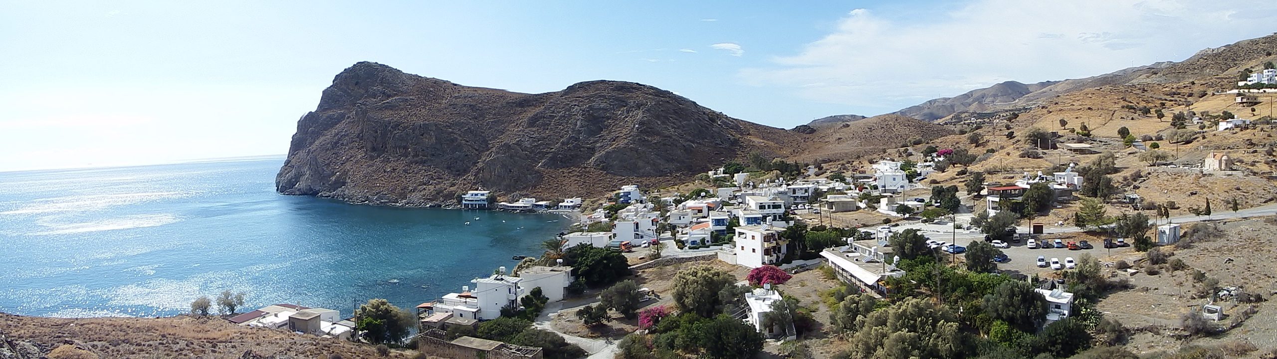
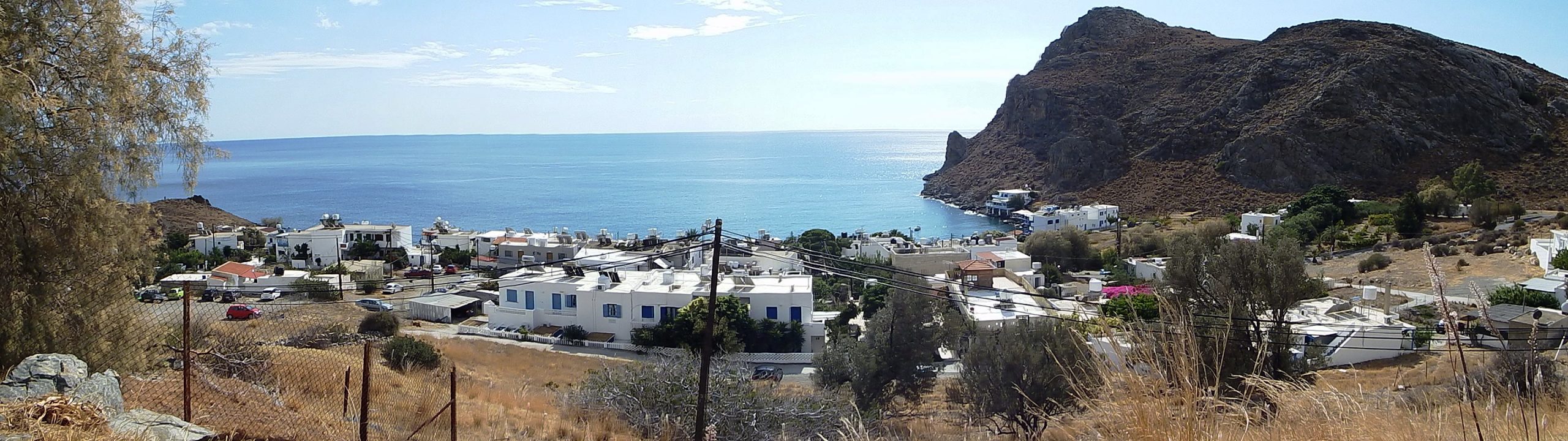
It felt like paradise when we arrived in Lendas, but the night had another ordeal in store for us: our intention was to travel light, which meant we had not brought our mosquito nets with us!
Asterousia mountains: On your way to the southern coast, you will pass the Asterousia mountains located south of and alongside the Messara plain which stretch from the west to the east. Ranging from Kap Lithino via Kali Limenis, Lendas and Kapetaniana to Tsoutsouros and Agioa Ioanis, the mountain chain is more than 50km long and reaches an altitude of 1.230m at Mount Kofinas.
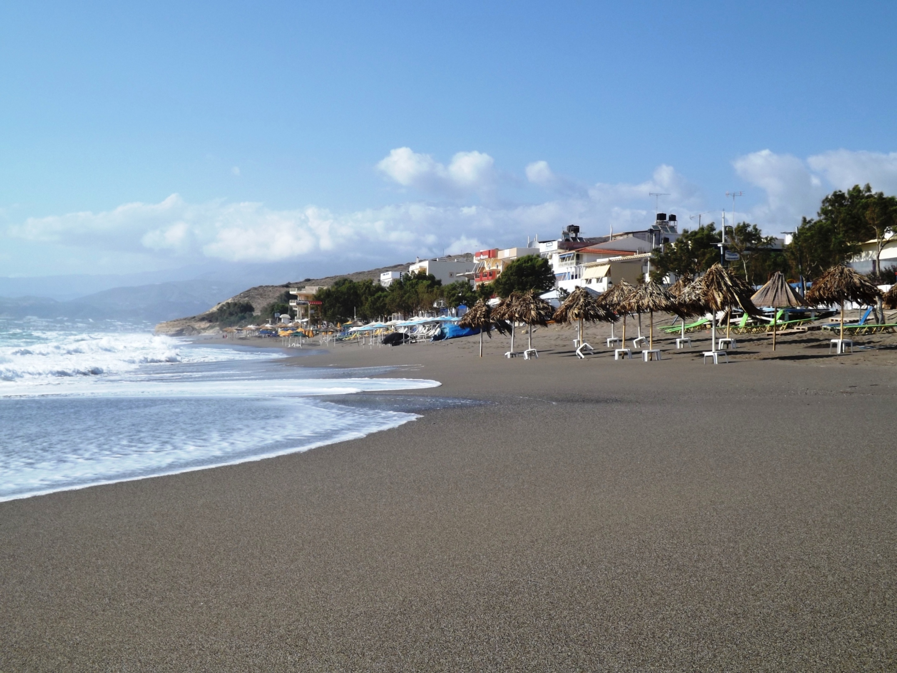
Descent to Lendas: The road leading out of the Messara plain and over the mountains at Miamou and Krotos to Lendas is one of the most beautiful routes you can ride. From the pass, the road bends and rises up again to the opposite flank. You should try to conquer this in a sprint. The road will then suddenly reveal views of the wide ocean gleaming in the depth.
With your body bent over the handlebars, you glide downhill towards the water, taking turn after turn like a bird while the steep rock slope reveal nothing, not even the coast or a house. The town only comes into sight once you reach the last downward stretch near the dunes.

The geology of the mountains is very interesting. On the road leading down to the coast from Krotos to Lendas, you can see various forms of worn away metamorphic rocks, including amphibolite, quartzite, gneiss, sillimanite, granite schist, and mica slate. You can even spot ophiolites on the outskirts of Krotos and escarped granite intrusions along the track leading from Lendas to Kali Limenes. Lithographic limestone of the Tripoltiza unit forms the base of the massif. You will see it in the west, the south-east and at the southern coast. Palaeocene and Eocene flysch sediments with limestone and serpentine inlays follow towards the north. The region between Kali Limenis in the west and Lendas is characterised by a zone of distinctive metamorphosis with gneiss formation.

5.0 Anogia- Tilisos- Gergeri- Lendas | 101 km | 2.295 vertical meters | Hors Categorie
101 km | 2.295 vertical meters | Hors Categorie

Aristea pushes me vigorously in her living room. The breakfast table is set for the guests. The ancestors look down seriously from the photos on the wall, while politicians fight on TV. The coffee comes in the Briki on the stove and on the table is a hissing gas burner, to cook my breakfast egg simultaneously. I hope that the house will not burn down.
From Anogia to Lendas: After the days in the magnificent mountain scenery around Anogia, the tour leads down from the pastures of Nida, through the wine region east of Psiloritis, through the Messara and across the Asterousia mountains to the south coast at Lendas. A short climb to the pass, then I was rushing down quickly in the direction of Iraklion, through the picturesque villages Avdou and Gonies; white colored spots dotted into the landscape.

Four kilometers behind Gonies, is on the right side of the road on a slope, the Late Minoan mansion of Sclavokambos. Magazines and utility rooms are arranged around a large courtyard. There are finds of clay sealings and household activities.
The road continues through the Gonies gorge at dizzying heights towards Tilisos. Here three Late Minoan villas are located above the center, overlooking the rolling countryside east of Psiloritis, with olives and wine.
In the village, it is not so easy to find the right way heading south. At the EATA postoffice turn right, then slightly uphill and agian half right at the first junction. Then go straight on until you reach the main square with the church and the fountion on the right. Here turn left and and at the next option to the right, then downhill again. From the village exit follow the road until you reach the small bridge over the brook in the valley. Crossing the creek and following the S-curve you reach Keramoutsi after about 150 meters.
Via Keramoutsi I continued to Krousonas, and here things got complicated.

A growling and slobbering monster: After the Krousonas Platia and the church, I turned right and in southern direction towards Kato Asites. One kilometer further, I was shocked by a large dog. From a doorway, it rushed towards me at high speed and was fortunately pulled back abruptly from a long chain. At this growling, slobbering and perhaps biting monster, there was no way to pass. It was pure adrenaline that flooded my body.

The third time is the charm: Now I turned to Plan B. Just the other way round, I turned in eastern direction for the road via Kitarida, Agia Mironas and Pirgou. But after a while I was wondering, because I went constantly to the north, Iraklion nearby in sight, and I felt, that with every pedal stroke the distance to my destination was always getting greater. And when I saw Iraklion and the sea quite close beneath me at a junction, I was sure that I had lost my way. I had no idea, that at this point, the road to Agia Mironas makes a wide arc to the north. Without getting any closer to my destination, I had been forced back two times, but the third time is the charm.
Sarchos: After a short rest, my nerves calmed down. Heroic I broke the front at Sarchos and got lucky to Kato Asites. It’s a beautiful track on unpaved road through a small valley and up to the village. Once you’ve managed to follow the winding streets through the center of Sarchos to the south, turn left at the y- junction 500 meters after the village exit. Here you have to ford a shallow brook. It’s a perfect place to rest in the shade under rustling plane and oak trees with spots of bugleweed, horsetail and oleander.
From Agia Varvara to the Messara plain: You will admire the fantastic mountain scenery, as the road winds over the pass at Agia Varvara and down to Gergeri. From here you’ll have a wide view over the Messara plain, to the Messara bay to the west and the Lassithi Mountains to the east. And far to the south lies the elongated mountain range of the Asterousia Mountains, a big obstacle in front of the Libyan Sea, which must be overcome if you want to reach Lendas and the south coast.

A fast downhill to the Messara near Gortyn, with the Doric ruins from 500 BC. And you’ll pass through corn fields via Mitropolis, along olive groves and vineyards, crossing the Mitropolianos and Jeropotamos River, pass through Platanos and ride until you reach Plora and Apesokari, situated at the northern foot of the Asterousia mounts.
Asterousia mounts: First the road winds up the mountain slopes in steep and narrow bends, while the Messara lies deep down in the shimmering heat. Later, after approximate five kilometers, the slope decreases.

When you reach the village Miamou at 480m, there is only a last mountain ridge to conquer. Then there are ten kilometers of the most beautiful roads in Europe ahead of you.
Descent to Lendas: Enjoy the acceleration on the straight, hit the brakes before the curve, look ahead to the inner curve and dive down on the serpentine road. Remember, though, that there is oncoming traffic. While you race the last switchbacks you see the white polka dots at the edge of the deep blue ocean; the houses of Lendas. Go for the adventure!


5.1 Anogia- Nida- Gergeri- Lendas | 84 km | 2.384 vertical meters | Hors Categorie
84 km | 2.384 vertical meters | Hors Categorie
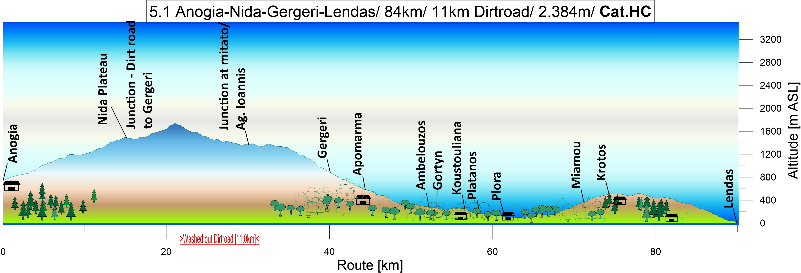
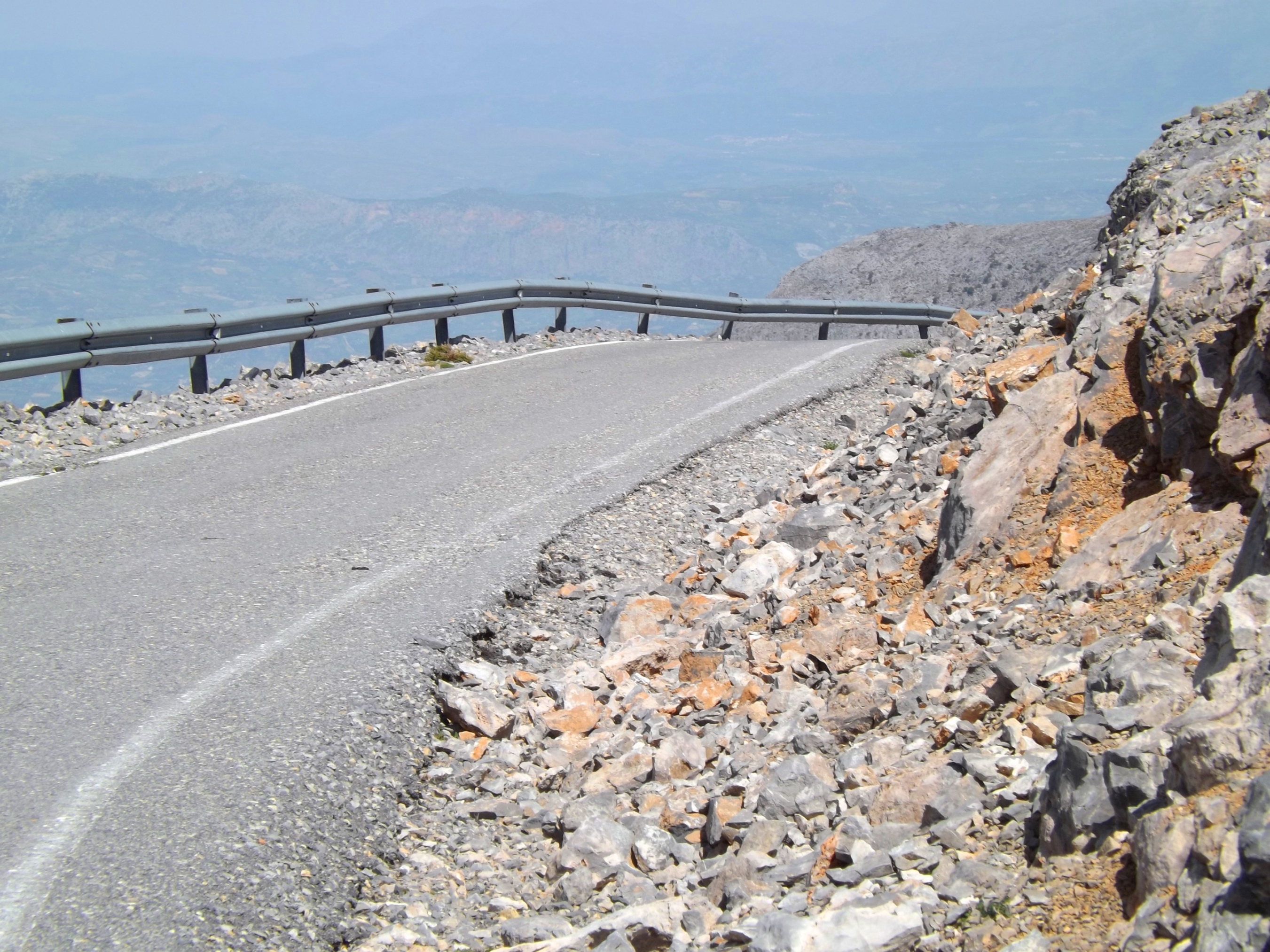
From Anogia via Nida plateau to Lendas: From Anogia at 800m, you climb up into the Oros Idi Mountains, the centralmassif of Crete with Mount Psiloritis (2.456m). The road leads past the outcrops of Permian limestone, the overlying crystalline limestones, and the intercalated crystalline schist-clay deposits of the most recent mountain uplift. The higher you go, the softer the outlines become and increasingly shaped by the Karst.

The road is steep with just a few green leaves and green spots by the roadside. The vegetation is so dry that the few shrubs and cypress trees around are withering away. It is hard work to reach the pass at 1500m in the summertime, but once you get there the mountain ridge boasts splendid views of the Nida plateau, and the green meadows of mountain grass form a bright contrast to the grey surrounding rock.
Mount Skinakas: The destination we are trying to reach is a fantastic lunar landscape, the Karst desert of Mount Skinakas at 1750m. There is an observatory owned by the Greek University and the Max Plank Society at the top.
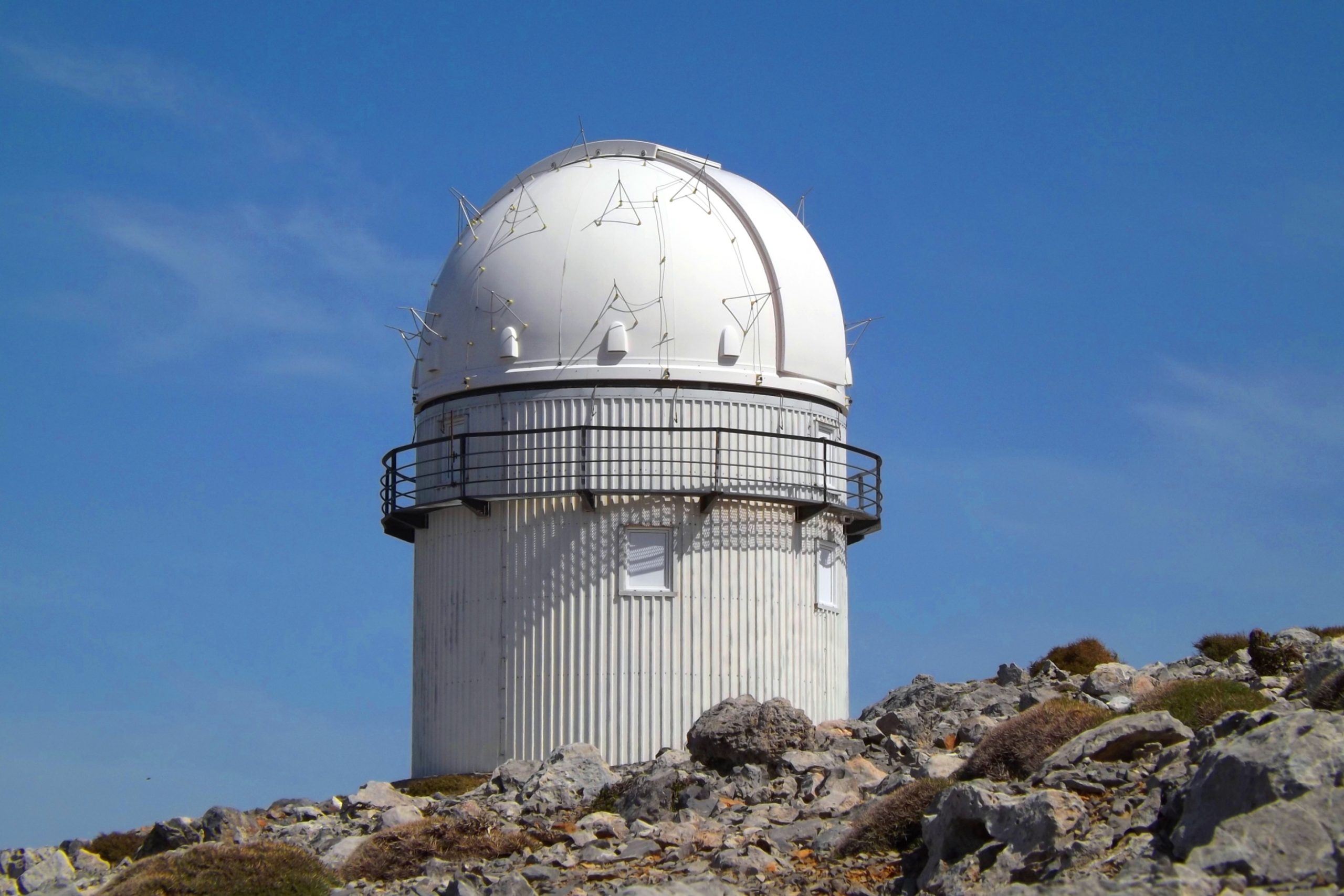
If the sky is clear, you can enjoy perfect views of the Nida plateau and the twin peaks of Mount Psiloritis. In a southeasterly direction with the Rouvas forest, we overlook the wide plain of the Messara up to the next destination at the horizon, the Asterousia Mountains. The location truly makes you feel close to God.

Two and a half kilometers short of the observatory, a 11km washed-out dirt road and another ten kilometers on asphalt lead to the village of Gergeri and then further to the south coast.
If you travel on a racing bike it’s advisable to equip them with cross tires. Off-road biking techniques are definitely required here.
The Broken Spoke: Nevertheless, while riding through a scree field on the way to Gergeri, still on the asphalted section below Mount Skinakas, a stone hit the rim so unfortunately that a spoke of the front tire broke.

Stuck alongside my air pump were my spare spokes – never used before – and one of them was now to be mounted. With the last Mavic wheelset I used, you didn’t even have to dismantle the inner tube and tire. The spoke was simply hooked into the nave and the spoke nipple was turned into the rim from the outside.
Now, could there possibly be a more fascinating pastime than to figure out how the new Campagnolo wheelset is supposed to work while you are on a road to nowhere in the solitude of the mountains, surrounded by inquisitive sheep and with fog rising up from the valley?
The spoke was broken just below the spoke nipple, so the old nipple had to come out first. This was easier than expected as it simply slid backwards and disappeared into the closed hollow section rim – and from there, the only exit is the hole of the valve holder.
During the disassembly of tire and inner tube you will already have a sense of foreboding, because the new nipple has to return to its position in the same way. In order to manage this, there is a specific magnetic screw, and its sole purpose it to be screwed into the nipple, so that you can push it to its position inside the rim with a magnet from the outside.
At a children’s birthday party, this kind of mechanical puzzle where they have to balance mice into a mousetrap, balls into a soccer goal or even land rockets on the moon may be a highlight. But in my case it was not just a waste of time but a waste of waste – so I had better get to work!

A quick geological mineral prospection in the surrounding area did not reveal the faintest presence of magnetite. So the counter bearing of the future spoke was cheerfully jingling back and forth inside the rim, sometimes completely silencing, as if it wanted to hide from me, then again stubbornly denying his whereabouts with a distorted voice.
In the spirit of modern, minimally invasive microsurgery, I tried to get hold of it with a thin screwdriver which I inserted through the small opening of the nipple holder. We live in the 21th century, we can overcome the gravity field of our planet, and even small children can explain quantum mechanics to their stupid parents. So after a lot of turning, fiddling and cursing I eventually managed to move the nipple to its place. I have to confess that, to do so, I took the inside of the rim into my mouth and sucked! (For the zoologically interested reader: walruses do the same.)

Never before has a small piece of metal been held so intimately, been cared for so much or been beseeched with such kind words as on this foggy day below Mount Skinakas. The rest is child’s play, because once nipple and spoke have found each other, you only have to open the cover of the nave which is held by two screws, hook in the new spoke, and – voilá! – mount the inner tube and tire.
Out of humility, my bike and I walked the next 10 kilometers until the condition of the track improved. Fortunately, I soon had asphalt under my tires again.

Asterousia Mountains – Descent to Lendas: Crossing the Messara plain at Gortyn, you’ll soon reach the foot of the Asterousia Mountains. There are 400 vertical meters to climb on twisting roads up to the mountain ridge.
The track down to the sea is one of the finest on this route. In long sweeping bends, your body hunched over the handlebars, you will rush down into the depths and dive headlong into the Big Blue.
There is nothing but the dark ribbon of the road, no indication of any houses, a village or people below these steep slopes.
The last downturn, close to the dunes, finally reveals the village of Lendas. Go for the adventure!

5.2 Anogia- Mount Skinakas- Nida- Ski Resort- Anogia | 57 km | 1.780 vertical meters | Category 3
57 km | 1.780 vertical meters | Category 3
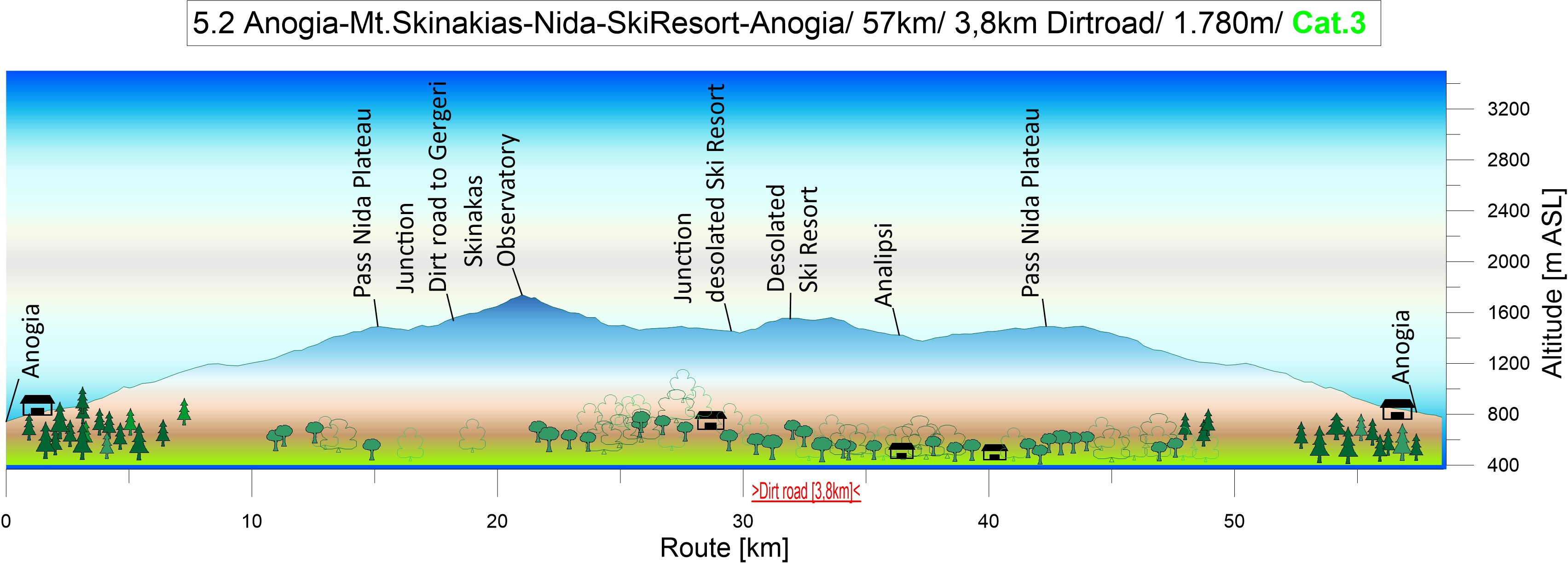
Exploring the Nida plateau: Have a fun and challenging ride while exploring the Nida plateau and the surrounding area.
Leaving the lively atmosphere of Anogia, going higher into the Crete Mountains, 1.000 meters up on the north face of Mount Psiloritis. After 15km of strenuous climbing turn left at the junction to the Skinakas Observatory at 1.750m.
Skinakas Observatory at 1.750m: It’s a small road, leading you through a mystical world of the barren karst slopes, through the fog towards the sun. Here we get a great view of the lunar landscape, the Nida Plateau and Psiloritis. Dive down again to the Nida plateau and follow the main road in direction to the Ideon Cave.
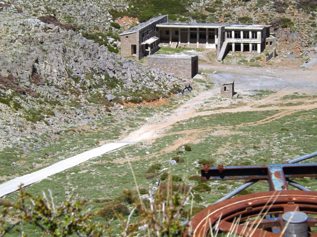
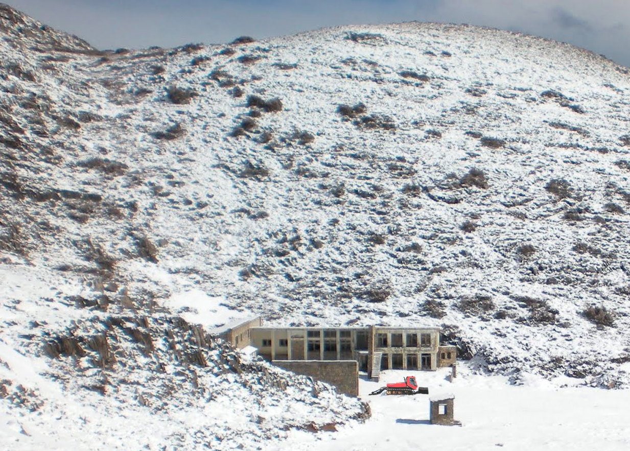
The abandoned ski resort: After three and a half kilometers follows a junction to an abandoned ski resort in a hairpin curve. The only one ski resort of Crete on 1.590m is really worth seeing. So if the conditions of the dirt road are fairly good, give it a try.
After two kilometers, a small ridge and a left hand curve, the impressive building of the ski center comes into sight. Have a look into the garage next to the main building and marvel at the old 160 hp Prinoth T3-200 snow cat. Isn’t that the ignition key to the right of the dashboard?

Anyway, the today’s workout must go on. So follow again the main road to the south and to the restaurant underneath the famous Ideon Cave. After a double Greek coffee, I felt the great desire to climb the Skinakas Mountain again. Go for it!

6.0 Kalamaki- Mournia- Vianos- Mirtos | 126 km | 2.564 Vertical meter | Hors Categorie - 105 km | 1.687 Vertical meter | Catégorie 1
126 km | 2.564 vertical meters | Hors Categorie

“… my mind paralysed by the dreadful shape which had sprung out upon us from the shadow of the fog. A hound it was, an enormous coal-black hound, but not such a hound normal eyes have seen. Fire burst from its open mouth, its eyes glowed with a smouldering glare, its muzzle and hackles and dewlap were outlined in flickering flame. Never in the delirious dreams of a disordered brain, could anything more savage, more appalling, more hellish, be conceived than that dark form and savage face which broke upon us out of the wall of fog”. [Hound of the Baskervilles, Sir Arthur Conan Doyle, 1901]

Out Of The Fog: As I approached the little mountain village, taking curve by curve on the steep slope, the wind suddenly carried a muffled growl towards me. From the silence of the fog, an intimidating howl increased, and then broke off abruptly, only to begin again. Just like the horn of a large steamer that makes a warning sound from amidst the impenetrable grey of the fog above the river without there being any other indication of its presence. No shimmering light, no piece of railing, no mast or superstructure is visible through the veils of fog, not even the stomping sound of the engine can be heard until the bow suddenly cuts through the darkness, towering high above the foaming spray in which it lifts up and crushes the small boat of the fisherman.
So I listened into the silence, foreboding what might await me.
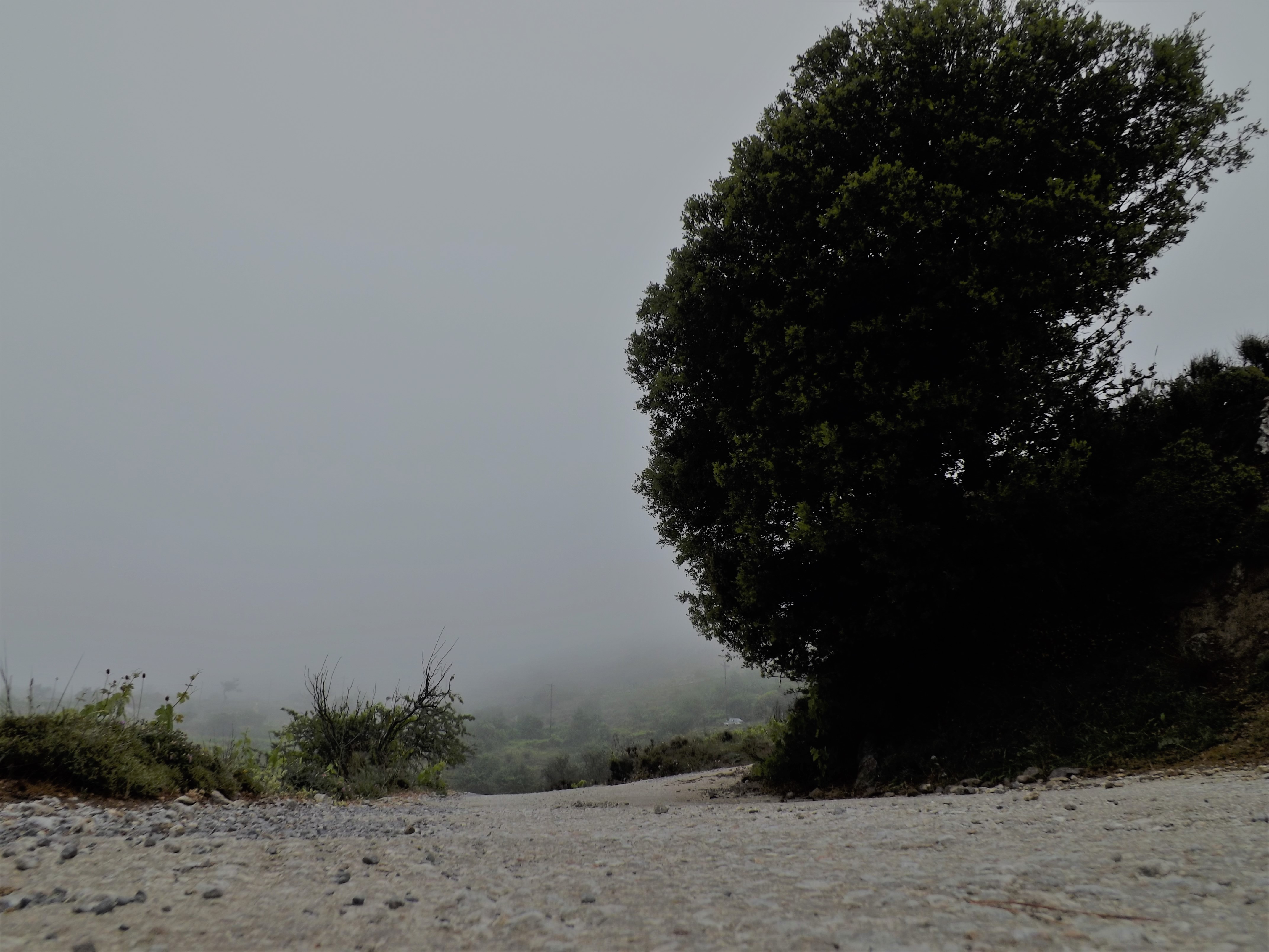
But no sound penetrated the fog anymore, nothing could be heard, no bird sang and my mind fell silent, too. Something was waiting for me up there in the village, and it had noticed me long before I even approached its outskirts. Probably a dog, a large dog, I thought. But I certainly didn’t want to cut across country in this fog, so I had to ride through the village.
Shifting back to a small gear for good acceleration was the first step I took, and then, tense and aware of the danger ahead of me, I proceeded into the village which appeared to be empty and lifeless. There was nobody to be seen on the road, just the fog crawling towards me across the nearby fields and through the gardens.
As I passed the last few houses on level ground, already seeing and heading for the hairpin bend leading downhill at the end of the village, there was a sudden roar and rage from a shack, and, in a cloud of dirt and dust, a large mat of reinforcing steel, probably the steel grating to a kennel, crashed before me onto the road, over which I rattled screaming in horror. Behind me, a heavy, coal-black body fell onto the road, that left a torn rope behind. Already standing in the pedals, I accelerated with all my force and scrambled on towards the end of the village, riding for my life at a crazy pace.
Although surprised by its sudden liberation, the black monster was on its feet in seconds. Spotting the prey right in front of it, it was sure of its success. No longer driven by rage and frenzy, as it had been just a moment ago, the dog put on a joyful smile, and seemed to be delighted by the thought that it would only take a quick run-up to jump at this swirling body, dig his fangs into its flesh, and bring it to the ground…
My pursuer’s moment of wonder and joyful certainty gave me a small lead. Looking back to watch him take up speed, I raced into the bend on the outskirts of the village at maximum speed, dangerously tilted towards the road. I was carried far out onto the opposite lane by the centrifugal force, and so was my chaser, but the force was too strong for his heavy body. His front legs snapped backwards, and he fell on his chest. In a sloping position, his hind legs still upright, the monster was catapulted from the curve, dragged across the asphalt on his chin and chest, and disappeared into the adjacent, accompanied by an indescribable howling.

This happened a long time ago and the all dogs I encountered on this tour will surely be in well-deserved retirement by now. It is not hard to guess that this tour is also about the dogs on Crete. This is somewhat like a hot potato, because on the one hand there are unfortunate creatures like the so-called barrel dogs – watchdogs which are kept on a chain in a tin barrel or small wooden hut by the roadside, in merciless heat and miserable cold, often without sufficient food and water – but on the other hand these dogs can be very aggressive when hikers and bikers pass them. Their task is to keep the goats and sheep of the stockbreeders and dairy farmers inside their pasture area, or, in other words, to keep them away from the path to freedom. (The goats and sheep would otherwise run off to Heraklion, take the ferry to Piraeus and bring the already stressful local traffic to a standstill). According to the current EC legislation, however, this form of dog keeping is prohibited. Nevertheless, these dogs are still used as working dogs by stockbreeders (even if in decreasing numbers).
Many tourists who rediscover their love for cats and dogs on Crete do not understand this. But since they are not worried about factory farming, calf fattening, the killing of millions of chicks, the conditions in their urban slaughterhouses or the perverse consumption of cheap meat in their home countries, their concern is pure hypocrisy. Only credible are the activists who oppose against this form of dog keeping and those who have been seriously threatened or bitten, and rightly point out that extreme caution is required when hikers and bikers pass through such a barrier.
Over time, you’ll develop a sense for where those rusty metal barrels and wooden boxes are located, which are, of course, only to be found in the sheep-breeding and pasture regions, mainly along the sides of the paths and usually below a slightly shady shrub or tree.
If you are dealing with one guard dog on only one side of the path, it is a good idea to dash on at high speed and at the greatest possible distance as long as the dog is still dozing in its barrel. Otherwise, you’ll need to check how far the chain reaches in order to pass by safely.

Do you remember the booby traps in warlike conflicts? It’s treacherous, when a sturdy wire runs across the road at the barrier. This means: Red Alert! On this wire, the chain of the dog is attached and this can now be active over the entire width of the road. A bypass outside the range of action of this dog is recommended.
Two guard dogs: If you are put through the mill by two dogs, one on each side of the road, the situation is worse. This maneuver requires some nerves, because the chains will be just so long that the dogs cannot reach one another. Their maximum radiuses of action are only separated by some 20 inches in the middle of the road. But where exactly is this eye of the hurricane?
Hikers should avoid this passage and take a detour outside the dogs‘ radius of action.
Free-range, aggressive dogs: If you are on your way to the valley after an exhausting crossing of the mountain pass, the willingness to turn around because of two dogs who don’t want to let you pass is very low. I’m sorry to say that, but several targeted stone throws are usually the only thing that will help in this situation. More ammunition and your air pump should be ready to hand, as well. The dogs will belong to someone they accept as their authority, and the handling of working and herding dogs on Crete is not squeamish. Always remember: „Never mind the dog but beware of the owner“.


Little nuisances: In towns and villages, you will often encounter nervous little dogs that specialize in spreading terror. Resting in the shade under trash cans or cars, they stay invisible until they suddenly jump out as the cyclist passes by. They will run after you and bark their head off, but these dogs are harmless, as long as they don’t get suicidal and jump out right in front of your wheels. Stopping and driving on slowly will usually help.
The sleeping monster on the street: It may happen that you casually ride into a small and quaint mountain village, where all the houses and gardens appear to be slumbering in perfect peace. But one bend further along the road, you see a huge dog sleeping in the middle of the road. Well, my experience is that these dogs are older, morally mature, and have developed a more relaxed attitude to life – you can tell by their chosen resting position on the road.
Keeping your distance and choosing a low gear for good acceleration, as well as carefully observing every movement of the dog are nevertheless recommended. I always drive by as slowly and quietly as possible, and the dogs appreciate it. You can usually see one of their ears moving back and forth to scan the noises like a radar dome, and when you pass them, they just open one tired eye and give you a look that reveals their age and wisdom. I only watch them from the corners of my eyes and never look the dogs directly in the eyes.
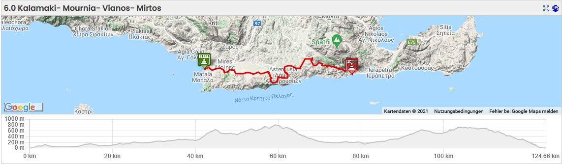
6.0 Kalamaki- Mournia- Vianos- Mirtos - The Tour - Through The Messara Into The Wilderness And To Mirtos | 126 km | 2.564 Vertical meter | Hors Categorie
The Tour – Through The Messara Into The Wilderness And To Mirtos
From Kalamaki through the Messara plain to Mirtos: Starting in the fertile agriculture region of central Crete, this tour from Kalamaki to Mirtos takes you along the Asterousia Mountains and through the Messara Plain to the south coast in the east.
From Kalamaki, follow the road going uphill to the village of Kamilaria, then climb through the steep alleys and up to the ridge. With the snow-capped peaks of Mount Psiloritis glowing in the background, two wide hairpin bends take you out of the shade and downhill to the Messara Plain in the sunlight.
Going uphill and downhill on a steady ascent, you will benefit from the strong northwesterly Meltemi tailwind while you proceed to Plora via Petrokefali, Pombia, Peri, and Platanos, and then head east along the northern edge of the Asterousia Mountains.


The green hell of the Messara plain: While I pass through this green garden from stem to stern, I slowly become tired of the scenery. The endless succession of olive groves, cereal fields, small villages and gardens may feature some extraordinary sights such as a tractor sitting in the shade below bougainvillea or an old English anti-aircraft gun by the roadside, but I long for a change of surroundings, and wish to return to the great and spectacular theatre of the mountains, the cyclist’s arena of passion and pain.
But if you don’t miss the mountains, go straight ahead here and proceed from this point along the northern flank of the Asterousia mountains to Mesochori. By this shortcut you save 20 km and 1,000 meters in altitude [Overall distance 105 km and 1.687 hm – Catégorie 1].
Passion and pain:


At the village of Charakas, where everything glows in the midday heat, a small, unremarkable road leads you past orange trees and into the mountains. Above it lie the ruins of a monastery, a little church, and a cross, and you can hear the faint sound of a bell ringing in the wind. Leaving you breathless, this path goes constantly uphill in wide curves, and takes you through the soft landscape forms of the marls and limestones of the Pindosflysch and past the towering cliffs of the Pindos limestones.
Up into the mountains: With every turn of your filigree wheel, your heart pushes you forward. All alone in this ascent, accompanied only by the shadows cast by the clouds, I proceed uphill to the pass at 650 meters. For several minutes, I am struggling on amidst a galloping herd of sheep, and deep down below, the Messara Plain is flickering in the midday heat like a mirage. Sheep breeding, as well as olive, cereal and vineyard cultivation dominate the plains. Far to the horizon extends the dark blue of the sea.

After a six-and-a-half kilometer ascent, I reach the left turn just ahead of the village of Paranimfi that takes me in the direction of Tri Ekklisies. The narrow, meandering road is lined with small houses, but soon enough, it transitions into a wide asphalt road. Completed in 2015, the road leads through the fantastic mountain scenery of limestone crests, marl and slate for about eight kilometers – all the way up to the beach village of Tri Eklisies on the south coast.


But after some two kilometers turn left again towards the east and half a kilometer further on, turn right on the three-kilometer dirt road to Mournia.
Mournia: On the eroded, steeply ascending passages, it is advisable to push your bike until you reach the asphalted road just ahead of Mournia. Its church standing a bit further away in the small valley, this typical Cretan mountain village is made up of narrow-faced, flat-roofed one-room houses. The stove, cooker and laundry utensils are located outside at the side of the house. Through the open doors you can see the sofa bed, a bench decorated with fabric, a few jugs, a plate shelf, photos of the ancestors, pictures of saints, and a cross. More possessions are not needed.
Passing a row of old, abandoned houses, the route proceeds across a hilltop and into a small valley. The next stage is a steep, five-kilometer climb with gradients of up to 14%.
It takes you all the way through the gently winding valley of Ethia, and up to the pass at 800 meters. Towering high above you are the Pindos limestones of Mount Asfendilias [979m] with the OTE antenna station. A two-kilometer asphalt road with an average gradient of 10% (max. 16%) leads up there.

Before Achentrias, there was a beautiful chained dog lying in his tin shack at the roadside. This intelligent animal would have been a faithful companion for every human being, but he carves out a miserable existence as a convict. Chained up, his thick fur exposed to the scorching sun, he spends every day waiting for a few scattered sheep to attend to or for someone who has mercy with him, and gives him some water and affection.
In wide curves, the road now leads downhill for some 15 kilometers and 600 meters in altitude, passing the villages of Achentrias and Mesochori.

From the depths of the ocean: Just like an exhausted swimmer who reaches the shore after a long workout and the hand is already laying on the wood of the boardwalk to leave the water, so I reached the village of Mesochorio. And just like the unsuspecting swimmer, who puts his hand on the railing, to step out of the water, I rode through the narrow streets of the village, not knowing that from the darkness into the blue, from the depths of the ocean, a large predator was dashing up to the surface. The streamlined body, only dimly recognizable in the first rays of light that penetrate into the depths, reaches the swimmer, hits him in the back with a brutal thrust, and drags him under water.
And as unexpectedly as the big predator from the depth came to the surface, suddenly a huge animal stood in the middle of the road, right in front of me.
Had I been travelling by car, I would immediately have locked the doors and windows, and would still have been nervous to pass by this gigantic Great Dane. Turning back was impossible, and turning my back to the giant was no option, either. So I stood there, bent over my bike, and carefully took off my helmet and sunglasses. Observing each movement of the dog, I tried to sneak past him at walking pace. Appropriately enough, the cemetery was located to the right.
Almost at eye level, we were now facing each other, and stood so close that I didn’t dare to breathe or move. He had a narrow face with a huge dark nose, elephant-like ears, and a wrinkled forehead. He gave me a gentle nudge from the side, and his thoughtful facial expression seemed to ask: “What’s your problem, you funny man?” Then, without further ado, he disappeared into the alleyway.

The gray band of the road slid under my wheels into the past, I crossed the river Anapodiares, climbed 1,000 meters uphill to Ano Vianos in scorching heat, and further on to the pass.
The clouds drifted across the sky like giant ships, it was windy, then stormy, and then the rain came pouring down.
The raindrops hurt my eyes, but I didn’t even think about putting on a rain jacket. My helmet was hanging from the handlebar since I left Mesochorio and the sunglasses were still in it.
I was in a trance, in a mystical fable world full of talking animals, caught in a dream spinning around in my head, from which I only woke when I arrived at the restaurant on the waterfront promenade in Mirtos, where I ordered a double Greek coffee and two glasses of raki, which I emptied immediately. The friendly owner did not bat an eyelid – he must have been familiar with the circumstances in Mesochorio.
6.1 Kalamaki- Kamares- Amari Plain- Gerakari- Spili - The Haunted Palace | 76 km | 2.138 Vertical meter | Catégorie 1
76 km | 2.138 vertical meters | Catégorie 1

The Haunted Palace
In the greenest of our valleys
By good angels tenanted,
Once a fair and stately palace
– Radiant palace – reared its head.
In the monarch Thougt’s dominion,
It stood there!
Never serap spread a pinion
Over fabric half so fair!
Banners yellow, glorious, golden,
On the roof did float and flow
(This – all this – was in the oldenTime long ago),
And every gentle air that dailled,
In that sweet day,
Along the ramparts plumed and pallid,
A wingéd odor went away.
(Edgar Allen Poe; April 1839)
The Haunted Place: Let’s assume you are in a strange place and wake up at night from a noise – the scratching of a branch on the house wall, the call of an owl, or the rustling of the leaves in front of the window through which the moon shines brightly into your room. A peaceful night, were it not for the projection of three large crosses on the wall of the room – grave crosses, that is, each of them topped with a wreath. And amidst these black shadows stands something that dulls and liquefies the moonlight, something like a veil flowing through the window and into the room, clearly raising its hand to greet you.

The good news is: You are not travelling through Romania, so Vlad Tepes, also known as Vlad the Impaler or Vlad Dracula, cannot be the visitor. No, it is much more likely that a rather harmless ghost from the neighboring cemetery missed the entrance of the inn where you found shelter, and is now heading through your room for the bar – perhaps. One thing is for sure, you are in a haunted house.
Humanlike ghost phenomena have a considerable range of terrifying items at their command. These indispensable ghost props include a large cape which always hides the skeletonized face, and a skull that the spirits tend to carry in their hand. If they carry a scythe instead of a skull, caution is required, because these kinds of spirits have obviously lost something they are trying to regain. Everybody knows that ghosts just love to tug and tear at chains with a clanking sound, but they also play the flute or bagpipe which can be very annoying, as well. And if you remember Mrs. Rochester in Charlotte Brontë’s novel Jane Eyre, you will be aware that spirits in any kind of wedding attire should raise serious concern.
Travelers will now ask themselves if there are any enchanted places on Crete. Clearly yes, and they are countless. Whether you wish to explore them or not is completely up to you. But if you perceive a moldy smell, see distorted faces, or hear someone moaning and groaning, your strange encounter will not necessarily involve ghosts but much more likely members of a bicycle tour – which brings us to the subject.
The Tour from the southcoast at Kalamaki via Kamares, the Amari Valley and Gerakari to Spili: The lush green meadows of the Amari Valley are the defining element of this tour which leads from the south coast near Kalamaki via the northern slope of Mt Kedros and its pass to Spili in the northwest.

There are many possibilities for exploring the Amari- Basin, for a round trip, climbing the ridges high above the valley. Or you open the door to the secret garden of the river plain, the magnificent natural beauty with enchanted places like the monastery of Asomatos, Byzantine churches and basilicas, springs and fruit-laden orchards, wealth of diligence with the village Amari in the center. The ancient palaces near Monastiraki and Apodoulou bear witness to the importance of the region in Minoan times. Taking you back towards the east for some 50 kilometers, the well-developed road south of Mt. Kedros runs past Akoumia, Agia Gallini and Timbaki to the Messara Plain and to the south coast near Kalamaki.
The village of Apodoulou – The Frankish Konáki

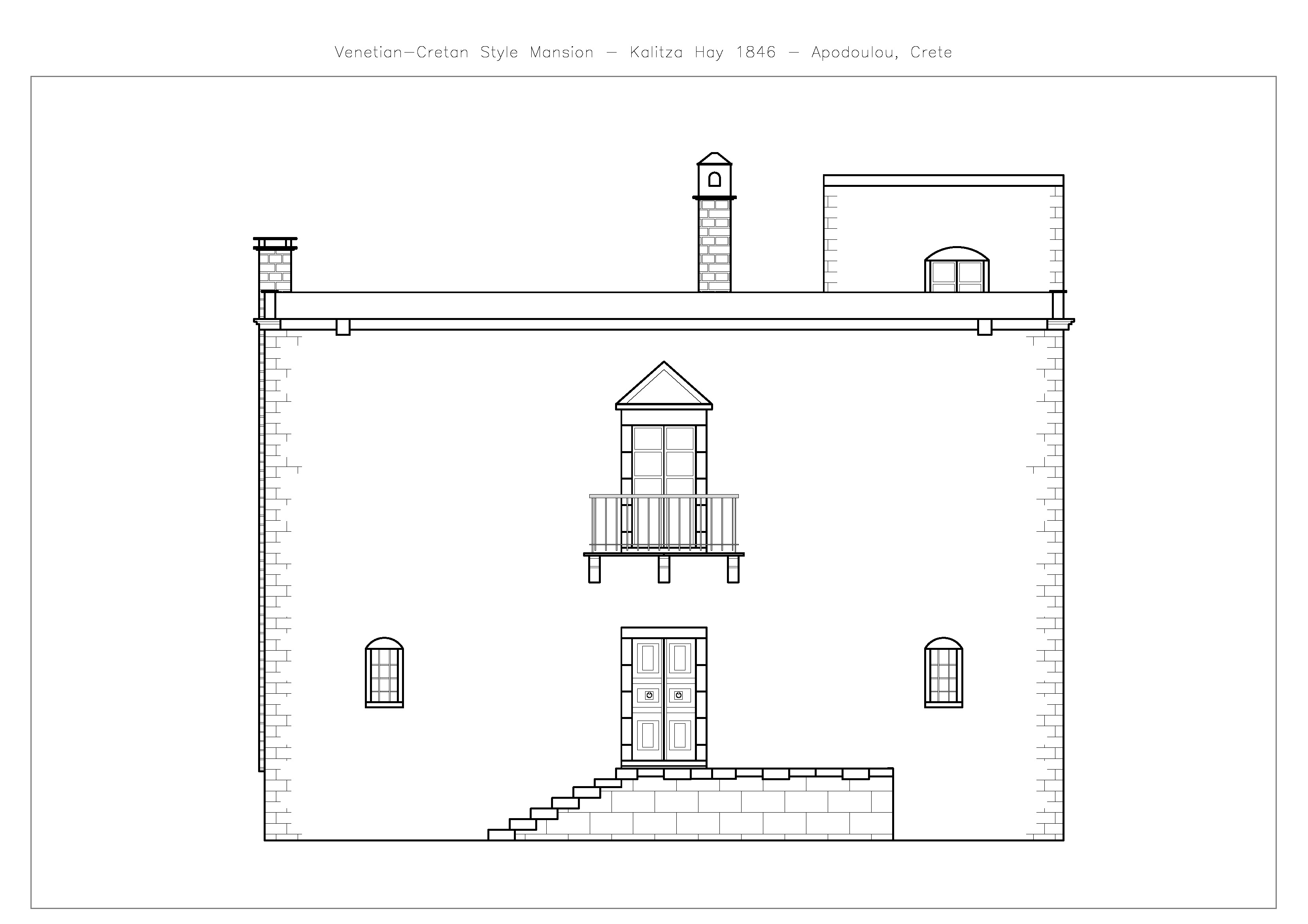
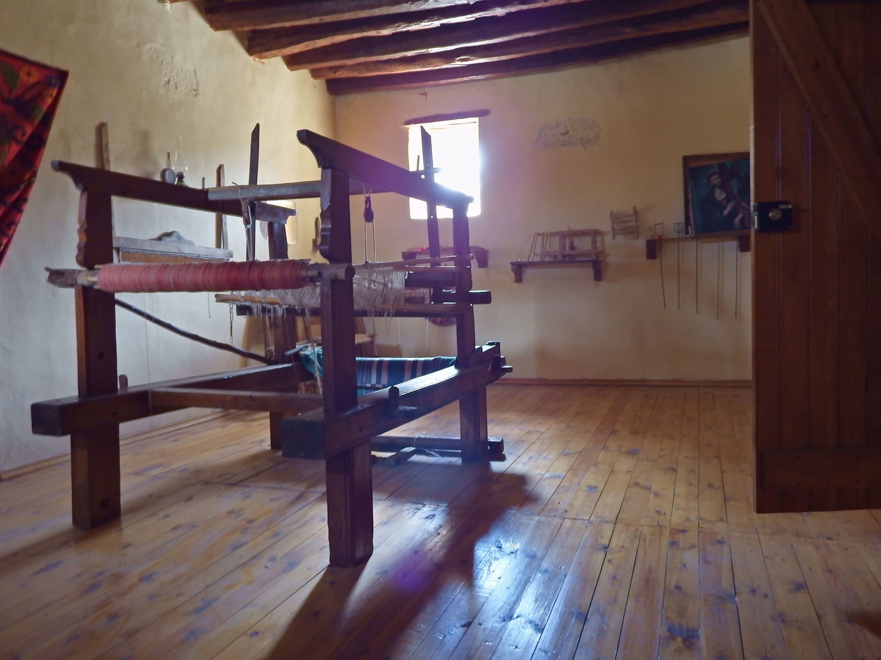
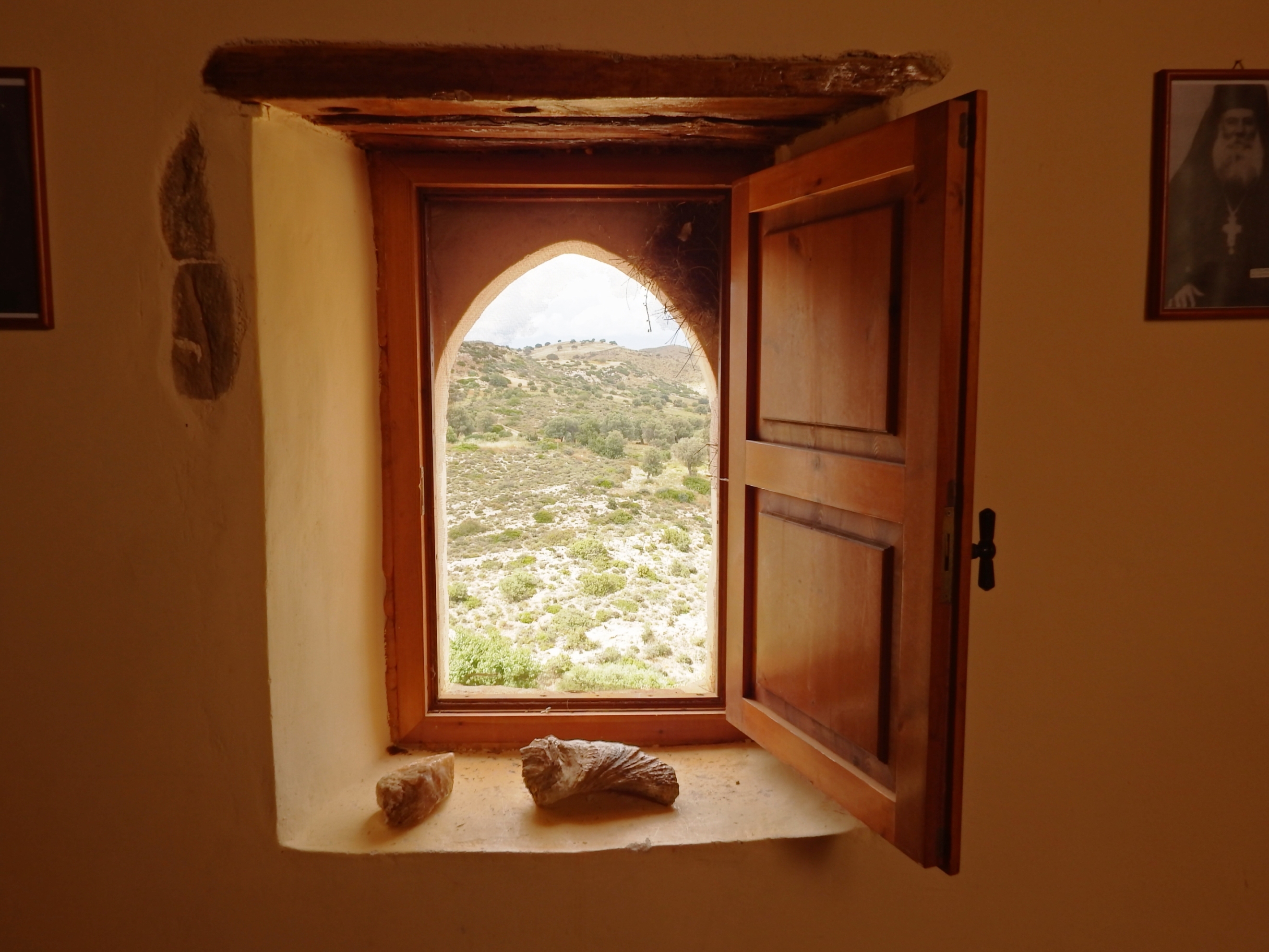
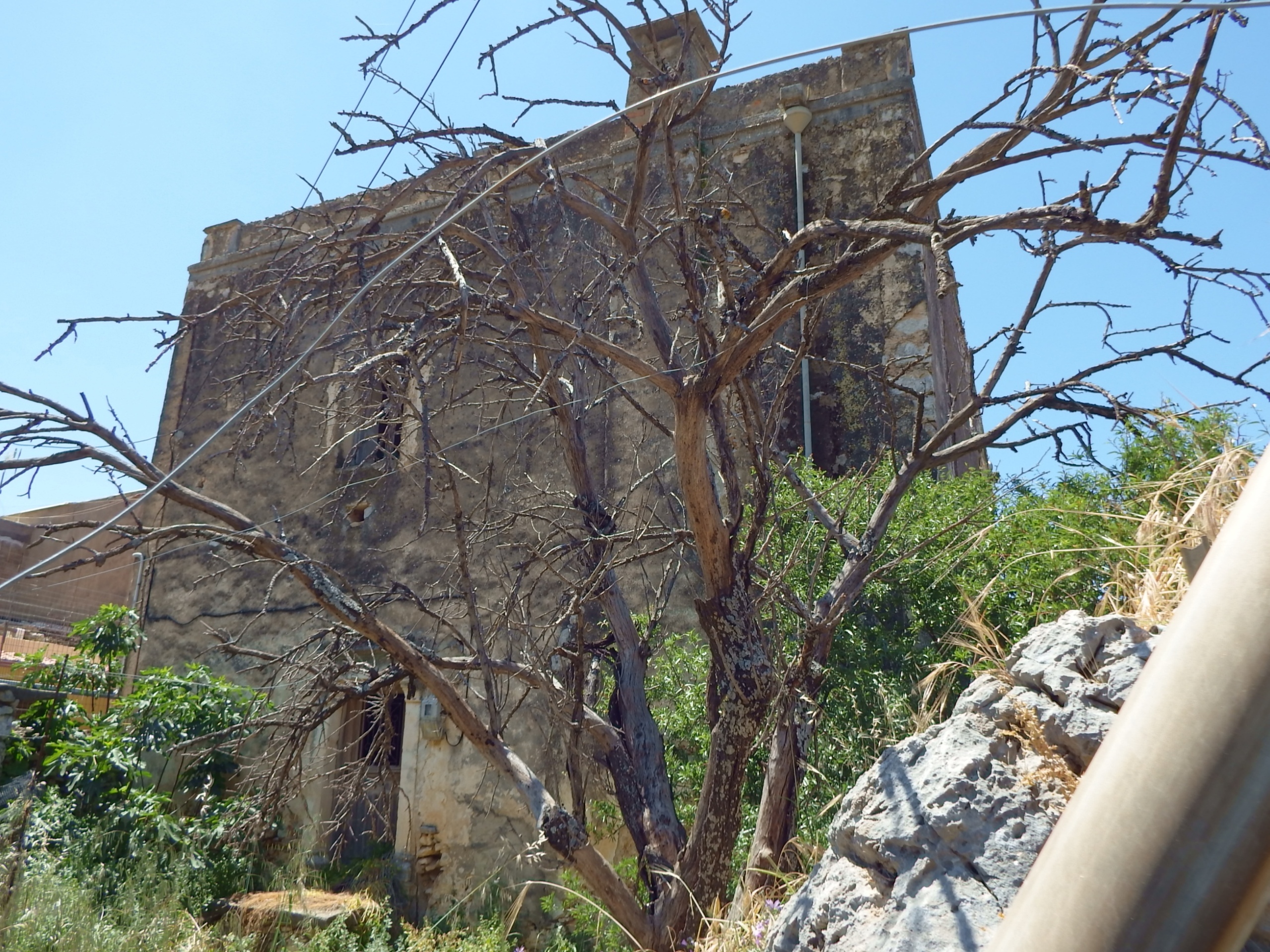
While I rested at the fountain of Apodoulou, on the opposite streetside, a formerly magnificent and large house towers up. With its broad street front and the now dark and hollow window caves, it rises proudly and venerable from the surrounding walls. A villa bearing style elements of a simple Venetian country house, built of quarrystone masonry and solid mortar. The walls are mainly plastered, but at the corners of the building you can see the characteristic exposed brickwork of coarsely hewn limestone.
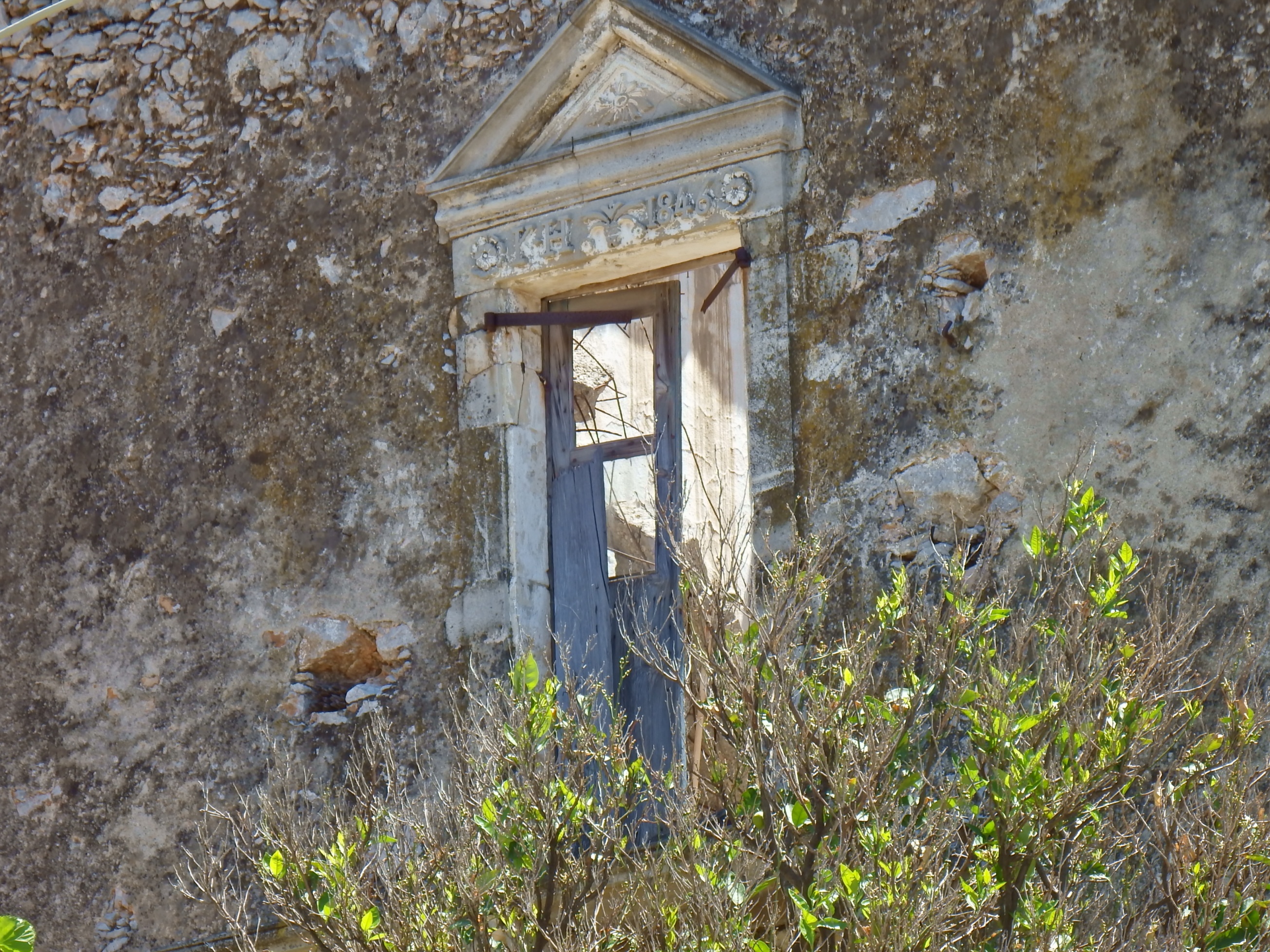
The windows and the pórtella facing the street boast carefully carved limestone edgings. The crossbeam of the door is adorned with rosettes and two stylized fruits of the kermes oak. Above it, on the first floor, a high Renaissance-style window is decorated with stylized flower ornaments, the initials „K.H. 1846“, and a tympanum. There is a small balcony in front of it. The patio roof is girded by the stone ribbon of the Kordòni.
The mighty limestone steps of the staircase lead up to the entrance door and into the hall, the pórtego.
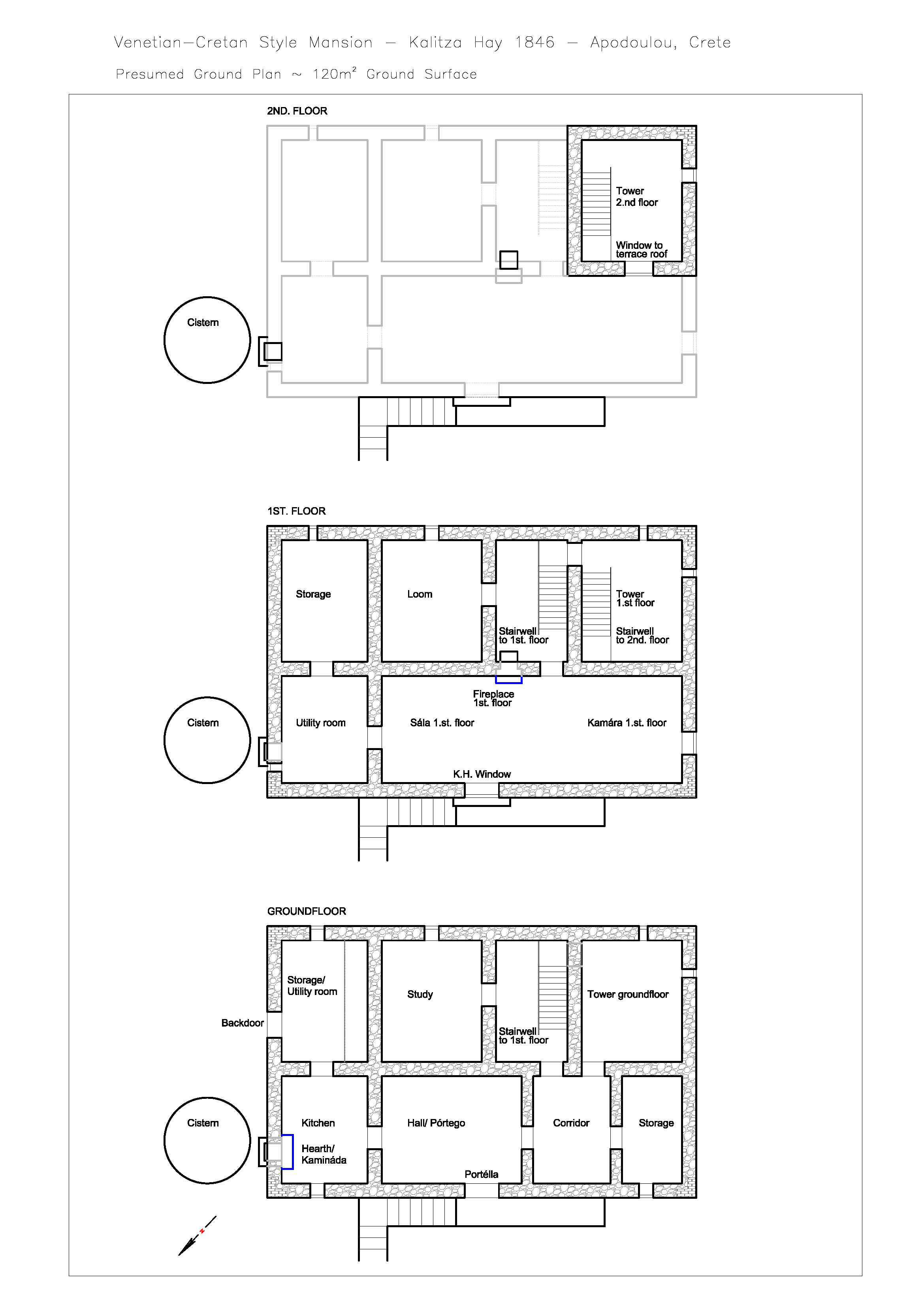
The original entrance to the kitchen with the large fireplace used to be on the left side. Facing the street, there are two more rooms to the right. The room directly adjacent to the hall forms a corridor leading into the rear part of the house, where you have access to the now collapsed wooden staircase. On each floor, there are rooms to the left at the rear of the house. Their southeast-facing window openings are specially adorned with round arches.
The stairwell extends over the 1st. floor of the Anòi to the tower-like rooms of the 1st. and 2nd. floor, here with one window facing southeast and one facing the patio roof. In the rear part of the building’s narrow side, two further rooms can be found on the 1st. floor. Parts of the wooden ceilings to the 1st. floor are still preserved.
On the ground floor of the northeastern narrow side of the house you’ll find the rear entrance that leads from the courtyard to the kitchen wing, which is separated from the house. The cistern is located in the courtyard to the right of the entrance. The rear entrance takes you to a small hall with brick cupboards, and the kitchen is located to the right.
The house has obviously been divided into two parts in modern times, and this area now features a concrete staircase leading to the 1st. floor. Its stairwell cuts brutally through the window opening, the original wooden ceiling, and even the supporting wooden beams. Around the same time, a new window opening was built into the northeastern outer wall of the 1st. floor, reinforced concrete stilts and girders were inserted at the rear, and the partially collapsed patio roof was replaced by a reinforced concrete ceiling. In the area that is the sála, the concrete ceiling has collapsed again.
Travelling back in time – As I walked up the big, hewn limestone blocks of the stairs and entered the villa through the double-winged entrance door, I daydreamed hundreds of years back in time.

I imagined the large family sitting at the long table, drinking with their friends. Stories came alive, children played, and I heard voices, music, noise and laughter. The Laouto sounded, and the deep red Liatiko – Mandilari sparkled in the glasses. Then a chair was pushed back vigorously. The air condensed to a liquid and out of this, a denser zone in human form cristallized, which approached me in fast, fluent movements. There was a cold touch on my cheek and a something whispered into my ear. – And everything swirled around me, raging and roaring like waves crashing against rocks, growing louder and louder, voices, music, noise and shouting, saw ghosts from a bygone era dancing around me until I was dizzy and staggered backwards into the garden.
Now, if this house is not an enchanted place where spirits meet, it certainly has an adventurous and tragic, yet unique and beautiful story to tell.
Kalitza Psaraki [*1802 – † 1885]
During the Greek War of Independence [1821-1829], Turkish soldiers of Ibrahim Pasha’s troops moved from Timbaki to the Amari Valley of Crete in 1823, plundering and burning the villages. The inhabitants of Apodoulou fled to the mountainous region in horror, but four of the old people who remained in the village were instantly beheaded by the troops. Off the road, Turkish soldiers discovered and captured several children and their mother from Apodoulou. Among them were Kalitza Psaraki, the daughter of the chief magistrate of Crete, and her siblings. In order to be sold at the slave market in Cairo, they were brought to Chania and embarked to Alexandria.
But Greek freedom fighters attacked the ship and took the kidnapped people to the isle of Kasos where the Greek rebels’ fleet was located. Shortly afterwards, in 1824, the Turks conquered Kasos and enslaved nine hundred local women and children, including Kalitza.
Robert Hay [*1799- † 1863] of Linplum
was 25 years old when he first travelled to Egypt for study purposes. Shortly before that, he had inherited his family’s estate in Scotland. So he was a man with some fortune, able to employ artists who, like himself, had outstanding skills in documenting and drawing Egyptian antiquities, temples and tombs. Among his friends and companions were pioneering Egyptologists and orientalists such as Gardener Wilkinson, Edward William Lane (nephew of the painter Thomas Gainsborough), as well as artists such as Joseph Bonomi and Frederick Catherwood.
In December 1824, Hay set off from Cairo on a journey up the Nile in order to visit and document the historic sites of Abu Simbel, Kalabsha (Beit al Wali), Philae, and Thebes. He produced comprehensive architectural plans as well as detailed copies of the murals and inscriptions. His panoramas are particularly impressive.
When he returned to Cairo in February 1825, he took up quarters with Edward Lane, who had come to Egypt in 1825. Lane had rented a house in Cairo where he worked as a Turkish Bey, drawing and writing. In Hays company were two young women, dressed as Turkish men. One of them wore a huge turban, mischievously smiling – Kalitza Psaraki. In 1824, Robert Hay had bought her and some other Greek girls’ freedom at the slave market in Cairo and supported them from then on.
From November 1824 to 1828 and from 1829 to 1834, both of them travelled Egypt. They went along the Nile, up to the 3rd. cataract and to Nubia, where Hay and his companions created a fantastic image of the historical sites, Egyptian everyday life and written testimonies. Their work comprises portraits of many sites in Egypt which are now destroyed and are only preserved thanks to their records. Today, you can view these testimonies of the past at the British Museum.
Kalitza and Robert got married in 1828 while passing through Malta on their way to Scotland. Together with several artists and architects they had employed, they travelled Egypt again from the end of 1829 to May 1833, this time recording the extraordinary grave decorations of the rock tombs of Beni Hasan in the Middle Kingdom in detailed colored copies. They continued their work in Amarna, Asyut, and Nubia. In 1834, shortly after the birth of their daughter Henrietta Maria Hay, they travelled Crete to visit Kalitza’s family. Later on, in 1835, they returned to Scotland, where indispensable tasks regarding the family property awaited them. The couple had three more children, Kalitza Janet Erskine Christian Hay, Robert James Alexander Hay and James William Hay.
Due to purchasing Nunraw House, Robert Hay had meanwhile become Esquire of Linplum and Nunraw, and was so occupied with the management of his estate that further journeys to Egypt were no longer possible, to his great regret. In 1840 he published his unfortunately only book of a planned series of publications [Robert Hay, Illustrations of Cairo, published in 1840].
Built in 1846 in the style of a Venetian country house, the holiday home in Apodoulou bears evidence of this beautiful Cretan-Scottish love story.
The sympathic and friendly relatives of Karlitza Psaraki, Aristides and his wife, are still inhabiting the property. So they worked in the 60’s in northern Germany near Lüneburg, they speak very good german.

6.1 Kalamaki- Kamares- Amari Plain- Gerakari- Spili - The Tour - The Way To Amary Valley | 76 km | 2.138 Vertical meter | Catégorie 1
The Tour – The Way To Amari Valley
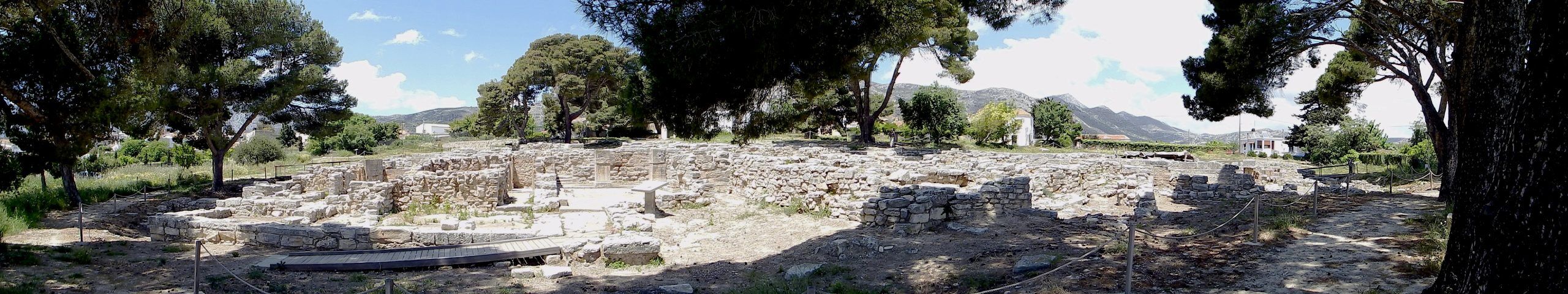
From our starting point in Kalamaki, or from wherever you come, the first stage of about 16 kilometers and 550 meters in altitude takes you via Kamilari – past the minoan palace complex of Festos, and crossing the Messara plain in a northerly direction – and then via Vori up to the village of Kamares.
At Kamares, you will reach the picturesque mountain road featuring a connection to the Amari Valley. On the southern slope of the Psiloritis mountain range, it winds itself uphill and downhill through the villages of Platanos, and Apodoulou, and to the junction of this tour at Nithravi, before it proceeds further to Thronos in the northwest. Providing views of Mt. Kedros [1,777m] and across the valleys, more and more breathtaking panoramas are to be enjoyed. Their houses tucked away under rocky ledges, the villages are nestled on the steep cliffs of Mt. Psiloritis [Timios Stavros 2,456m], and high above all this the mountain of Zeus with its snow-covered peaks sits enthroned.
Two more roads to explore the Amari Valley

South of the Amari Valley, coming from Nithravi, you’ll ride downhill into the valley of the river Platis via Agios Ioannis, before you proceed to climb the steep serpentines on the northern slope of Mt. Kedros, hairpin bend by hairpin bend, all the way through the villages of Chordaki, Ano Meros, Drigies, Vrisses, and Kardaki, until you reach the village of Gerakari at 600 meters of altitude and cross the pass of Mt. Kedros towards Spili at 850 meters of altitude.

In the valley bottom, the road runs through the rift zone between the Pindos limestones of Mt. Kedros and Mt. Samitos as well as the Tripolitzakalk of the Psiloritis mountain range. Via Amari and Monastiraki, it takes you from Meronas to Fourfouras or Agios Ioannis (partly unpaved).
Here, the sycamore trees are already in bloom in April. Along the course of the stream, they are soon to be joined by the bell-like, pale pink blossoms of the oleander, as well as water lobelia, hyssop, monk’s pepper, and the occasional light pink blossoms of the Judas tree.
Covered with maidenhair fern, the shady, damp rock walls show themselves off in their most splendid garb. With purple loosestrifes lining its banks, the brook gurgles merrily, and a pleasant coolness surrounds you.
This lavishly equipped fairytale world is filled with the bubbling sounds of the rivers, and the wind sweeps across the reeds of Geropotapos, Amarinos, and Platis with a soft hum, almost like a flute melody, for all the shepherds and nymphs to enjoy.
The roads leading down into the valley are lined with broom glowing in yellow and filigree flowering myrtles, while red and blue anemones make for a splash of color in the fields. The surrounding mountains protect and feed this water-rich, fertile valley. Thanks to the cultivation of grain, fruit and olives, it is famous for its cherries, morellos and apricots, as well as delicious apples and peaches.

The hospitable inhabitants of the small villages of the Amari Valley are known for their calm, balanced, and friendly nature. In Crete, they are regarded as exemplary for their diligence and their uncomplicated, straightforward manner.
6.2 Kalamaki- Kali Limenes- Kalamaki | 50 km | 1.696 vertical meters | Category 3
50 km | 1.696 vertical meters | Category 3

Someday we’ll look back on this moment and plough into a parked car. [Evan Davis]
Carom is the most demanding variant of billiards. Using the cue ball, the player transfers the entire force to the other two balls, whereby – in case of frontal impact and equal mass – both are pushed into new directions at an angle of 90 degrees. Contrary to the physical laws of elastic impact, small events in human life can often have more serious consequences. They’re the kind of consequences that, while you’re enjoying your morning coffee in peace without suspecting a thing, you would never expect to become reality so soon.
An Occurrence At Old Grasshopper Bridge: It was a fantastic tour, and life seemed so easy this sunny morning. I went downhill at high speed, left two bends behind me, shifted gears, and started to sprint over the small plateau in the direction of Kali Limenes at full power. Suddenly I was hurled off my bike and fell hard onto the road. On my hip and elbow I slid across the asphalt, which rasped my skin from my leg and forearm. I was flung across the road diagonally and ended up in the ditch by the opposite rock wall, followed by my rattling bike.

Lying halfway on my side in a posture as if I was still holding the handlebars in my hands, I couldn’t believe that this had really happened. The dirt of the road had dug deep into the abrasions on my arm and leg, which would clearly require some brushing on in the evening. For the elbow that looked like a mushy tomato at the end of the tour, the only remedy was surgery.
Martin Brasier so sensitively tells us in his story about the “Albert And Emily Effect”, how much Emily, “a dainty little thing, who liked to read poetry while sitting on a chaise longue and sipping a glass of cream sherry” hated it that her husband Albert had formed a habit of smoking big, fat Havana cigars in bed. Albert was banished to the balcony for smoking. But one day, Emily couldn’t take that, either. She gave Albert a slight push, and he fell down from the balcony into the flower bed.
Fortunately, they lived on the first floor, so that Albert, who was a little confused, could pull himself together again. A few weeks later, the opportunity arose to move to the tenth floor, “to enjoy the beautiful view from the balcony” as Emily so charmingly put it. The one fateful evening, Emily repeated the same operation – the same gentle push from the same kind of balcony. Over the edge tumbled poor Albert, wearing the same kind of string vest and the very same kind of braces. And thud went the flower bed, putting out the same kind of cigar. But out went Albert, too, stubbed out for ever.” [Martin Brasier – Secret Chambers – the inside story of cells and complex life, Oxford University Press 2012].
It was not the small push in itself that took Albert’s life, but the kinetic energy stored by him that led to this fatal outcome, which he had survived so well on his plunge from the first floor.

And so I felt like Albert, because the trigger to my fall was an Emily as well (at least that’s what I called it later). Just as I turned onto the straight road and accelerated with all my power, Emily jumped up out of nowhere, straight into the rear derailleur, blocked it with her shell which had hardened for almost 300 million years of evolution, and got jammed between the first jockey wheel and the chain.
My Emily was a descendant of the Egyptian locust (Anacridium aegyptium), and had reached a remarkable size of almost 7 centimetres by the day of our fateful meeting. The derailleur hanger was bent, and, together with the derailleur, leaned dangerously towards the spokes of the wheel. In wise foresight I had bought a spare derailleur hanger at www.derailleurhanger.com before I started my tour.

Kalamaki – Kali Limenes: Riding uphill from Kalamaki towards dreamy Kamilari, past the houses adorned with bougainvillea, and from the shade of the plane trees out into the sun, two large bends lead down to the Messara plain. With the gentle breeze of the Meltemi behind you, and accompanied by the buzzing sound of the freehub pawls, you rush through the soft landscapes of the neogenic marl and limestone of the Messara Basin. For more than eight kilometres from west to east, via Petrokefali to the turn-off to Pombia, wheat fields line up and create a golden glow in the bright light of the morning sun. They have been cultivated since time immemorial.


Cereals, vegetables, wine and fruit grow beside and under the olive trees, and every Saturday morning the farmers meet at the large market of Mires.
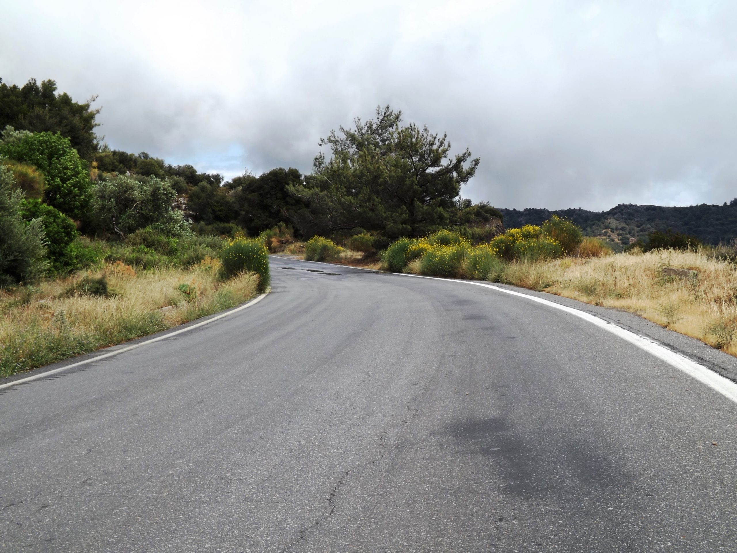
If you turn right towards the south just before you reach Pombia, the hard climb up to Pigaidakia and into the Asteroussia Mountains begins. The seven kilometres to the pass are really tough. In a slight ascent, the road first goes straight ahead towards Pombia, and then winds up to an altitude of 500 metres in steep hairpin bends leading through the flysch of the Pindos nappe, through limestone, sandstone and Miocene marl. One slope follows another without a chance to catch your breath.

Descent to Kali Limenes: Once you have crossed the pass and are descending to Pigaidiaka, the landscape becomes magnificent. In spring, the bushes blossom in yellow and red, flower meadows merge gently into one another and there is a fresh smell of poppy, thyme and sage. One kilometre beyond Pigaidakia, crossing a small stream, you will cycle across the „Grasshopper Bridge“ (which is rather unspectacular compared to what was described above) and enter more rugged landscapes. Metamorphic rocks now dominate the scenery with phyllite slates, marble and gneiss. You proceed through several small valleys and over a hilltop at 380 metres before you can look out far across the Libyan Sea.

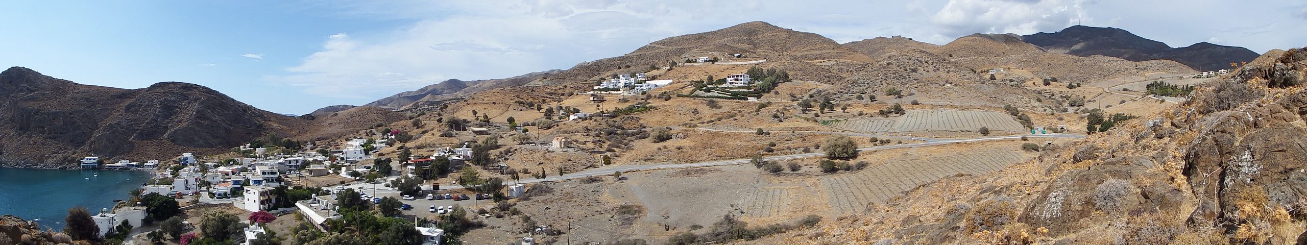
You will reach the coast after five more kilometres of the most beautiful descent. At Makri Ammos beach, there are some tents set up under tamarisks. Turn right and go to the southwest for another two kilometres. Voilà, you are in Kali Limenes, one of the ports of Gortyn in Roman times, and the historic place where the apostle Paul landed, east of Cape Lithinion, on his portentous journey from Caesarea to Rome in 59 A.D. (Acts 27:8).

Kali Limenes: A few olive trees on the slope, some houses, huts under tamarisks, men in boiler suits, a seamen’s hostel, a tavern, a weathered playground. A taxi arrives, a lady “du salon de la rue des Moulins” gets out.
Now the view to the south: A bay with crystal clear water, a fisherman on his boat, a supply port, and four large steel tanks on the offshore island of Mikronisi which houses the fuel station of the Greek oil company SEKA, and supplies the ships travelling through the Mediterranean and the Suez Canal with fuel.


It was almost like being in a contemplative version of the port of Hamburg. I sat on the terrace of the „Old Port“ tavern overlooking the bay, watched the busy ship’s chandlers and supply ships, and drank some cold, red wine, while laughter and shouts were blown across from the nearby „Seamen’s Club“. I was thrilled.
SEKA was founded in the early 1960s by oil entrepreneur Nikos Vardinogiannis in Kali Limenes, and means „Fuels Bunkering Station“ („Stathmos Ephodiasmou Kafsimon“). It is a filling station (with the meaning of „petrol station“) for ships. The station is located just seven nautical miles from the major shipping routes, such as the one to the Suez Canal, and in addition to the bunker service as a ship chandler, it also supplies the ships. The four large and three smaller tanks hold 31,000 tons of bunker oil.

From the coast to the Monastery of Odigitrans: In the direction of the Monastery of Odigitrans, the road above the houses continues to the west. After some 500 metres, it turns right and to the north at the small church. This is where the sand track starts. The church of Agios Pavlos is located on a hill a few metres to the west of the road. It was built on the same spot where an old church dating from 1700 once stood.
On a dusty track, we cycle two kilometres uphill to the first pass at an altitude of 170 metres. From there, the path descends into the river valley, which continues through the Agiafarago gorge to the south.
From the dust of the quaternary marls and limestones rises a small oasis of oleander and tamarisk with an abundance of red and white flowers. The three kilometre path that takes you to the gorge branches off about 800 metres ahead of the stream crossing. On the left side of the valley the path goes uphill again for about three kilometres until you reach the monastery of Odigitrias at an altitude of 230 metres.
Here your wheels touch asphalt again, and you’ll cross a small plateau before the last ten kilometres of the hilly road will take you downhill to the coast to Kalamaki via the villages of Listaros, Sivas and Kamilari, which are all situated on small hills.


6.3 Kalamaki- Kapetaniana- Kalamaki | 77 km | 1.906 vertical meters | Category 2
77 km | 1.906 vertical meters | Category 2

There’s a race of men that don’t fit in,
A race that can’t stay still;
So they break the hearts of kith and kin,
And they roam the world at will.
They range the field and the rove the flood,
And they climb the mountains crest;
Theirs is the curse of the gypsy blood,
And they don’t know how to rest.
[Robert William Service, The Spell of the Yukon, and Other Verses (1911)]

This is serious! This is training. Plains and mountains as well as interval training on hilly and increasingly steep terrain are the determining elements. The first part is a fast ride through the Messara plain, we run in quickly and with ease. After ten kilometres, intensive interval training is on the agenda – on a varied and winding route to Loukia via the villages of Pombia, Alithini, Peri, Platanos, Plora, Flathiakes, and Vasiliki. The route features short, then increasingly longer ascents on a hilly route, and short, fast descents through green, blooming maquis and olive groves. On this 20 kilometre interval section, we cover an elevation gain of approx. 500 vertical metres with an incline of up to 8% and a difference in altitude of 200 metres between start and finish.
Then, for some eight kilometres, a difference in altitude of 650 metres and with an average gradient of 8%, the big ascent into the barren Asteroussia mountains, all the way to the pass at 830 metres above the mountain village of Kapetaniana, follows. On the slopes, we have to manage gradients of up to 17%.

Through the Messara: Our starting point is the beach village of Kalamaki, a little buffeted by the wind, with a handful of small B&Bs and apartment blocks, a few supermarkets, car rental firms and a number of recommended taverns along the seaside promenade. It looks out to miles and miles of sandy beach, excellent for bathing and swimming. Situated to the east is the fantastic but unfrequented sandy beach of Kommos, home to the excavation site of the ancient port of Festos. Further east, you’ll find the village of Matala. Kalamaki is an ideal base for swimmers, runners and cyclists, as well as for tours to the Ida Mountains, to Spili in the west or for climbing with your bike in the Asteroussia Mountains around Kali Limenes, Lendas, and Kapetaniana in the east.

From Kalamaki, the route proceeds uphill for three and a half kilometres, across several small hills, until you reach the picturesque village of Kamilari at 110 metres above sea level via a last short and steep ascent of 15%. Kamilari is a typical agricultural Cretan village. On the way through the winding alleys, past old stone houses adorned with bougainvillea and vine, you’ll find the way to the Kafeunion in the centre of town, where you can enjoy a Greek coffee or a glass of chilled Cretan country wine in a typical Cretan ambience. (In spring), the snow-covered peaks of Mount Ida flash up in the distance.
In Kamilari, turn right and take the two large bends leading down to the main road coming from Matala. Turn left and ride through the Messara plain to Pombia and towards the east. With a length of 40 kilometres and a width of about eight kilometres, the plain is Crete’s largest growing area for crops and vegetables. Shielded from the Libyan Sea by the Asteroussia Mountains in the south, the plain extends from here to the foothills of the Dikti Mountains in the east.

The villages on the slopes send out a white glow, and their houses are adorned with bougainvillea and vine. Yellow and white broom and cistus bloom along the way, and in the gardens, flowers of spring such as lilies, anemones, chrysanthemums and poppies, sparkle among a variety of fruit trees and berry bushes. There is a smell of honey, tobacco and lemons.
1. Now we go for a fast 6.5 kilometre ride through the Messara plain until the road branches off towards Pombia. Turn right here into the gradient of the 1st interval: Sitting and standing up, climb for three kilometres and 150 metres in altitude with a maximum gradient of up to 5%. In the village of Pombia turn left at the first big crossroads towards Alithini and Peri.

2. Take the short descent through the village of Peri, then follow the sharp right turn into the 2nd interval: Cover five kilometres featuring a moderate gradient and 100 metres of altitude difference. This is a workout at constantly high speed which means steady pedalling, high resistance and a mountain sprint with a gradient of 7% up to Plora.
3. Next is a short descent into the 3rd interval: Cover six kilometres and 200 vertical metres going constantly uphill at gradients of up to 8% via Flathiakes to Kandila.
4. Recovery: On the hilly three kilometre ride through the Messara and in the direction of Loukia via Vasiliki, you can now draw strength for the ascent to the mountain village of Kapetanaina.

5. Mountain: Depending on the riding situation in the steep serpentines, the mountain route means that you will switch from powerful climbing (standing on a hill) at high energy and under constantly high load, to constant even pedalling against high resistance (when seated) on the straight passages. The ascent to Kapetaniana is 8.0 kilometres and 600 metres in altitude. The average gradient is 8%, with a maximum of 17% on the ramps.
Going across the pass at an altitude of 830 metres, you’ll reach the upper part of the village of Kapetaniana and the end of the asphalt road. Between the rocks, you can see the ocean shimmering from the depths, and in the west you can spot the highest mountain of the Asteroussia Mountains, Mount Kofinas (1.231 metres).
Kapetaniana comprises a higher and a lower part of the village. The houses on the hillside are connected by steep paths and steps. In order to visit Kapetaniana, you need to go back from the plateau above the village in the direction of the pass. Turn left after some 200 metres, and dash down the steep asphalt road leading to the village.

6. Downhill: On a winding eight-kilometre route we now descend to the Messara plain. Dive into the strange, deserted rocky desert of the Eocene Pindos Flysch where the sandstone, limestone and slate of the Pindos nappe have been exposed to major tectonic stress. The slopes are sparsely covered with phrygana. Now and then, you’ll spot burnet saxifrage (Sarcopoterium spinosum), sea onion (Urgibea maritima), the odd yellow kidney vetch (Anthyllis hermanniae), the ball-shaped shrubs of storny spurge (Euphorbia acanthothamnos), the yellow buds of Jerusalem sage (Phlomis Ianata), and, further down, a few meagre kermes oaks (Quercus coccifera).

This note is only relevant if your speed on this technically demanding descent does not correspond with one of the many bends that become increasingly narrow, putting you at risk of hitting the stony ground at high speed. If things go well, the thorny bushes will slow you down, because after two kilometres the wide blue ribbon of the road turns into a dangerous mountain ridge. In order to keep your balance on the ridge, your cornering technique and pedal position will require the agility of a cat. At a rapid pace, you drift through the successive serpentines, always prepared for the perfect downhill line to be suddenly obstructed by scree and larger stones on the road.
I recommend that you take the shorter route from Loukia via Vagionia for the return journey. From the village of Flathiakes we use the same route through the Messara to return to Kalamaki.


7. Strength and Endurance: According to the route profile, the journey through the Messara plain goes downhill, but you actually go uphill and downhill, as it features frequent short climbs, and the prevailing strong headwinds provides strong resistance, so that even crank rotation will definitely take you to your limit. To manage the last 20 kilometres from Flathiakes to the final climb to reach Kamilari, you’ll need to apply all your mental and physical strength again.
After climbing the last bends leading uphill to Kamilari, the final 3.5 kilometres to Kalamaki are a fast, rewarding downhill ride towards the great blue expanse of the Libyan Sea.

6.3 Hike - Kapetaniana- Mt. Kofinas | 12 km | 450 vertical meters

For a hike to the summit of Mt. Kofinas, take the gravel path from the plateau (above the village of Kapetanias) to the first turnoff. Turn left here and take the upper path, then head northeast until you reach the next Y-junction in the small valley. Turn right and take the lower path to the east. After another four kilometres, north of Mount Kofina, leave the path and turn right. Head south and climb up to the saddle with the small chapel just below Mount Kofina. In the pathless area surrounding Mount Kofina, proceed across the rocky passage for about 100 metres heights to reach the summit. The hike to the summit is about six kilometres and a total of 450 meters in altitude are to be mastered. The round trip (12 km) takes about 5 hours.

7.0 Lendas- Vianos- Mirtos | 104 km | 1.924 vertical meters | Categorie 1
104 km | 2.087 vertical meters | Categorie 1

Do objects have a soul, do they influence our lives? Well, who can doubt that.

A Dream of Jeannie: Lost in the fog, neither path nor stair can be seen. Only gurgles from swampy depths and pine trees bowing their heads, whisper, to beguile thee. Lucky you there lies a manor, the sprawling buildings in various states of decay, and yet a haven. From the courtyard you can see the facade framed by two mighty towers. Laurels and ivy overgrow the narrow Gothic window openings, hollow and empty now. The slate roof is adorned with battlements and bay windows.

A shadow in one of the window openings, a milky veil or a being wrapped in a cloth, makes you shiver. Surprised to find a human being in these ruined walls, you step through the gate into the hall in which a fire burns merrily. But no person, no originator of all these oddities can be found during an extensive inspection of the building.
The Whistle: Back by the fireplace, a slim box made of light-colored marble catches your eye. A small silver whistle, a bosun’s signaling instrument, lies within. Irresistible is your desire to own this gem. A trill on just this whistle and a stormy wind bends the trees all around, pushes through the gate, roars, and makes noise in the house, slams the doors shut and envelops everything in suffocating smoke of the fireplace. And in that din, noisy tumult, and sooty smoke, very close to your ear, there is a breathing, even a rattle, and a whisper: „Master here I am to do my duties.“

Enchantig Jeannie: Unfortunately, your new friend is not a „Dream of Jeannie“ and does not have the distinctive appearance of Barbara Eden. On the contrary, he resembles more Uriah Heep with his devious and submissive demeanor. In addition, this being is constantly accompanied by a musty smell of decay and decomposition. Even the sheet it wears hasn’t been washed in roughly four hundred years – disgusting. Everywhere it strews earth and withered leaves from his former burial ground on the floor and if these are used for potting plants, the pitiable creatures wither within a day.
Now this is a story from the good old days when family values, such as the relationship between Master and Servant, were not empty phrases. Today, on the other hand, even profane objects, such as a mouthguard, gain power over us without magic being involved – or is it?
The Second Night In Lendas: My faithful friend and travel companion Patroclus and I spend the second night in Lendas. Early in the morning we had set out hopefully in the direction of Mirtos, until after 20km and the first rest, Patroclus had to realize that he had lost his beloved mouthguard. Regularly checking the whereabouts of this dental prop has been a fixed ritual for the past few days.
As a result, we crossed the Asteriousa Mountains again in the direction of Lendas and rented a room in the same house we slept the night before. From then on there was a constant search for the missing talisman, without which Patroclus was not willing to go a step further, let alone continue the journey at all.
The Mission: Measures included a thorough inspection of our guest room and kitchen, emptying of all accessible rubbish bins in the house, and the inspection of the dirty linen storage basket in the yard, which led to an embarrassing altercation with the landlady, who outright accused us of stealing linens. We were also unable to convey the essence of an occlusal splint to her either verbally or visually. The mouthguard is entirely unknown in southern Crete as a means of protecting your teeth.
The next morning broke and even Patroclus saw that the battle was lost. Morosely he did his rounds on the square in front of the house, sometimes calling out in a bad mood to ask why I was late.

Bike Maintenance: Meanwhile, in the company of the little daughter of the house, I was busy doing the final maintenance work on my bike. A bright five-year-old child who stood by my side with all sorts of technical advice on cycling in the local language, which I don’t speak but whose meaning I could guess. Finally, she expertly checked the air pressure of the tires between the thumb and forefinger of her chubby child’s hand.
A long dress that reached to her ankles, a pair of all-terrain sandals, and an elaborately crafted necklace slung around her neck describes her appearance on this memorable morning. Different colored fruit pits, almonds, shells of clams and scallops as well as dried flowers, were masterfully combined in this necklace in a symmetrical arrangement with a central brooch. The brooch consisted of a U-shaped, transparent plastic splint into which pomegranate seeds were inserted from behind, in the area where the teeth otherwise engage.
The Betrayal Of Patroclus: Cold sweat stood out on my forehead. What should I do? Snatch the artfully woven brooch away from the child? The Cretans are all armed with long-range rifles and we had 12km of ascent ahead of us, with 450m of elevation gain at an average speed of 15km/ hour.
The Vision: One day, on the occasion of a village festival, she would step up to the fireplace and take this jewelry out of a box made of light-colored marble. A guest staying on the island, student of dentistry from Athens, would fall madly in love with her, and thus continue the round dance of love and life in a typical Cretan love story. A house, a garden with almond and pomegranate trees where children frolic happily with a dog. So they lived happily ever after.
All the way to Mirtos, Patroclus was extremely taciturn. He felt that his best friend had betrayed him. But what could I have done? Wrapped in fluttering sheets, traveling back in time as a ghost to prevent losing the mouthguard on day one, only to return to the future again? Unfortunately, I’m only humanly gifted and don’t own an bewitched monkey paw with three magic wishes, nor a magic whistle.

7.0 THE TOUR - Lendas- Vianos- Mirtos

THE TOUR
This nice climbing route from Lendas to the pass at the village of Miamou is unique. One of the most beautiful roads in Europe lies ahead of you. At Lendas center, the climb into the Asterousia mountains begins, then, after conquering the pass, you speed down to the Mesara basin. With a strong tailwind you glide through the plain, crossing the southern flanks of Mount Ida at Ano Vianos and dive down to the sea at Mirtos again.
The level of difficulty and the fitness requirements are demanding, the technique challenging, and the landscape invites you to perfect climbs and fast downhills.

Two sweeping bends lead you from Lendas into the mountains. This masterpiece of road construction is first embedded in gravel, sand and conglomerates, then in the amphibolite rocks, limestone and argillaceous slate and leads with a 5-8% incline over 12km, through a wide valley with sparse vegetation, via the village of Krotos (435m) to the pass at Miamou at 475m altitude.
The road swings up wonderfully over steep sections with up to 15% incline. Great panoramas open up when you look over the foreland to the sea or far to the east with the towering Kofinas (1,230m) and up to the peaks of the Asterousia mountains.

Tamarisks, poplars, plane trees, olive trees, vineyards and crops around the village of Krotos interrupt the monotony of the sparse vegetation. This area, occupied by the ophiolite nape (160 Ma) of the uppermost tectonic unit of Crete, is highly affected by Late Cretaceous and Early Tertiary HT/ LP- metamorphism with gneisses, schists, amphibolites and quarzites . An area where already the Minoans mined copper and talc serpentine (steatite).
Then you drive again through phrygana into the sun scorching southern slope and over the pass. A wide plateau opens up with the Kofinas in the background. The village of Miamou is an oasis adorned with bougainvillea and vines in the wilderness of limestone and argillaceous rocks. Herbs grow everywhere, it blooms in the gardens between the small white houses and the village square shaded by plane trees invites you to linger.
On the southern flank of the Mesara plain, at the edge of the tectonic fault, the narrow road takes you through the towns of Vagionia, Stavies, Harakas, Pirgos, Kato Kastelania, Demati and Skinias, uphill and downhill through the green hell of this rich agricultural landscape.
Shortly after the village of Demati you‘ will cross the river Anapodiaris. A few kilometers downhill, then the strenuous, 22.5 km long climb of around 750 meters begins. Via the village of Martha (375m) and a hilltop at 635m, you drive to the picturesque village of Ano Vianos (550m).

After another three kilometers of climbing, you reach the highest point of the tour, the pass at 730 meters above sea level. It is now constantly downhill to the south coast, until after another 20km drive you have reached the lovely village of Mirtos. One of my favorite tours. Go for the adventure.
12.1/12.2 - Rethimno- Amari Valley- Monastiraki- Patsos- Spili- Rethimno | 83 km | 1.998 vertical meters | Category 1
“When you find yourself in a hole, quit digging” (Will Rogers)
You may have wondered why there are no love stories in cycling magazines. Hidden among ads for bike parts and wheels, you might find a prosaic personal ad or two („He, 8,000 km, seeks Her for joint rides and more„), but that’s it.
Well, cycling and romance are obviously two different pairs of shoes. But if „she“, a resolute rider, not yet busy enough with two horses in the posh riding stable, needs another object under her thumb only to humiliate the aspirant severely at the first hill („She, successful and performance-oriented, seeks cycling partner with broad back for slipstream on the bike and in life„), caution is advised!
Since this gap in the market has not yet been exploited in terms of publications, I have so far had no choice but to make an appointment at the hairdressers to research the love stories of Johanna and Phil, Haven and Tyler, or Sheryl and Lance in the trade magazines on display there.
True eroticism, however, reveals itself in the description of spare parts and components. Here, the authors are not ashamed to spill the beans on even the most intimate details, such as stiffness values, weight, and shape indices, which they are on about in the most flowery language. And if you thought carbon frames were baked in dingy darkrooms, so you should, after experimentally visiting such an establishment in your city’s red-light district, consult the YouTube videos on clinical carbon frame fabrication (and your doctor).

But let us take a closer look at this ragged biker in a Cretan restaurant. On the shores of the Mediterranean, in Rethimno, in search of a tasty meal, he enters a taverna and discovers the young Russian woman with whom he had a glass of wine a few days ago. Beaming with joy, he rushes to greet her in the most flattering way and invites her to a drink.
Idly, she looks up from her book (White Nights by Fyodor M. Dostoyevsky), and the interested reader anticipates how the story will develop. Her gaze wanders from his disheveled hair to the dirty jersey, and slowly downwards to his bib shorts, where unsightly salt marks testify to the sweaty adventures of this young Adonis. His bare legs, stained with a chainring mark and a bunch of sticky insect corpses, also indicate poor hygiene.
While she inspects him, there is a long, embarrassing pause, which literally ends with a bang: “NO!”. And that „NO“ booms and rings in the ears of our young sportsman as he, bracing himself against tables and chairs, staggeringly makes his way out of the tavern and onto the busy street.

THE DREAM
„But he said, Yea rather, blessed are they that hear the word of God, and keep it.“ (LUK:11.28)
That night I wandered through a valley of darkness, dream and delusion, in a twilight state between sleep and reality, to the medieval parish church of Ottarp in Sweden. The church tower rises up like a dark silhouette in front of the graveyard bathed in the silver shine of the moonlight. The old fieldstone wall overgrown by moos. A wrought-iron gate lead into the churchyard. The branches of the lime trees swayed melancholy in the night wind, and shadows flit across the graves. As if moved by an invisible hand, the iron handle of the entrance door of the tower swung the gate wide open.

I walked through the cross vault of the tower to enter the deserted nave where the little doors to the pews are painted alternately in bright red and blue and proceeded to the front of the pulpit which is elaborately decorated in Renaissance style. The cover plates to two medieval crypts are set into the floor here, one of them featuring a sword, the other one a knight with a helmet and sword.
One of the small doors opens to the pew. Old wood creaks like on a schooner in the wind, and indeed, there, at the window above the south entrance, illuminated by the moonlight, stood the model of the four-masted bark Viking, fully rigged with foremast, mainmast, mizzen mast and jigger. And while I admired the gifts of gratitude for God’s protection from my seat in this consecrated silence – as well as the old Rasmus organ, the sandstone baptismal font, the vaults of the apse and the side aisles – a voice commanded: „Come, for everything is ready now!„.
Thoughtfully, I stepped out into the bright moonlight and approached the cemetery. Passing the humble tombstones and dark crosses on the graves, which are arranged in geometric patterns, I walked towards a row of apple trees, from where a hunched figure waved me nearer. Wrapped in a dark hooded cloak, the mute gravedigger himself stood in front of a freshly dug grave. The end of a ladder rose from the musty depths, at the bottom of which stood a bier with an unadorned burial shroud.

Suddenly, the mute figure grabbed me firmly by the arm, and, accompanied by guttural sounds, he pushed and dragged me to the entrance of my grave. As I descended the ladder rung by rung, I could clearly see the stratification of the glacial deposits I passed – first the grass on the surface, then pebbles in loam, glacial till, and gray clay, as well as a layer of coarse gravel with fine sand lenses – until I reached the gray clay of the underworld, laid myself on the bier and wrapped myself in the shroud.
I still saw the bright glow of the moon above the grave until a spade dug into the heavy soil which was now shoveled down ceaselessly and settled on my chest and body like lead, suffocating me in the darkness and silence.
There are moments in life when one would like to linger on a distant island in the middle of the ocean, in the solitude of the mountains or in the seclusion of a wondrous valley, in a sacred place like a monastery. As chance would have it, I found myself on a distant island in the middle of an ocean when I happily awoke from this nightmare. An island with a first-class selection of solitary mountains, and a fairy-tale valley with a monastery was also nearby.
And so it happened that a lone cyclist already left the small town of Rethimno in the early hours of that Cretan spring morning to go out into the world and seek his fortune.
THE TOUR - Rethimno- Prasies
The Tour – 83 km/ 1.998 vertical meters/ Category 1

From the historic port at Rethimno and parallel to the coast, the road runs east along the waterfront. Palm trees and tamarisks line the way along an endless succession of hotels, apartment buildings, cafes, restaurants, supermarkets, car rental companies and infrastructure for every tourist need. Just before the end of the promenade the road branches off south towards the villages of Prasies and Amari.

The spokes shine and glitter in the sunlight. At a high cadence, I pull the bike effortlessly uphill through the first curves of the 5% incline. After just two kilometers you have left the last houses of Rethimno behind and drive through fertile farmland with fig and pomegranate trees, a variety of fruit cultivation, through olive groves and vineyards. My landlady in Rethimno used to keep the fresh grapes in vodka in the fridge. A special treat.

Cedars protrude from the lush green, white and red oleanders blooming, gorse glows yellow and the tree spurge shows wonderful shades from red to brown. The road winds its way up to the village of Prasies through the water-rich valley of Neogene marl and light-colored limestone.
A small Cretan village with a unique stock of old Venetian houses, many of which have been extensively renovated in the meantime. The richness of the valleys gives a wide range of opportunities for growing grain, vegetables and vines, animal husbandry and beekeeping.
THE SIMA BRIDGE
Shortly after the village of Prasies you reach the first crest of the ascent at an altitude of 370 meters. On a narrow road you drive one and a half kilometers through lush greenery down to the picturesque single-lane Sima Bridge, which spans a deep valley. A three-arch, filigree construction of a vault bridge with a length of approx. 45m, three arches with a span of 10m each, a pillar spacing of 12m and a height above the valley of approx. 30m.

The individual arches of the vault, made of large, hewn limestone, rest on slender pillars, built with an outer shell of unworked limestone, comparable to the wall shells that were common in antiquity as opus incertum of the Romans.
The masonry formwork is filled in sections with a masonry core made of quarry stones and cement. At the corners of the pillars there is the characteristic exposed brickwork with carefully chiseled limestone frames and the trusses (bondstones), inserted at regular intervals. The scaffolding holes for the projecting scaffolding and the wooden falsework for the vault construction are clearly visible.
First, the formwork wall of the pillars was raised in sections, the trusses were inserted and the space in between was filled with quarry stones and cement. The respective arch is erected from the base with wedge-shaped blocks of limestone on the falsework that served as a flat and even support in such a way, that the brickwork joints point radially to the center of the arch circle. With the insertion of the Keystone of the individual arches, the load is distributed evenly over the compressed limestone blocks on the pillars.
Above the arches, natural limestone is used as formwork to build up to the level of the roadway. Construction began in 1910 and was completed in late 1914/early 1915.
THE POTAMI RESERVOIR

From the Sima Bridge you drive three and a half kilometers downhill through a wide and green valley with vegetable and wine cultivation to the Potami reservoir, which was completed in 2008.
With a reservoir capacity of 22.5 million m³ and a maximum depth of 44m, it is one of the largest artificial lakes in Crete. The dam is constructed as an earthen dam with a clay core and stone cover as a gravity dam with a crest length of 265m. The peak height is 55m with a base width of the dam of 350m.
The water pressure acting on the dam is completely absorbed by the weight of the dam which is fully supported by the structure of the broad dam base. The inflow comes from the Patsos gorge. An overflow channel prevents a possible overload. From the summer of 2014 to the spring of 2015, Lake Potami was home to Sifis the Nile crocodile.
THE TOUR - THE AMARI VALLEY
“… there fruit trees flourished, luxuriant and tall,
pears, pomegranates, ripe-fruited apple trees,
sweet fig trees and abundantly fertile olives.
The produce of these never failed or perished, either
in winter or summer, but lasted the whole year;
some fruits the west wind’s breeze grow, other it ripened;
pear mellowed upon pear here, apple on apple,
grape cluster upon cluster, fig upon fig.”
[The Odyssey 7/ 114- 121 – A New Translation By Peter Green, University of California Press, 2018]
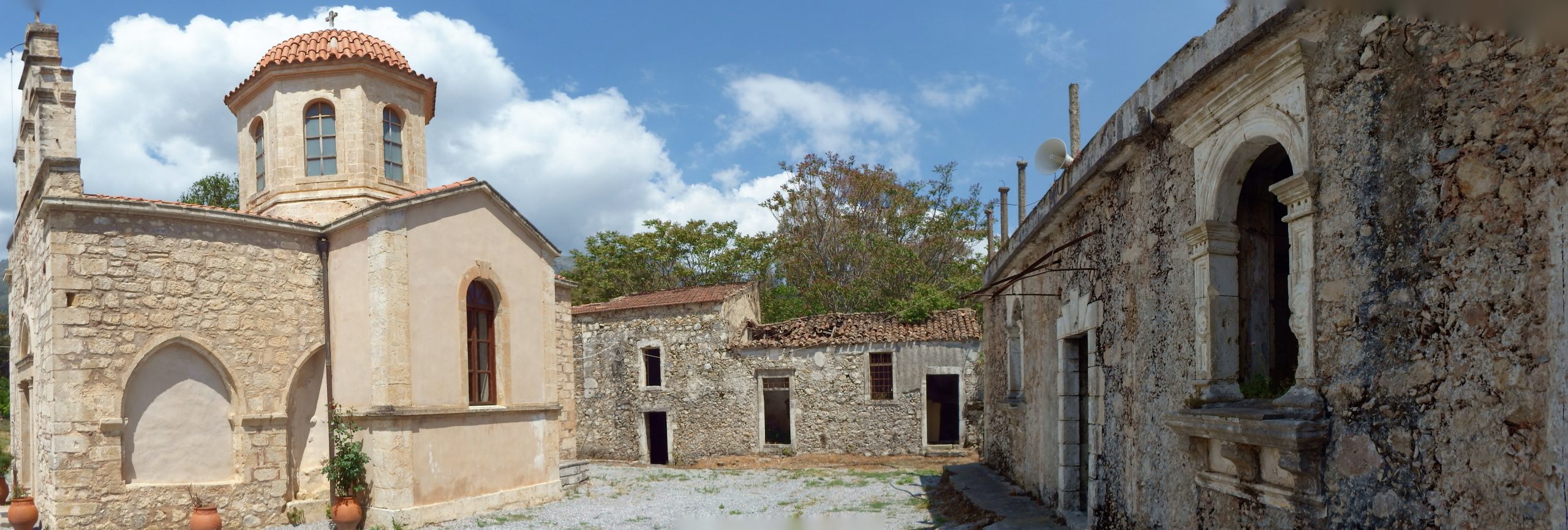
On the eastern shore of Lake Potami, the panoramic road runs along the 200-meter line, past Pliocene slates, marls, and limestone to the west, then turns north until, after a three-and-a-half-kilometer drive, you leave the shore behind and climb through a wide valley up to the small village of Pantanassa at 450m altitude. After driving six kilometers from the lake, one reaches the pass at 565m altitude on the north flank of Mount Angathi [1.091m]. In a fast drive you rush down from the pass on a lonely road, over the village of Apostoli on a plateau, to the district capital Agia Fotini at 478m altitude, with a small market, health center, gas station and post office. At the outskirts of the village, the road branches off into the valley towards Amari.

Here the grandiose panorama of the gardens, olive groves and vineyards of the Amari Valley opens up, which this tour travels through in a small circle. The NW-SE trending graben zone is bounded on the east by Tripolitza limestone of the Psiloritis Massif, on the south by Mount Samitos with mainly Pindos limestones, and on the west by Mount Kedros with Pindos limestone and Pindosflysch. A series of valleys and gorges stretch from the mountains to the Amari Basin, which ensure the good water supply and the special climate of the basin in the protection of the mountains. The Platis River drains the Amari Basin to the south and empties into the sea at Agia Gallini.
Lined with oaks, maples and poplars, the road descends to Asomatos Monastery, shaded by plane and tamarisk trees. At the entrance stands a row of palm trees with large, fanned leaves. Dating back to the 12th century and a brief period as an agricultural college (1927), the buildings are in various stages of disrepair, apart from the well-preserved cross-domed church in the center.
The cyclist travels in solitude. There is no traffic since the turnoff into the valley. Through a short avenue of pine trees at the monastery you drive straight north to Monastiraki. Vineyards, extensive olive groves and cornfields line the way. In spring, the meadows shine in the most beautiful colors, dotted with yellow and red poppies, red and blue anemones, tulips and morning glory.
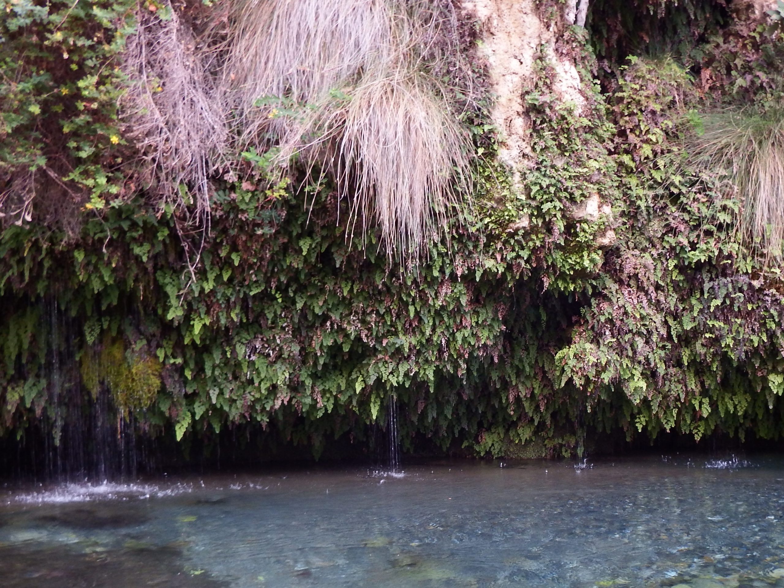
A murmur and whisper of a small brook, the banks covered with maidenhair over whose leaves drops of water trickle like small pearls. Magnificently oleanders shines with red and white umbelliferous flowers. Reeds stand on the shore. Neighboring grows the monk’s pepper or chaste tree with small stone berries and a peppery taste, the Judas tree with pink flowers and myrtle. The storax bushes adorned in white, cistus, wild flax and irises shine like a rainbow over the cool ground. Welcome to the realm of the water nymphs.
The wealth of the valley is reflected in the vegetable and fruit crops. Apples and oranges, figs, peaches, and cherries ripen into a sweet, powerful taste. Also famous for the variety of sheep and goat cheeses, which are produced here. The soft Midzithra, the Tyrozouli and Anthotiro cheeses, as well as the spicy hard Graviera and Kefalotyri cheeses are highly recommended.
With steep ramps, the road winds up for seven and a half kilometers at a 5-7% gradient via Monastiraki, up the eastern slope of Mount Katsonissi, to the village of Amari. Below the village of Monastiraki you find the ruins of a Minoan palace from the old palace period.

Following the signs to Amari, the narrow road lead you up in tight curves into the now more barren landscape with Vineyards on calcareous soil and olive trees. Past the church of Agios Georgios you reach the hamlet Opsigias and further on the village of Amari with the impressive Venetian campanile. The spiral staircase of the bell tower leads to the belfry high above the village.
The slope decreases and soon the village of Meronas is reached with the Byzantine churches of Agios Nikolaos and Panagia, from the 13th and 14th centuries, respectively. The wondrous world of naturalistic wall paintings depicting the life of Jesus Christ and the expressive adoration of the saints unfolded an enchanting spell in the unreal light of the church. In the center of town, you find the opulent flowing karst spring, where the climbers can refresh themselves for the remaining kilometers to Rethimno.
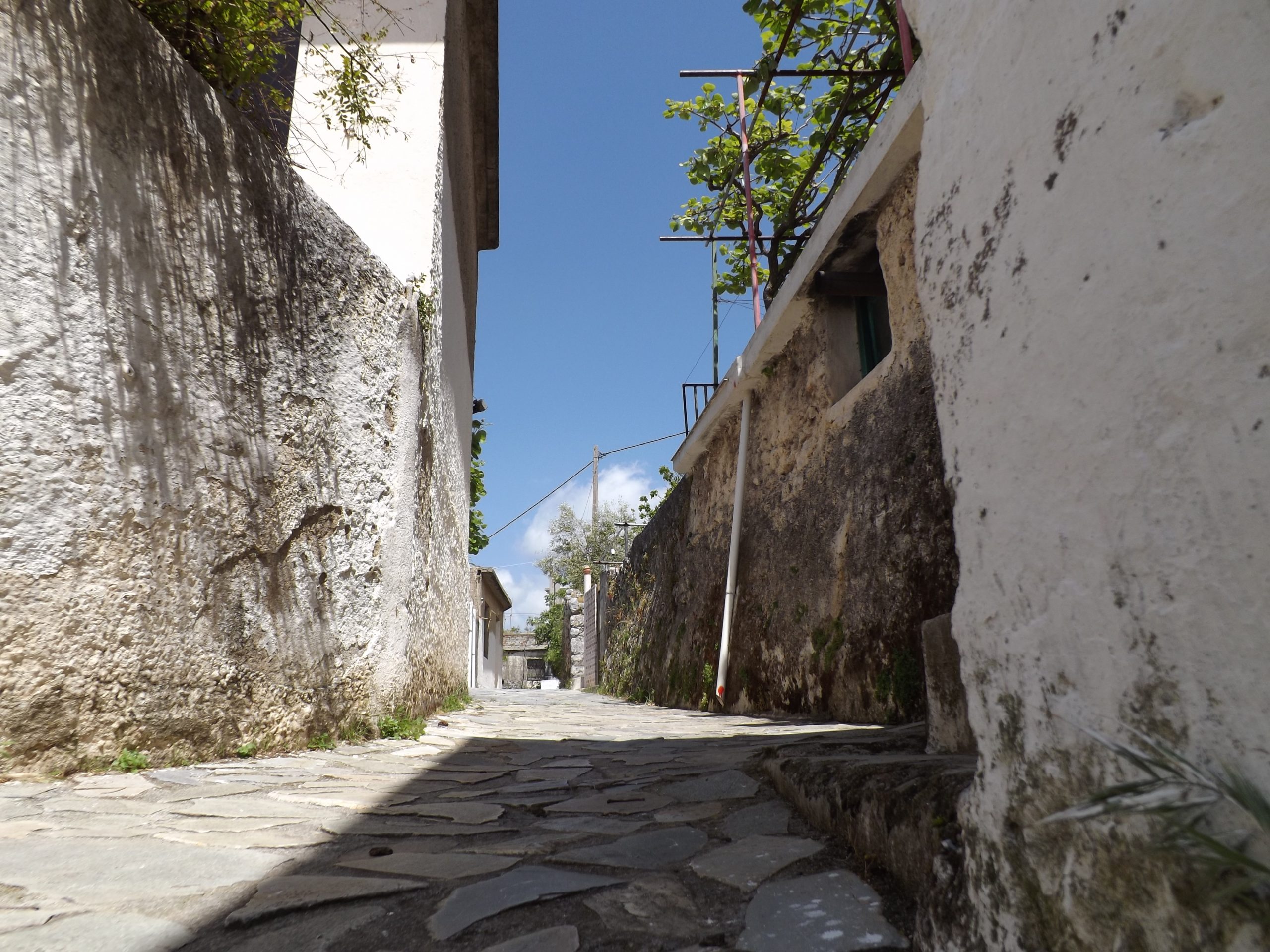
The road now leads nine kilometers downhill via the villages of Apostoli, Pantanassa and further above two hills to the 400m elevation line just before the village of Patsos. On the opposite slope, the mountain road winds steeply and in tight bends higher and higher to the village at 470m altitude, shaded by oak and plane trees. At the outskirts of the village, turn left in the direction of Spili. The road becomes a narrow band and meanders through the lush green bushes with a gradient of 5-7% and steep ramps at the northern flank of mount Soros [1.184m].
The Amari Valley lies deep below you as you climb through olive groves and extensive vineyards, the road embedded in the rocks of the phyllite-quartzite unit, higher and higher into the vegetation zone of the maquis. After five kilometers the pass is crossed at an altitude of 670m.
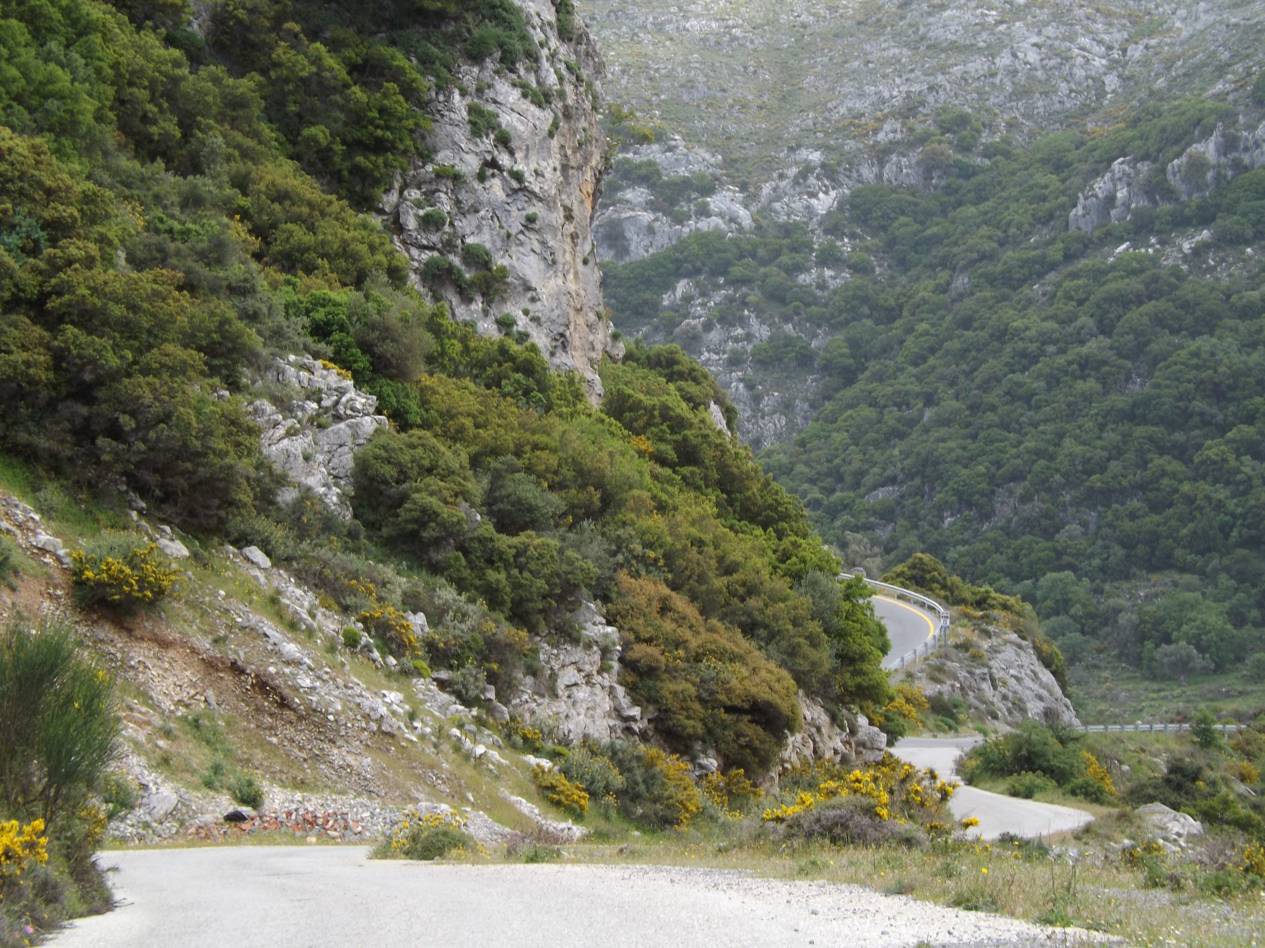
Through the magnificent scenery of the Kedros mountain you cycle four kilometers through slate and marl, over the mountain plateau and past the towering cliffs of the Pindos limestone, before a fast downhill on on a winding road towards Spili requires your full attention. After you have turned onto the main road to Rethimno at Spili, you can roll easily for another six and a half kilometers to the small hamlet of Atsiphaedes, before, on a route of five kilometers, you must overcome another climb of 270 meters in altitude. In the hilly terrain you have now the last sixteen kilometers under your wheels. Via Armeni it is a relaxed downhill ride to Rethimno and back to the shore of the Mediterranean sea.