


1.0 Chania- Meskla- Theriso- Chania | 59 km | 1.461 Vertical meters | Category 3
59 km | 1.461 vertical meters | Category 3
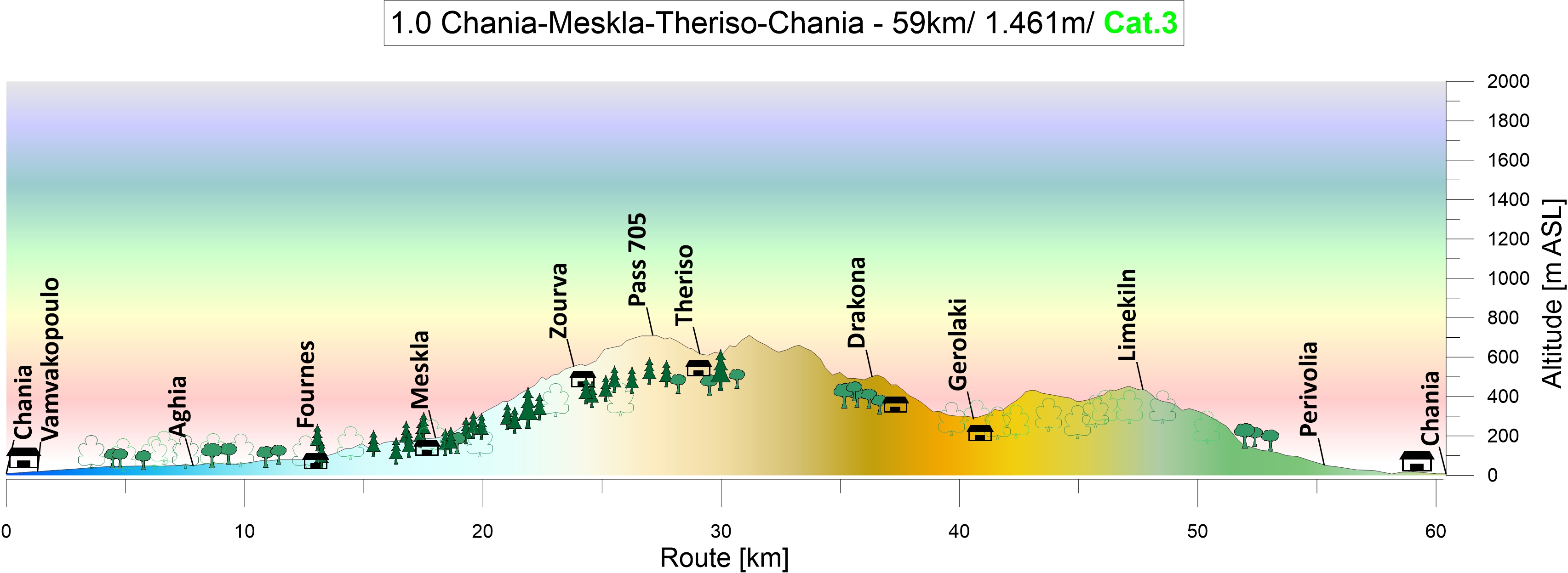
Up into the mountains to Theriso: Short of time? Leave the noisy atmosphere of Chania and Vamvapoulos behind for a morning ride.
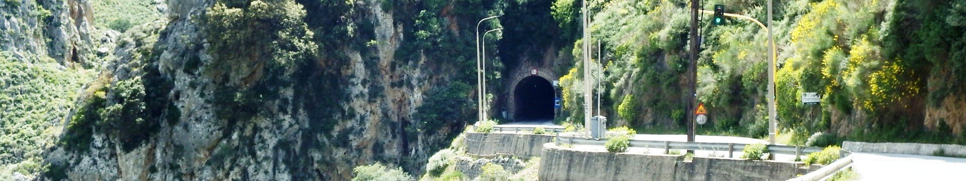
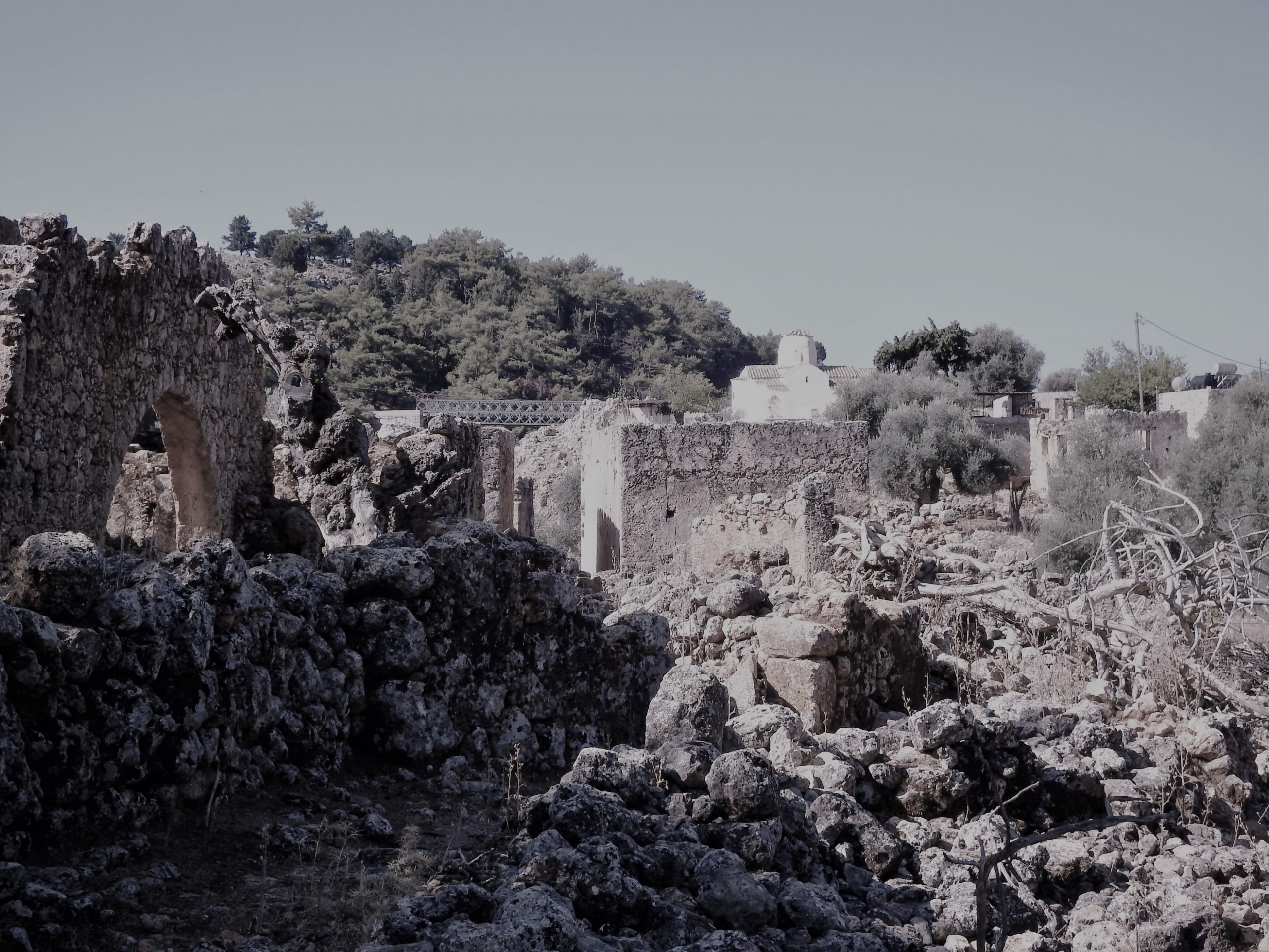
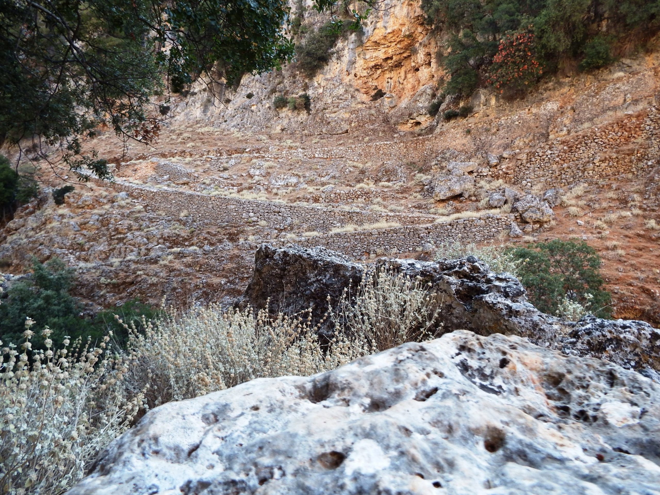
You pass through the gardens, fields and orange groves all the way to Fournes and the lush valley of Meskla. Here the Sotiros Christou church’s magical beauty, with its fading frescoes of Daniel and Michael Veneris, dating from 1303, will enchant you. Climb on into the alpine mountains, through Zourva and the upper outskirts of the village Theriso, via the vineyards of Gerolakos and Loulos and back through the romantic Theriso gorge. You will be back at Chania in time for lunch.


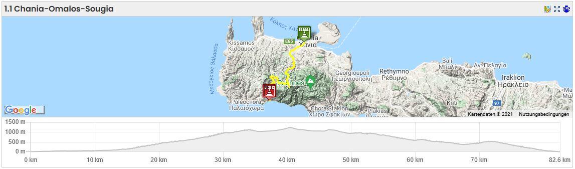
1.1. Chania- Omalos- Sougia | 81 km | 1.970 Vertical meters | Category 2
81 km | 1.970 vertical meter | Category 2

From Chania into the White Mountains and to Sougia: Sougia the ancient Syia, is an enchanted place on the south coast and a perfect spot for a base camp. From here, you can explore western Crete high above the coast. Day trips take you up to the north near Kissamo and Tavronitis, or to the magical cultivated landscapes of the Sasalos or Deres valleys, through chestnut groves and a sea of silvery olive leaves, along lush river banks, and back to the south.

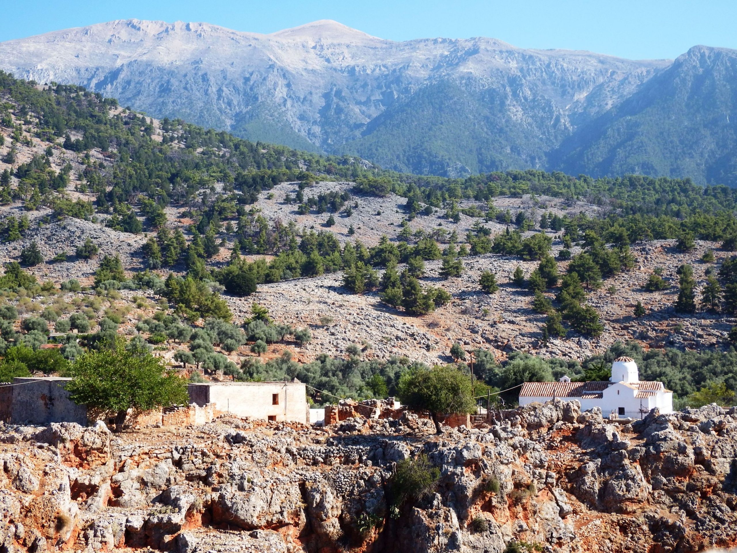
From the soft shapes of this hilly mountain area formed by slate, Cretaceous lime, clay and the sediments of the late Tertiary and Holocene epochs, a completely different Alpine mountain range of crystalline limestone rises up above the fertile ground towards the east, towering above everything else. The line of mountains is seemingly unending, ranging from the northwest to Sfakia in the southeast. Many of them are 2.000 m high and are covered in snow until May.
The White Mountains or Levka Ori with Mount Pachnes (2.452m) are broken up by lots of canyons from the north to the south and look almost like the mountain tops of the Arlberg, except that they are lined by pine trees and cypresses instead of oaks and maples.

The western side of these mountains can be reached on asphalt and features the Omalos plateau (1.100 m), an almost even basin covering about 25 square kilometers miles. It is full of fertile deposits resulting from the erosion process of the surrounding steep mountains. The first impressive tour takes you across the plateau and through the Alpine mountains from coast to coast, from Chania to Sougia or Paleochora.
You will pass the coastal plateau of Chania, the orange groves near Fournes. The road then winds through the Alpine mountains rising up to a level of 1.100 m. It leads through small valleys, past the landslide and up to the solitary pass. Once you have forced yourself through the chilly spring air, the fog, the rough wind and the rain below the top, everything seems to glisten beautifully.
As you break through the clouds at the top of the pass, everything is white, green and shiny on the plain, and the water from the melting snow drips in peaceful monotony. The sun is out while I rest in the small village. The friendly old folks at the tavern by the village boundary keep my company and gaze at me in amazement as I sip my hot coffee.
The average drop in temperature for every 100 m of altitude is more than 0.5 degree. With temperatures of 15° C/ 59° F at coastal level in spring and fall, this can mean temperatures of about 7°/44.6° F lower at elevated altitudes. Fingered gloves, a long pair of padded pants, fleece shirt, wind breaker and rain jacket are basic must-haves on such tours. In poor weather conditions, frost and snowfall are not unusual in these altitudes around early May.
Omalos is also the starting point for a hike through the Samaria valley that stretches out across 18 km. Access to the valley is near Xiloskalo, about 4.5 km south of and 200 m higher than the main village.

Bleating sheep give you a farewell, leaving the plateau on the southern border, left handed Aghi Theodhori, a small chapel at the pass (1.100 m), while you enter a unique valley surrounded by the alpine, cretaceous mountains overlooked by the Gigilios (2.116 m), Psilafi (1.984 m) and Trouli (1.454 m).

At the northern pass of this gem, it gets a bit windy and not so easy to hold the balance on the bike on the winding road to the junction to Aghia Irini and Sougia. Here, underneath the big wind power plants at about 800 m, you can easily enjoy the beginning of a fast ride to the southern coast and to the Libyan sea.
Keep an eye on the potholes that hide in the shadows at the roadside. Against the bright sunlight, they are hard to detect. Many a car owes them a flat tire or a broken suspension. In an involuntary crossing of such a ground, I could keep up with all the power the handlebar. But then a long search for the bike computer, the maps, the flip-flops and other loose parts was necessary.
Well sit back, if your sporting ambition allows such a posture on the bike and smell the scent of thyme and rock rose, while you are hurrying down the mountain with 50 kilometers per hour.
Fast impressions of a greening landscape, passing by olive trees, cypress, pine, maple and oak trees, mixed with the smell of a rotting carcass, hot asphalt and the heavy dust of blooming flowers, while you dive into warmer layers of air.
For all climbers salvation comes at Kambanos. For 4,5 km you can go out of the saddle to climb the last altitude differences of 150 meters. But take a short break at the fountain of Maganari Kambanos after the junction to Skafi. This delicious water is pure and clear, and strengthens the mind and body.
There are no wolves or bears in Crete, so you need only pay attention to the next signpost to Sougia. This can be found at the crossroad to Rodovani. So turn yourself to the left and toward the east, because here your longest roller coaster ride begins, about 10 km long and 500 meters altitude difference downhill on serpentine road. After passing through the village Moni there are only a few kilometers up the coast. But do not pull the home stretch into the town of Sougia, because there lurking evil street sleepers.
Accommodation – Sougia

Recommendation for the night at Chania: Eλia Palazzo Hotel, Theotokopoulou Street. The hotel is housed in an old mansion that was converted into a warm, hospitable, traditional hotel offering you a comfortable stay during your vacation. The hotel is situated in the alleys of the enchanting Venetian Port of Chania, 50 meters from the sea and 300 meters from the city centre. Now newly renovated, it has become quite colorful.
At Sougia: Captain George right in the center of town. Captain George is a charismatic personality who traveled the seven seas. He knows the highways and byways of Crete and can give you information for excursions and hikes in the area (Ag. Irini Gorge, Lissos). Captain George has also excursions and taxi boats. The hotel has a large, quiet and shady garden with flowers, lawns and trees, also a barbecue area for all guests. All rooms have a private balcony, bathroom (hot water at all times), air conditioning, fridge, kettle, double glazed doors and windows with mosquito repellent, safe.
2.0 Sougia- Chora Sfakion- Argiroupoli- Spili | 81 km | 2.385 vertical meters | Category 1
81 km | 2.385 vertical meters| Category 1

»And sailing down the side of Crete, as well as we were able, we came to a certain place named Fair Havens, near which was the town of Lasea. And as a long time had gone by, and the journey was now full of danger, because it was late in the year, Paul put the position before them, Saying, Friends, I see that this journey will be one of great damage and loss, not only to the goods and the ship, but to ourselves. But the captain gave more attention to the master and the owner of the ship than to what Paul said.« [Acts of the Apostles 27; 8- 11 / Paul on his journey to Rome]
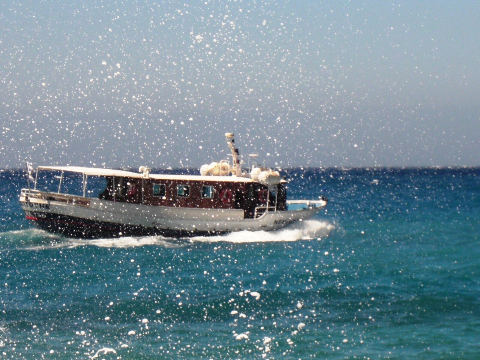
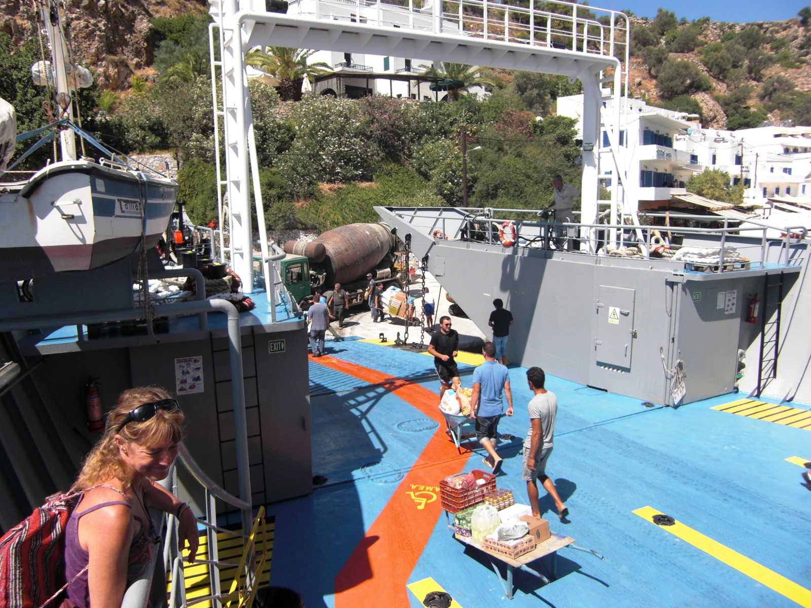
Only audible to those in the know, there is a soft humming above the waves that turns into a deep buzzing sound as the coastal ferry glides around the small cape near Sougia. The flaps of the bow ramp bang onto the pier and a short time later, you can step onto the vibrating deck of the «Daskalogiannis” or the »Samaria«.
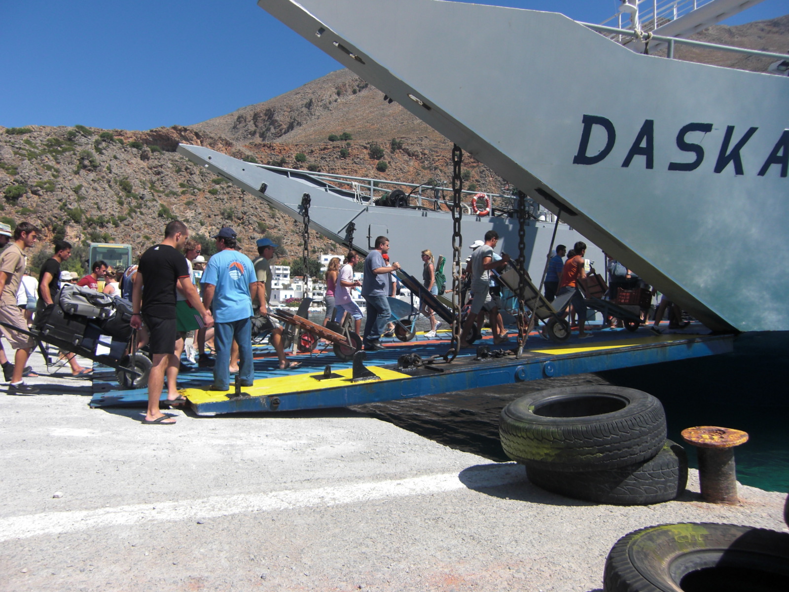
The ferry: Accompanied by the soothing sound of its 1.500 hp engines, the ferry begins to sway gently in the deep blue sea. The rocky coast rises steeply broken up by canyons, lifted up over thousands of years like the breaker zone at the shore. Little white beaches lined up like rare pearls on a string above the gleaming malachite and turquoise water.
But something is different today. There is no humming, no buzzing, just a little ship sitting there. It looks almost shy and bashful because it is so much smaller than its big loud sisters that usually attract all the attention here. As the Lord of the Sea has protected the little ship so far, its owners named it »Neptune« in gratitude.

The travelers look puzzled, but the friendly captain waves and invites them to board »Come aboard! Yes, this is the ferry to Chora Sfakion – it’s a good ship!« The smile fades from his face for a longer moment as he sees the bike, and his skeptical look reveals the hardship of a seaman’s life. But we soon find a space for the bike between crates of tomatoes, onions and bottles of toilet cleaner. No problem at all.
»But after a little time, a very violent wind, named Euraquilo, came down from it with great force. And when the ship got into the grip of it, and was not able to make headway into the wind, we gave way, and went before it.« [Acts of the Apostles 27; 14- 15]
And so it happened that the journey came to an untimely end in Agia Roumeli, where the majestic Daskalogiannis took the stranded voyagers on board and escorted them safely to Chora Sfakion.
From here a challenging climb starts, following the winding road uphill, into the mountains of the Sfakia region and to the villages of Asfendou, Kallikratis, Asi Gonia and the magical fountains of ancient Lappa and Spili.
For the next 15 km, the road cuts in steep curves into the barren slopes of the crystalline limestone, and then ascends to a pine forest whose scent and the sunbeams peeping through the branches give the rough landscape an enchanting feel. It is a pleasure to master this varied ascent and to climb turn after turn parallel to the mountain slopes.
Just outside the village of Imbros there is a right turn to Asfendou in the east that takes you even further up to an altitude of 1130m. At 21 kilometers along the route, a little detour on an asphalt road is definitely worthwhile. It takes you to the peak of Mount Akones (1.243m) where you can see a weatherbeaten radio antenna framework from an abandoned listening post and enjoy a terrific view across Crete, ranging from the silvery sea along the southern coastline to the barren peaks of the mountain range at Sfakia.

In spring, this mountain region can be rather cold and foggy until May. Temperatures may be as low as 0°, so make sure to bring warm clothes and rain jacket.
But when the sun comes out, you can see the houses of Asfendou peeping through the green down in the valley and the road winds gently downward along the slopes of the little plateau – all the way to Kallikratis.
Once you leave Kallikratis behind you, there is a shortcut that saves you 11km. Turn right if you want to try this alternative route in the direction of Vilandredo and Spili.
But come on; let’s get some rhythm on this. Things will speed up considerably if you choose to proceed in the direction of Argiroupoli! Leaning into the road bends, getting out of the curve with speed, hit the brakes, set the rhythm and dive down steeply in this scary hairpin bends of the Giparis gorge for about 400 vertical meters.
Proceed through authentic Asi Gonia, the local centre of sheep farming and cheese processing, until you reach the green valley.
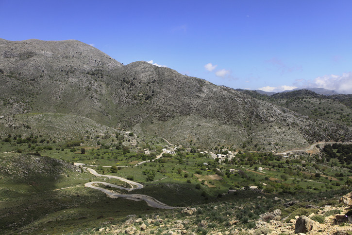
Oak, chestnut and sycamore trees line the road, and there is a sweet smell of violets. Rest for a while, enjoy the calmness, and listen to the dripping and gurgling sound of the brooks that are abundantly covered with vegetation. This watery valley is surrounded by the up to 1.500m high Sfakia Mountains. It’s a truly unique experience.
If you need a break and some food, there is a tavern under the sycamore trees near the car park in Asi Gonia that I can recommend. Argiroupoli also offers a great range of places to stop for a bite to eat.
When you cross the bridge near Argiroupoli and go past the roaring springs and the upper part of Lappa’s old town, which used to be an important town in Mycenaean and Roman times, you’ll face another ascent. The route means a 400m altitude difference and will take you through a fertile hilly landscape with corn, olive and sheep farms until you reach Velonado and Kali Syktia.

After 60 km of endurance riding and a 1.600m altitude difference, you can enjoy the last 20km to the full. From now on, you’ll continually go downhill on a varied road and experience the typical landscape features of Crete.
Olives, grapes, oats, fig and almond trees, and blooming gorse by the roadside accompany you on your way through Agios Ioannis, Paleoloutra, and Agios Vasilios until you reach the turnoff to the main road to Spili. And, sure enough, Spili shortly comes into view from the south western side of Mount Kedros.
Spili is a typical, lively Cretan mountain town and has a community administration centre, health centre and, as it is the domicile of the metropolitan bishop of Lambi, also has a bishop’s see with a seminary.
After a final 100m ascent, you ride into town past the seminary, and reach the centre with a famous Venetian lion fountain dating from the 16th century. Its cool and fresh water is simply delicious.
Accommodation

Argiroupoli – Agnaterma, at the southern outskirts of Argiroupoli, offering en-suite balcony rooms, marvelous view of the valley and to the coast. Tavern with delicious food, situated at the large terrace in front of the house. Clean rooms, central kitchen, excellent living and eating.
Spili – Pension and Tavern Costas Inn, on the main road shortly before the center. Clean rooms, some with fridge and a quite garden (with a choir of singing birds) at the rear of the house in direction to the Kedros Mountains. Breakfast in the morning and delicious food is been served at the tavern and on the terrace in front of the house. Storage and service of the bikes is possible in the basement at the left side of the house.

2.1 Sougia- Chora Sfakion- Vrisses- Kournas Lake- Argiroupoli | 63 km | 1.725 vertical meters | Category 3
63 km | 1.725 vertical meters | Category 3
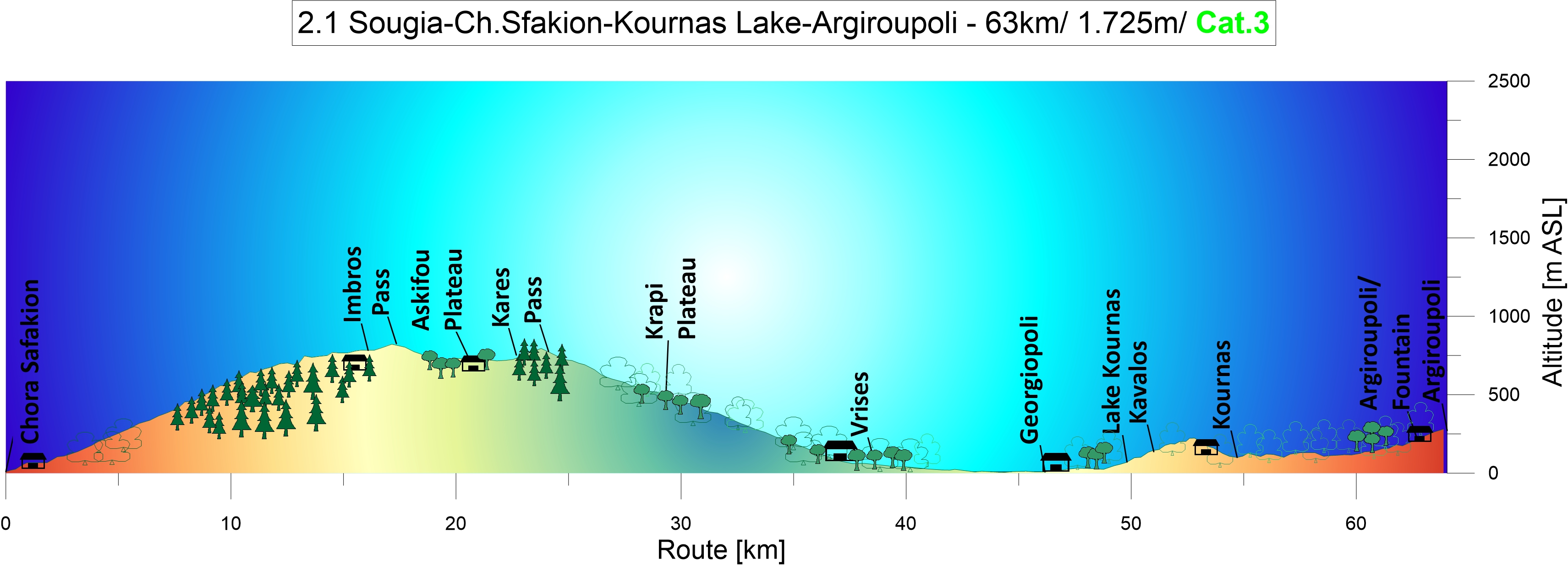
From Sougia to Argiroupoli: I was seasick when I reached Chora Sfakion. After a rough crossing by ship from the west, I was happy to go ashore. Showered by the spray from the waves on arriving, I did not even felt refreshed and had only one desire: I longed for a difficult mountain stage.
The road with its steep ascents up to the Askifou plateau went forth and back again in a way I had never encountered before. It turned sideways in steep turns, and finally made me throw up my frugal breakfast, just when a cheerful crowd on a jeep safari drove past me. From now on I inhaled deeply the surrounding scent of pine on this breathtaking climb up the serpentine road to the plateau.
Explore the fantastic mountain scenery, going over the pass at 890m and straight to the main village Amoudari, surmounted by the distinctive cone of the Kastro (2.219m). Karst mountain ranges typically feature potholes and closed basins (poljes) that look almost flat, but which are littered with debris caused by the weather scouring the surrounding mountain slopes, which enables the land to be used for agricultural purposes. Swallets (or ponors) allow the water that reaches the potholes to flow off below the ground, but if there is no drain, the plateau will turn into a temporary pond.

Climb the northern mountain ridge at 800m and speed up downhill to the water-rich village of Vrisses, situated under large sycamore trees. The friendly atmosphere invites you for a rest. Try the special Sfakion yogurt they make here from sheep milk.

The route leads through Georgiopoli to Lake Kournas, the only natural freshwater lake of Crete. Overlooking the wide water surface and the surrounding, up to 1.400m high Mt. Fourni, it seems as if you are in the high mountains. But the lake is located just 60m above sea level.

Now there are still 20km to go, until you reach the outskirts of the village Argiroupoli, the ancient Lappa. A unique mild and peaceful atmosphere lies above this place with its rushing fountains.

2.2 Sougia- Elos- Elafonisi- Sclavopoula- Sougia | 124 km | 13 km Dirt road | 3.164 vertical meters | Hors catégorie
124 km | 13 km Dirt road | 3.164 vertical meters | Hors catégorie


Through the Selino region: Enjoy this adventurous trip through the splendid green Selino region with its capital Kandanos. Proceed to Elos, located among magnificent chestnut trees, to the famous monastery of Chrissoskalitissa and Elafonisi beach with the finest coral sand and tall juniper trees.
Challenge your body and engage your mind on the adven-turous route back over the washed-out dirt road through the deserted landscape from Elafonisi to Sklavopoula.
After a relaxing downhill to Paleochora you have to face a strenuous climb, via the villages Azogires, Achladiakes and Strati, until you ride over the pass back to Sougia.

2.3 Sougia- Kisamos | 85 km | 2.140 vertical meters | Category 1
85 km | 2.140 vertical meters |Category 1
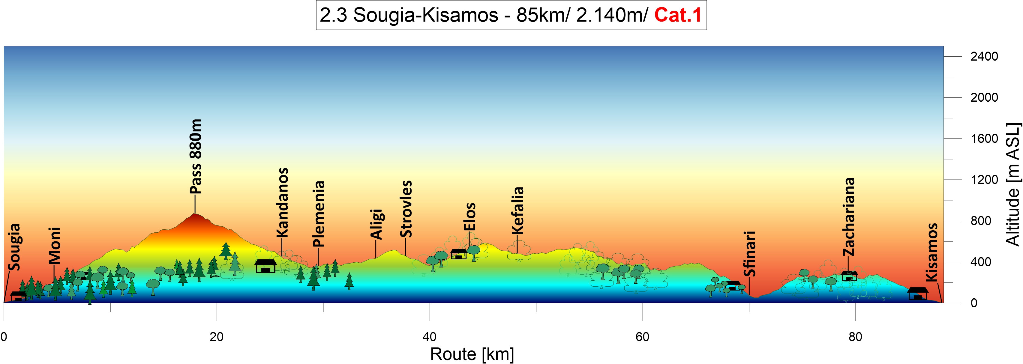
From Sougia along the west coast to Kissamos: Leaving the green valleys of the Selino region, you travel high above the western shore of Crete, through the barren and rugged landscape of mountains and high valleys.
Every bend offers new fantastic views of the azure water and the gently swaying, partly inaccessible coastline deep below that is incised by steep protruding cliffs. It’s an uphill and down dale ride, you eventually meet the northern lowlands at Lousakies near ancient Polyrrhenia, while they roll out the red carpet for you at Kissamos.

2.4 Kisamos- Sougia | 80 km | 1.709 vertical meters | Category 2
80 km | 1.790 vertical meters |Category 2
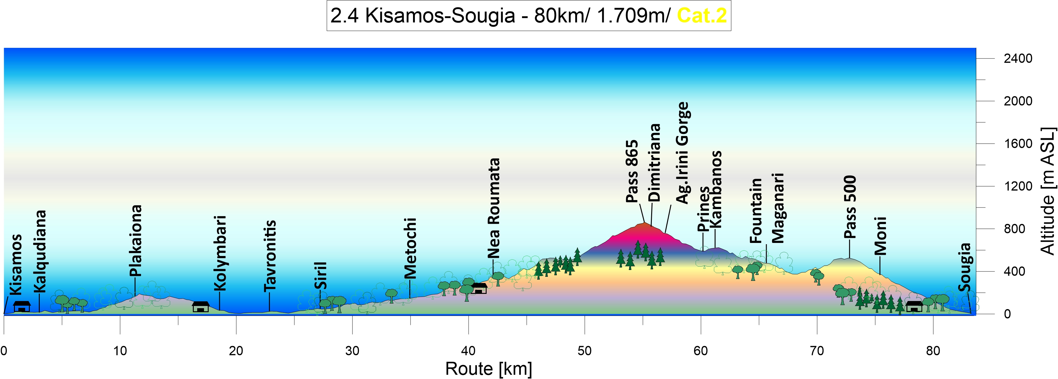
After a hearty breakfast your legs are ready to move mountains. Heading south along the red soils of the Kissamos area, you will once again come across lush and shady valleys with olives and vineyards.
Silvery leaves rustle and rush in the wind and you can hear the sound of the gurgling water. If you’re lucky, you might even get a glimpse of the merman at the small waterfall, playing his flute. The Silvery Route.

2.5 Sougia- Paleochora- Moustakos- Sougia| 98 km | 2.727 vertical meters | Hors Catégorie
93 km | 2km dirt road | 2.727 vertical meters | Hors Catégorie

The rolling hills of the Selino range: Ready to take it up a notch? This challenging ride will push your heart rate right through the roof!
There are four peaks to climb. First of all you cross the pass in the direction of Paleochora. From there, the road winds uphill through the lush and shady valley of the Pelekaniotikos River in the direction of Voutas and Moustakos. Pine and oak trees line the road and you’ll see flashes of white and yellow branches along the way.

A small detour on a partly unpaved road to the peaceful village of Moustakos is worth your while for a break at the bubbling brook. The varied mountain route then takes you uphill and high above the tree line into inhospitable and barren heights, where even the paved road seems to fade away.
Allow some time to enjoy the view over the beautiful Selino range with its rolling hills deep down in the valley. A green sea of olive trees seem to stretch all the way to the horizon. And well, these mountains on the horizon you still have to cross on your way back to Sougia.

2.6 Sougia- Prodomi- Sougia | 78 km | 2.239 vertical meters | Category 1
74 km | 4,6km dirt road | 2.239 vertical meters | Category 1

Up into the mountains and to Prodomi: Let’s take you on 4-hours ride into the mountains of the Pelekanos municipality. Climb up to the pass at 800m, via Rodovani, Papadiana and Strati and marvel at the spectacular mountain scenery and the sea view on your rollercoaster ride downhill to Paleochora.
In the center of town, turn left in direction to „Camping Paleochora“ and to the village Anidri.

It is a climb of 750 vertical meters up to a barren plateau, sometimes hidden in the fog and to the mountain village Prodomi, where the 4,6 km long track on unpaved road begins. The road winds dramatically along the steep slopes; sparsely covered with macchia, rock rose and kermes oak. You’ll reach the small mountain villages of Platanos and Asfendiles and dive down again on asphalt in the green valley of the Azogirianos creek, where you can refresh yourself at the watering hole between humming bees and wasps.

2.7 Sougia- Sasalos- Sougia | 82 km | 2.221 vertical meters | Category 1
82 km | 2.221 vertical meters | Category 1
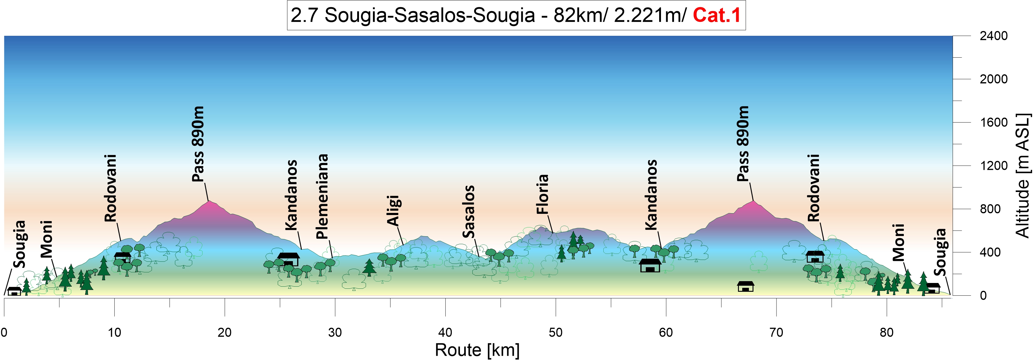
Through the Selino region to Sasalos: Take a ride through the rolling hills and the changing landscape of the fertile Selino region. Enjoy the climb to the villages of Rodovani and Temenia, up to the pass and downhill to Kandanos.

From there the ascent is moderate until you reach the small village of Aligni where the junction leads to the beautiful Sasalos Valley and the Milonofarrago gorge.
The road follows the gurgling brook, through copse of chestnut trees and sycamores. The banks and rocks are covered with grasses, herbaceous plants and ferns. At the center of Sasalos, a right turn leads into the wooded hills and in direction to the villages of Maneriana and Selia.
The mountain track winds gently uphill to the mountain ridge, then via Floria downhill to the wide plateau with the lovely town Kandanos. Enjoy the fresh water from the well at the junction to Sougia. A New Zealand soldier donated it to the people of Kandanos.

3.0 Chora Sfakion– Anopoli– Ag. Ioannis– Chora Sfakion | A Story Of A Vendetta
A Story Of A Vendetta
So I ran him through with my bronze-tipped spear as he came,
back from the fields. I lay in wait of him at the roadside
with one companion. A dark night obscured the sky:
Nobody saw us. Unperceived, I robbed him off his life.
(The Odyssee 13.167-70; Homer – A New Translation By Peter Green; University of California Press, 2018)
„Nemo me impune lacessit“
In the all-hiding shadow, leaning against the rough limestone masonry, the murderer lay in ambush. The death of the Big Geórgios was decided. On his way from the alpine pasture through the pine forest, in the dust of the road to his village, he would face his fate. He pushed the long barrel of his rifle through the crack in the wall, carefully considering the position of the sun, so that no reflection of the metal would reveal his hiding spot. It was a family affair. More precisely, a redress for the shed of blood, between his family and Geórgios‘ family.
There were no laws for Geórgios. He stood in the shop that was just a long corridor with a door, stuffed to the ceiling with everything the village needed. At first, he was indecisive, almost shy, but then he stuffed the nuts, the bread, and the wine into his shepherd’s bag, and left – without a word and without paying.
When the old owner faced him, Geórgios just grabbed him by the shoulder and pressed him onto the chair by the cash register where the cheese was cut and the owner always kept a knife. Until one day when the owner took the knife which was only suitable for cutting cheese but not for an attack. Poor old man – Geórgios seemed to embrace him but he stabbed his shepherd’s knife through his back and into his heart.
The Old Man trembled, like a thin tree does when a large saw separates its stem from its roots in just a few strokes, and when Geórgios released him from his embrace, he fell to his death.
Accompanied by lament, Geórgios stepped out into the street. And the lamentation turned into a scream, a cry that went from the shop to the street, from one to another, into the houses where they cooked, weaved and grinded – eerie and shrill, louder and louder, again and again: “Aristeídis is dead and there stands his murderer!”

They all rushed into the street and were now facing Geórgios.
He picked up a huge stone from the side of the road, like you carry a sheep on your forearms, rolled it into his hands, lifted it high above his head with a grim groan, and his figure grew into a giant, and he threw the stone into the crowd. In horror, dismay, and fear, they scattered in all directions and the stone rolled down the road.
Three policemen came from the mainland to investigate and interview everyone. Geórgios was acquitted in court because he had acted in self-defense.
The Story of a Vendetta: The devil turned into an eagle and rose from his eyrie at the gorge, high above the plain and the village where everyone was sound asleep. He spun strands as fine as silkworm threads and tied them to the sleeping people’s hands, feet, heads and thoughts, while the silkworms ate mulberry leaves with a quiet smacking sound. He pulled on one thread or another to check them and thought himself into their dreams.

The sun blinded Geórgios when he stepped out of the pine forest, and, walking across the karst surface, turned towards the village. When he reached the bend with the defile, a giant came up to him and punched him in the chest with his fist, so that he could not breathe. He struggled desperately for air, for when the bullet hit him and shattered his sternum, it also shredded his lungs and, emerging from his back, took a piece of his spine with it.
His legs still moved forward, while his upper body, torn backwards, crashed to the ground and fell into the dust. His legs buried beneath him in a bizarre contortion, he lay on the ground in a muddle, like scrawny pieces of wood, torn from the trees by a storm.
The Giants: Then the murderer stepped in and noticed the astonishment in Geórgios’ eyes, for the latter saw the giants from his mother’s fairy tales, the leviathans with frightening grimaces, long hair and beards, huge eyes, and snake feet, the monsters that Gaea, the earth, had born, and that tore him to the ground: Peloros, Alkyoneus, Porphyrion, Ephialtes, Eurytos and Enkelados. He saw himself, his mother, and felt – as he did in the past – the fear in the all-encompassing dark of the night, while the blood left his body.
The Time had come under enormous pressure, a book full of pictures in the dust of the path, its pages tangled, browsed and whirled around by the wind – then opened individual pages. He recognized his sheep and called all of them by their names, the patient, the timid, the blind and the limping one. He saw the faithful old ram, the beehives, trees and vines, the steaming milk into which he poured the rennet, the fat loaves of maturing cheese, the wick that he dipped into the hot wax to wrap it layer by layer, and the gold-colored honey flowing from the centrifuge as the oil from the press. Then the pages of the book came loose, crept under him, pushed and lifted him high into the air, then they throw him headfirst onto the floor, dead.
The Devil, though, took two earthen bowls and put them on a weighing scale. He poured Aristeídis blood into one of them, and Geórgios’ blood into the other. The old man’s blood was lighter than Geórgios’, so that the scales were out of balance.
The devil nodded, knowing that the people down there who lived next door to one another would now bring death to others in the village. At least two more had to die in order to bring the devil’s scales into balance.
For there were the beehives owned by Geórgios’ family, whose flight holes were sealed with clay, so that after a few days all the bees died, just like the vines in the vineyard of Aristeídis’ family, north of the mountains, which that had just started to blossom when someone tore them out by the root – a whole row of about 70 Vilana vines, now dried out and scattered across the hill.
The Goat Bell: The Bell that Aristeídis’ son had forged for his bellwether rang for the last ones the devil put in the balance before everything dispersed, as there were no men left to protect or kill. They had fled from the revenge of the others and from imprisonment, fled from the hard labor in the quarry, to suffer early aging and an early death – far away from the pastures, cattle and mountains, far away from their families. It was an enchanting bell, because its clapper was not attached to the bell’s bridge with an eyelet, as usual, but as a joint with a round head, anchored in a matching receptacle inside the bell body, so that the clapper could move around in all directions. And it did – striking against the wall of the bell body, it played a melody so beautiful that everyone stopped in amazement when the sheep came down from the mountains, back to the watering place and to be milked.

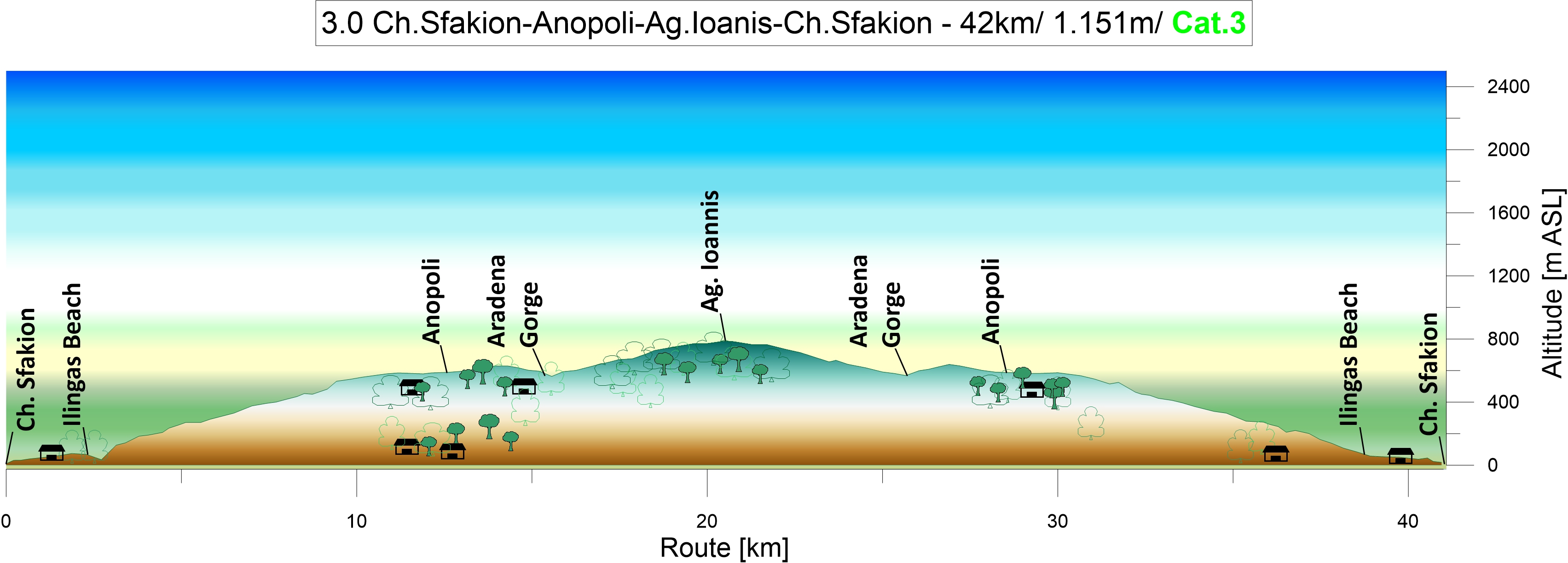
3.0 Chora Sfakion– Anopoli | 12 km | 900 vertical meters - The Mountain Time Trial
Mountain Time Trial | 12 km | 900 vertical meters

I could have burst into tears on this stretch of road, this increasingly steep gravel path that throws all the heat of the sky at us. … No breeze refreshes the glowing forehead, which has to bend over the handlebars over and over again, and can no longer believe that this mountain road will eventually end. … On the last switchback, my legs push into the dusty pedals like a machine, my body pushes the cranks around with its last strength, and it feels as if the narrow cranks were made of tough, liquid lead and no longer want to be pushed around … [Kurt Stöpel – Tour de France 1932, Verlag Harry Bartels, Berlin 1952; Covadonga Verlag 2004]
The Mountain Time Trial: Push yourself to new limits on this steep Mountain Time trial. I’ll hope that you are free from giddiness! First there is the salty smell and the rushing waves at the shore of enchanting Chora Sfakion, but then there are only barren limestone slopes, the serpentine road and bent guardrails which try to grab you with their iron-sheet-fingers. But this is just the beginning!

While you ride through Chora Sfakion, the road climbs steeply through the village towards Imbros and Chania. At the outskirts, just before you reach the medical center on the right, the road to the villages of Anopoli, Aradena and Agios Ioannis branches off to the left. Proceeding a bit uphill through narrow lanes, the road soon widens, and, with a gradient of 5%, follows the coastline towards the west. After two kilometers you cross the Ilingas Gorge in a wide U-turn. Then, after going uphill for another half a kilometer, you reach the bottom of the steep slope and the first bend of the time trial at 100 meters above sea level.
Nervously, my fingers move on the brake lever. The climb to the first hairpin bend is moderate, and so I dash into the steep inner curve much too fast. Parking cars block the way, people with parasols and beach accessories scurry past. They are on their way to the beaches in the west.

In an endless rocky desert of platy limestone, marl and sparse thorny bushes, the road now continues traverse to the slope and winds itself up to the second switchback at a gradient of 7%. Coming in through the wide and flat outer curve and with maximum acceleration on the straight, you climb a 400-meter path with a gradient of 11% up to bend 3. On the following two straights of 300 meters and 400 meters the route gets a little flatter until you cross the 200-meter contour line at curve 5.
Featuring four narrow U-turns (6-9) with gradients of up to 15%, the road is now carved into the steep slope. As you lift yourself up from the saddle, your silhouette dances on the road, following the winding path, curve after curve, steep section after steep section. Every grain of sand, every stone, every oil stain, every crack and every fragment of the road merge into a bright band that is greedily swallowed up by the shadow rushing on ahead of you. You have only completed six kilometers and reached 300 meters in altitude, but your legs are already burning from the extreme stress and high speed.

From the shadow in front of me a runner breaks free. Effortlessly, he sprints up the slope, the curves and the traverses with gradients of 5-7%. He turns to me and smiles. My breathing has turned into a moan, the heat rising from the asphalt has dried out my mouth, my tongue sticks to my palate, a sip of water drips from the corner of my mouth, and as if from far away I hear him shouting: “Go Nick, go!”.
It’s Dogan the boxer, my mentor if not Athena herself. He smiles, runs with ease, and pulls me along, faster and faster for the next two kilometers and up the counter slope to curve 13. The road now climbs towards the west in six sharp turns. The hairpin bends are connected by 200-meter to 300-meter straights with gradients of 5-8%. Standing up and going at a high cadence, I, too, climb effortlessly now. I lift from the saddle just ahead of the bend, and, shifting up a gear, I count and double the number of crank revolutions in the hairpin bends all the way up to the straights: 8, 16, 32, 64; then, I shift one gear down, and, back in the saddle, push forward with high frequency.

We are now face to face with Mount Kastri, because the road turns directly into the steep slope to the northwest and ascends to the big final on a 600-meter stretch with a gradient of approx. 12%. There is a short flat section, followed by the brutally steep ramps ahead of the 20th bend featuring gradients of up to 18%.
The mountain ridge with the pass and the antenna and power poles is towering high above the road, and you are well above 500 meters in altitude now. Nothing could be more delightful than to see the power cables leaning downward from the masts to the opposite side, an unmistakable sign that the pass is reached. Time to mobilize all your strength one last time. The path now turns downhill for some 250 meters, and at high speed you leave the 21st bend to manage the gradient of 4% on the 1-kilometer mountain sprint up to the plateau at 570 meters above sea level. Your body bent tightly over the handlebars, you go over the pass and get fast and faster for another two kilometers as you ride across the flat plateau. Fields, olive trees and orchards fly by until you happily reach the village of Anopoli in the karst valley at 580 meters in altitude.
3.0 Chora Sfakion– Anopoli– Ag. Ioannis– Chora Sfakion - Aradena and Aradena Bridge
Aradena and Aradena Bridge
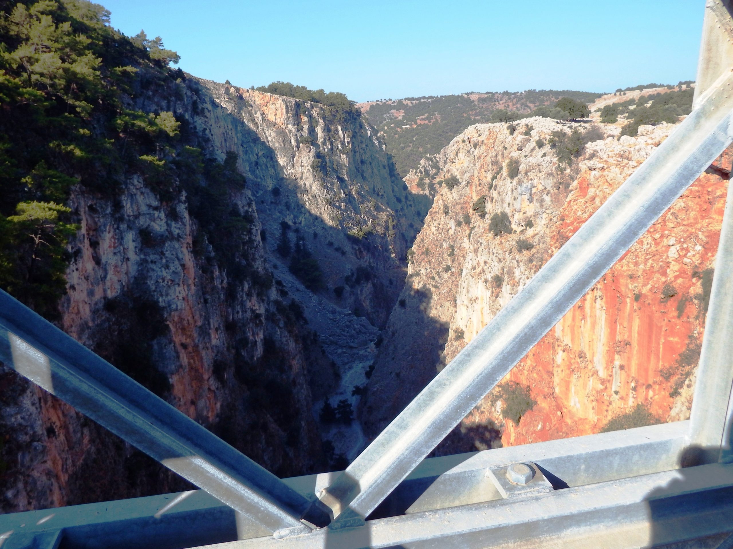
Aradena: With the snow-white peaks of the Lefka Ori mountains gleaming in the distance, the picturesque village of Aradena adorns the deep gorge. Just as brightly, the little white 14th-century church of archangel Saint Michael illuminates the steep slope. Built with ancient stones on the foundation walls of a Paleo-Christian Basilica, it was designed in the shape of a Byzantine cross. The interior is decorated with Byzantine frescoes and bears witness to the past, including the history of the city-state of Aradin, an ally of Pergamon in Asia Minor, which was once situated here.
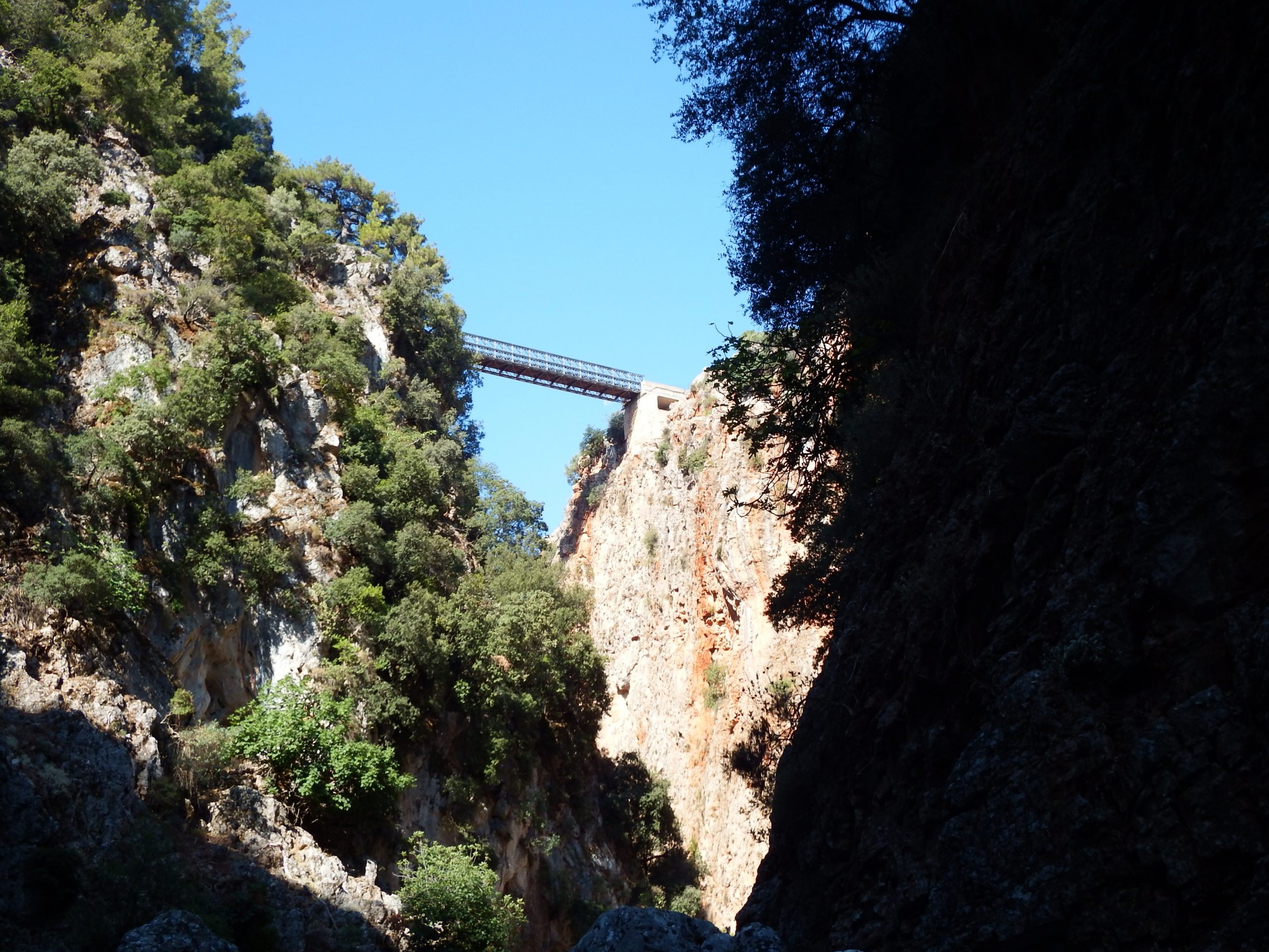
Aradena Bridge: The Aradena Gorge is spanned by a Bailey type truss bridge made of steel. Its supporting width is 84 meters, the length of the actual steel construction is 65 meters, and its height above the deep gorge is 138 meters.
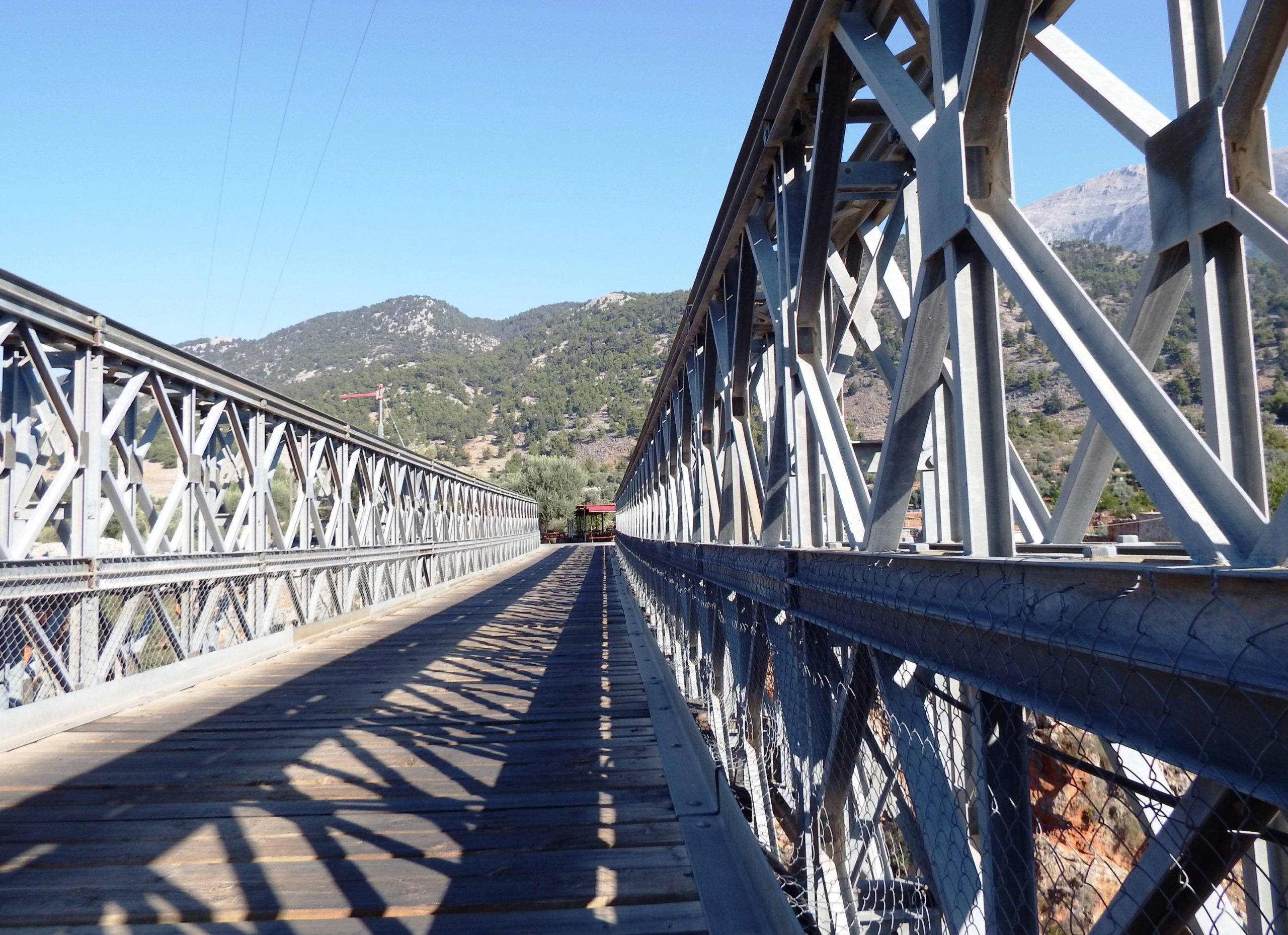
A Bailey bridge can be built from prefabricated standard truss elements without the aid of heavy equipment. It can be pushed over the obstacle to be bridged via roller bearings. You always connect so many bridge elements that the bridge can be pushed over the obstacle in balance or with a sufficient counterweight on the production side. To avoid a lowering of the bridgehead due to the bolt connections of the individual segments, an angular, upward-pointing “launching nose” in lightweight construction is applied at the foremost section, so that the bridgehead can safely be placed on the opposite bridge foundation. Instead of bolts, they used screw connections at the joints of the Aradena Bridge’s elements on the upper and lower chord, thus achieving a stronger connection of the individual segments and low deflection.
The 65-meter assembly line required to pre-assemble the necessary bridge length is still clearly visible today: It’s that straight section of road on the access side in the alignment of the gorge crossing. The unloading and storage area for the bridge elements used to be to the right of the assembly line.
Pavlos Vardinogiannis (1926-1984), a member of the Vardinogiannis family from the neighboring village of Agios Ioannis, initiated the bridge construction. His four brothers founded the Motor Oil Company in the shipping and oil business, one of the most financially successful dynasties in Greece. Pavlos Vardinogiannis studied law in Athens, was elected to Parliament in 1956 and became a minister in the government of G. Papandreou in 1964. After the coup and during the dictatorship he lived in exile. He returned to Greece in 1974 and was re-elected to Parliament in 1977.
Thanks to his initiative, the first gravel road link between Agios Ioannis, Chora Sfakion and the north of Crete was established, and with the financial support of his brothers, the bridge over the Aradena Gorge was built – in an area where goods were still transported on centuries-old mule tracks (Kalderimi) until the 1960s.
3.0 Chora Sfakion– Anopoli– Ag. Ioannis– Chora Sfakion - A Hike In The Aradena Gorge
A Hike In The Aradena Gorge
Welcome, dear audience, listen to the wind blowing through the gorge and rustling in the pines and oaks! Yes, the planking of the bridge starts its drum roll, this is the opening tune. Step into this spectacular and grandiose gorge. Tremble at the breakneck climbing sections, shudder at the sight of mummies and skeletons, marvel at the wonders of nature in the cabinet of curiosities – only here, in the Aradena Gorge!
The Aradena Gorge may be one of the lesser known gorges of Crete, but is all the more spectacular. So, take off your cycling shoes and slip into a pair of light trainers for a short and easy hike in the Aradena Gorge. When you stop for a break at the Aradena kiosk, it is advisable to ask the shop owner to store your bike inside his rooms. Under no circumstances should your bike be left unattended or without being well and safely locked.
The gorges, which are mainly cut into the limestone, were formed by the strong uplift of the mountains opposite the coastline, along a fault running from Chora Sfakion to Paleochora to the west. The gorges themselves were formed by drainage and karstic weathering along existing faults as well as by the fracture tectonics associated with this uplift of more than 500 meters, which has been going on since the late Miocene.

A Hike in the Gorge: Walk past the car park directly behind the kiosk and the ruins of the old oil mill on the western side of the gorge, then towards the north through the largely deserted village. When you approach the church and cemetery, turn left until you reach the gravel road running northeast. Follow it to the end of the village, where the paved mule track leads down into the gorge in narrow bends.
It’s shady and cool at the bottom of the valley. The soaring rock walls are up to 200 meters tall, and above the crypt, the bridge spans the gaping gorge at a dizzying height. Every rattle of a car crossing the bridge is amplified and echoes down into the mysterious silence of the underworld.
The walls of the gorge are cut into the sporadically overgrown limestone (Plattenkalk). At the bottom of the valley, where oleanders, pines and oaks adorn the slopes and the scree on the rocky ground, you can find thyme, sage, savory, chaste tree berry, lavender, oregano and capers, but also endemics such as ebenus cretica, linum arboreum with its yellow flowers or delicate ricotia cretica.

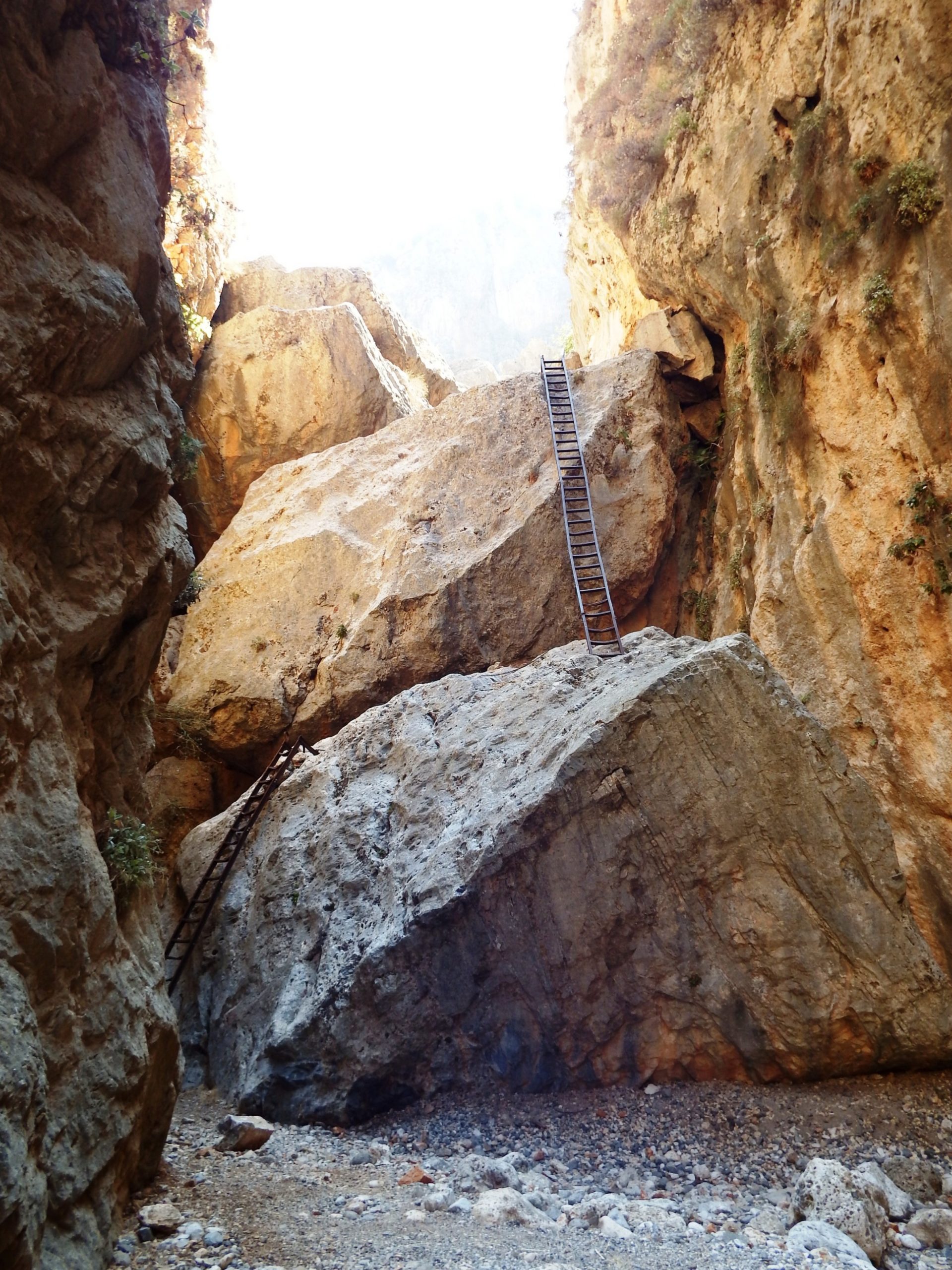
After half an hour of hiking, the first spectacular descent is reached via two huge limestone blocks that have fallen into the gorge. The descent of about 12 meters is made via two iron ladders (or, alternatively, by a walkable detour). In the past you had to hurdle this place with ropes and along an iron chain.
Proceeding coastwards, you’ll climb, slide and jump over some more large limestone blocks. Markings help you find your way, but are missing in some places, so you may have to climb back a bit from one or the other dead end.
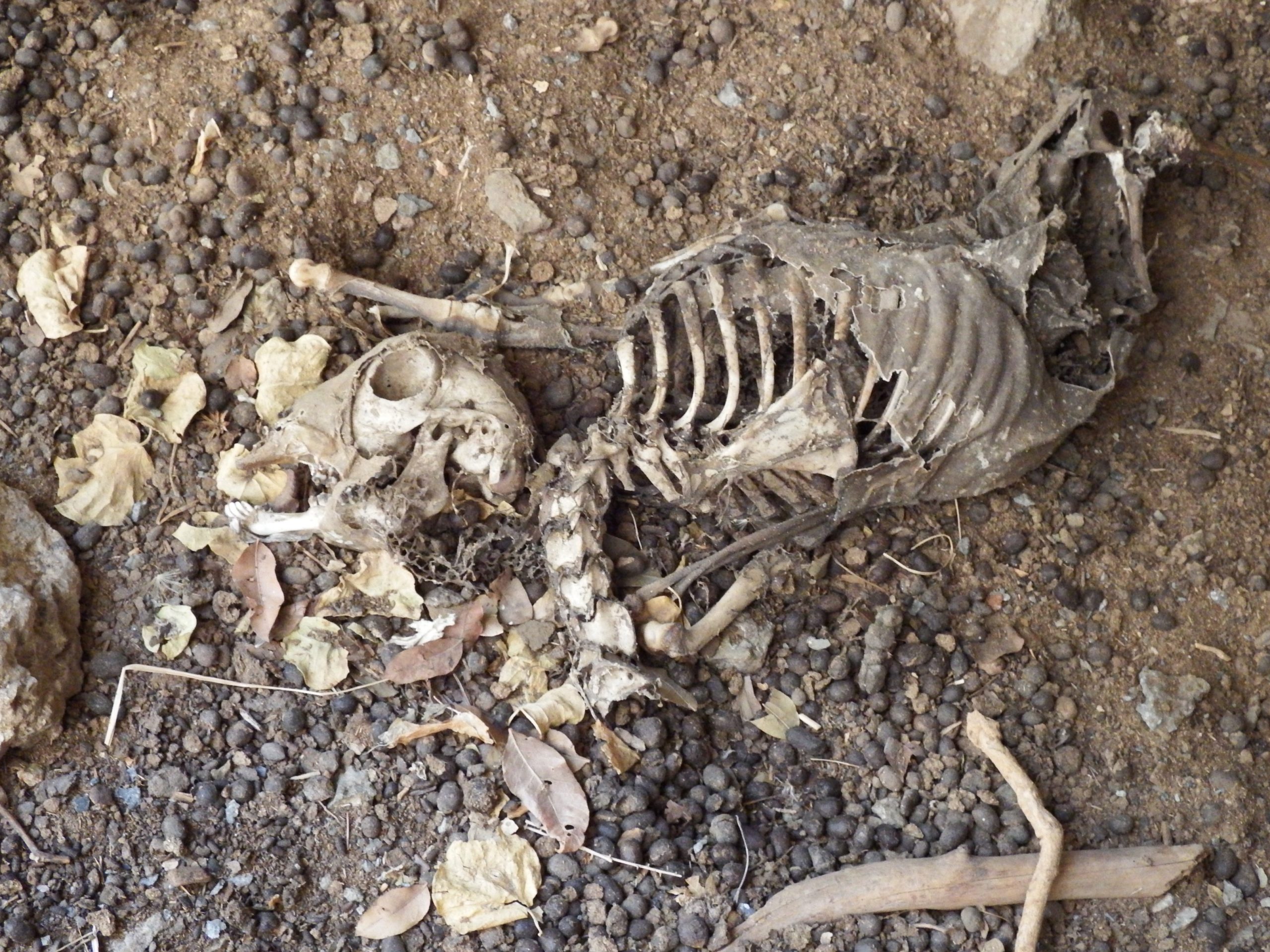
So … Bearded vultures circle already over the gorge in search of animal carcasses or a lonely hiker on a steep ridge in the middle of nowhere.

For those who know the way, the canyon hiking tour up to Marmara Bay takes approximately two to two and a half hours. The hiking tour through the canyon is definitely not suitable for children or people with a physical disability. I recommend that cyclists who wish to master the complete biking tour turn back shortly after the ladder passage.
As it can get extremely hot in the lower part of the gorge, sufficient water supplies are essential. You’ll be rewarded by the colorful marble grottos along the coast of Marmara Bay, into which you can easily swim from the beach.
3.0 Chora Sfakion– Anopoli– Ag. Ioannis– Chora Sfakion - The Tour To Agios Ioannis
The Tour To Agios Ioannis | 5 km | 200 vertical meters

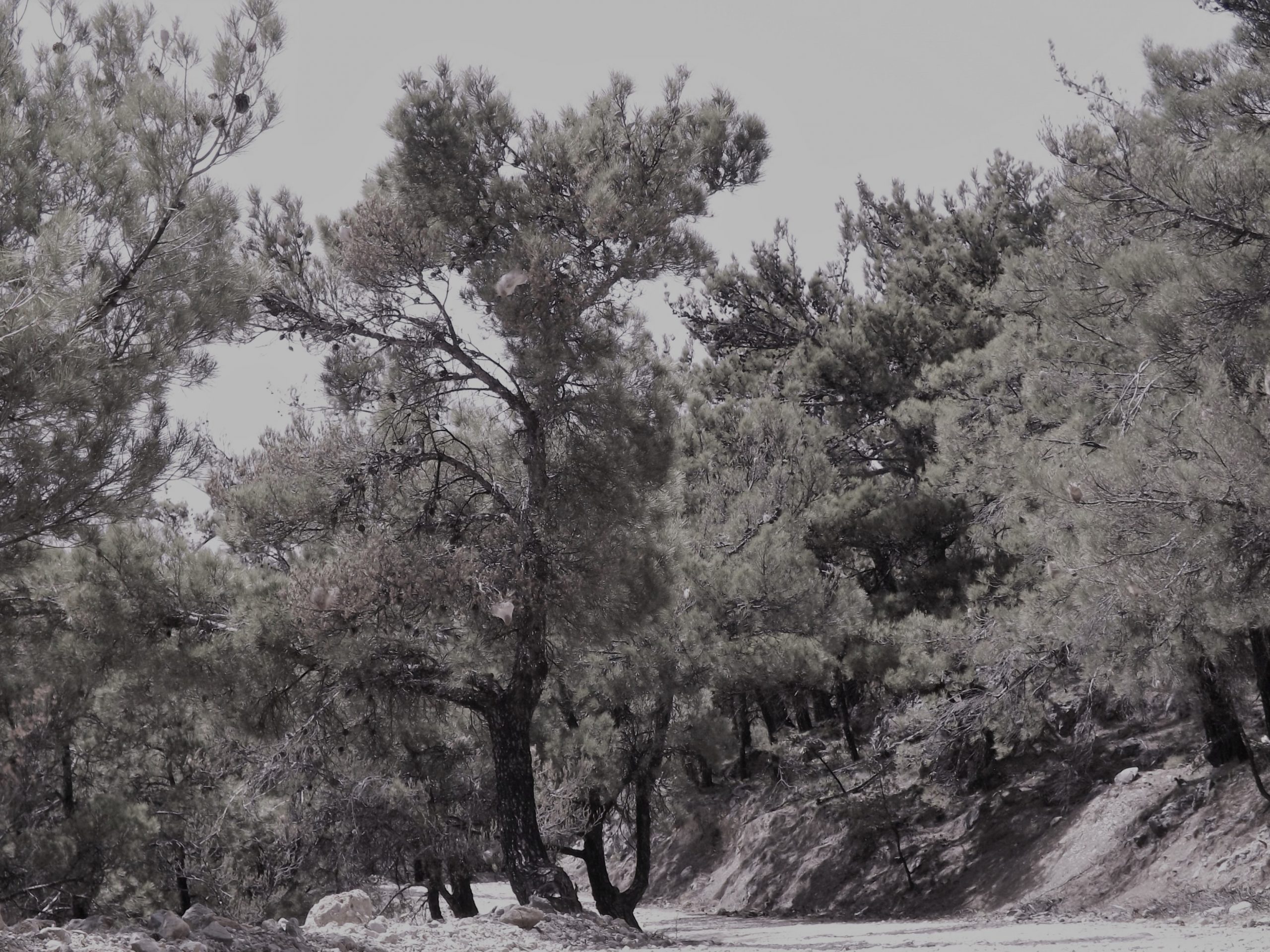
To Agios Ioannis: The weather has changed, fog rises up, and after crossing the Aradena Gorge you enter a completely different, alpine world. For five kilometers, the path from Aradena winds itself through a limestone scree dotted with juniper, rockrose, spurge (euphorbia acanthothamnos), herbs and grasses. There are still a few olive and cypress trees on the plain, and on the slopes a pine forest accompanies the road that ascends 200 meters in altitude while leading up to Agios Ioannis at 780 meters above sea level.
The karst valleys are adorned with green pastures featuring olives, juniper, wild flowers, herbs and grass. Here and there, pyrus spinosa, a very branchy wild pear tree shows off its glowing white blossoms as if to light the way and guide you through the fog.
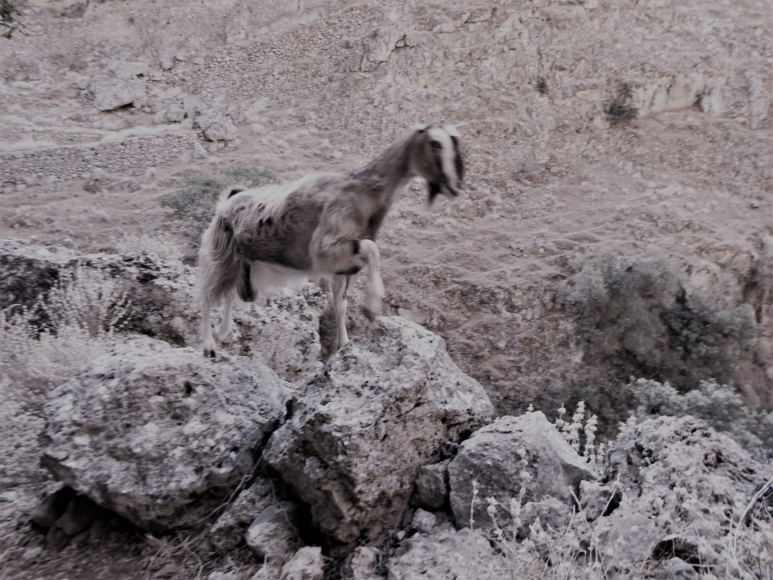
In the north, the barren Mount Kefala and Mount Koutska, still covered with snowfields, disappear in the clouds, and the warmth rising up from the road makes for a peculiar contrast to the cool wafts of mist from which sheep appear and disappear again like aliens. And just as suddenly the first scattered houses of the mountain pasture of Agios Ioannis emerge from the fog.
A Days Adventure: The 12-kilometer ascent to Anopolis, the three kilometers to Aradena, a three-hour detour into the Aradena Gorge, the five kilometers to Agios Ioannis, and the return journey to Chora Sfakion add up to an enjoyable and adventurous day trip of about seven hours, including breaks. In total there are 42km and 1,151 vertical meters to be mastered. Go for the adventure!
3.1 Chora Sfakion- Selia- Spili- Kalamaki | 103 km | 1.951 vertical meters | Category 1
103 km/ 1.951 vertical meters/ Category 1

Transfer stage to the south coast at Kalamaki: Celebrate your hard-earned achievements and turn your body into a machine on this hilly endurance ride on the transfer stage from Western to Central Crete.
From Chora Sfakion the road winds gently through the countryside and led up in turns to Selia and Mirthios.
The view up to the steep slopes and down over the wide bays is always great. Shortly after Asomatos, the road enters the wild Kourtaliotiko gorge. Here rises the river, which flows with rapid current through the gorge and enters the sea at Moni Preveli. So go again for the mountains on your way to Spili.
Climb through the alpine mountain scenery, the rugged gorge and through the green valley of Frati. The first part is really steep. The rocky walls stay closely together and rise directly into the bright blue sky. Spots of rock flowers and bluebells gleam into the shady gorge.
After leaving Spili and crossing the pass at 500m the road drops down in wide sweeping curves until it reaches the Gulf of Messara and the picturesque village of Agia Galini. So go on for Timbaki and at least enjoy the stay at the friendly beach-village Kalamaki, situated near ancient Agia Triada and Festos.

Accommodation
Recommendation for the night at Kalamaki: Apartment-Hotel Aglaia. Take the left fork of the main road at the village entrance. The friendly Charalambaki family offers comfortable appartements and double rooms, equipped with kitchenette and fridge, they make an ideal mid-range accommodation option. Shower and WC en suite. Web: https://www.aglaia.gr
