4.1 Spili- Gerakari- Zaros- Lendas | 109 km | 2.104 vertical meters | Hors Categorie
109 km | 2.104 vertical meters | Hors Categorie
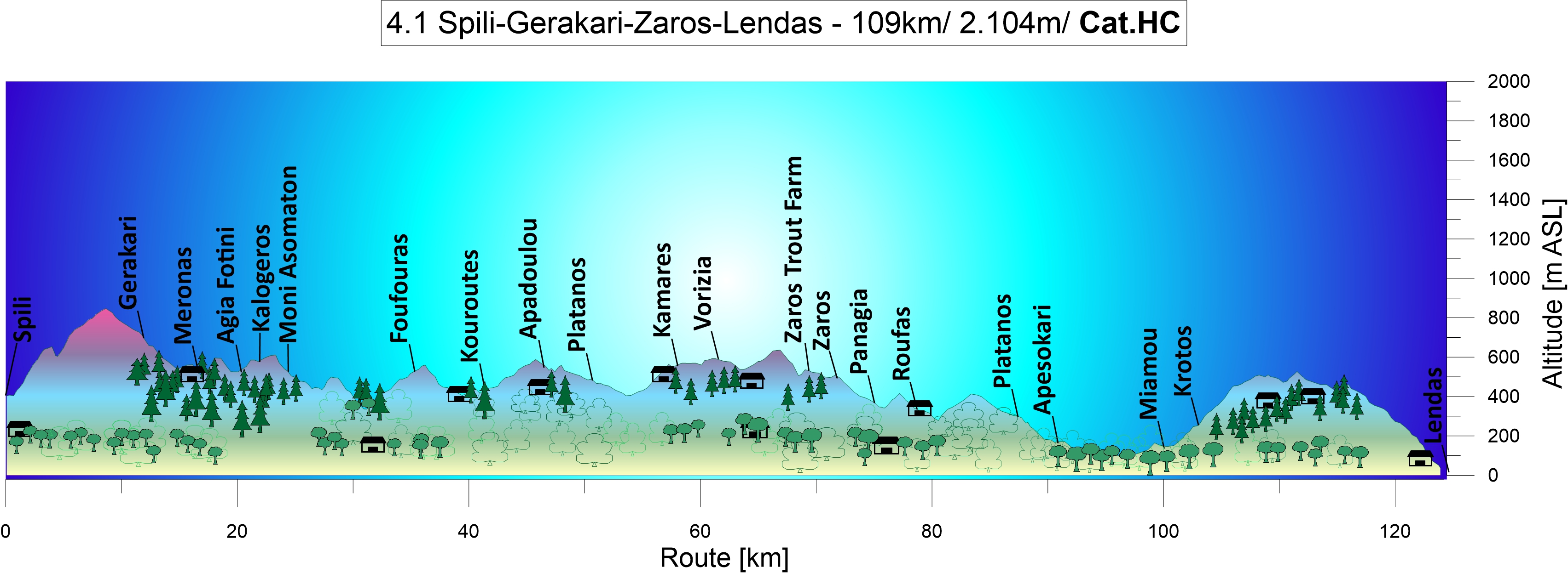
From Spili to the Amary valley: Coming from Thronos, you’ll go downhill past green farmland until you reach Asomatos Abbey. Take a short break to enjoy the silence of a spring day and listen to the water dripping and gurgling in the brooks that run through this lavishly green, moist valley. You will also see the snow-covered peaks of the Ida mountain rise up in the north.

The fertile Amari basin is located between the Levka Ori “White Mountains“ and the Idi Ori mountains. It is sheltered by the mountain ranges of Mount Sidherondas (1.177m) that stretch from the north-west to the south-east, as well as by Mount Kedros (1.776m), Mount Soros (1.184m) and Mount Samitos (1.100m), while Mount Katsonichis (1091m) and Mount Veni Korifi (740m) provide protection in the west.
The peak of Crete’s highest mountain, Mount Psiloritis (2456m), towers above them all. Unlike Mount Idi Ori and Mount Psiloritis, all these mountains consist of Mesozoic lithographic limestone. Small basins filled with sandstone and conglomerates of Tertiary flysch are dotted all around. Ride along the flanks of Mount Oros Idi to Zaros.

Zaros: Here you find Crete’s one and only trout farm, located in short distance above the town. There are several restaurants for a bite to eat and a hotel. In the shade of a cherry tree near the ponds, the rustling leaves lulled us to sleep. We dreamed of a hearty meal and were awakened by delicious scents.
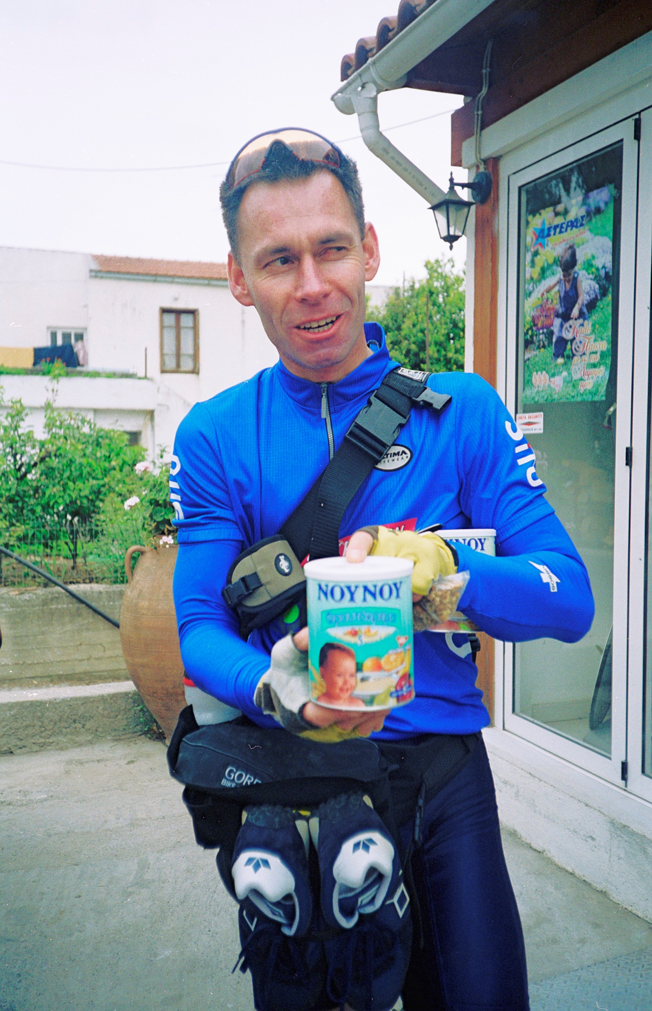
The feast: After five hours on our bikes and two litres of thinned baby rice as our only food, because we had run out of the all-important mixture of apple juice and diluted porridge oats, we feasted on Greek salad, bread and smoked trout, and we each drank half a litre of red wine. We still had 40kms left to ride and an altitude difference of 600m to manage before we reached the southern coast at Lendas. And therefore a piece of advice for you readers: never eat smoked trout on mountain rides! We had never felt so sick riding uphill. We had no energy left to ride and each turn of the wheel seemed to bring us closer to giving up and collapse than to reaching our destination.
Down on our knees: It was a nasty struggle against never-ending pain and agony. The dusk mercifully lent the cover of darkness to the pathetic moment when the two of us were down on our knees by the roadside. We did finally reach the pass in the end and dashed down towards the moonlit ocean, catching our breath again.
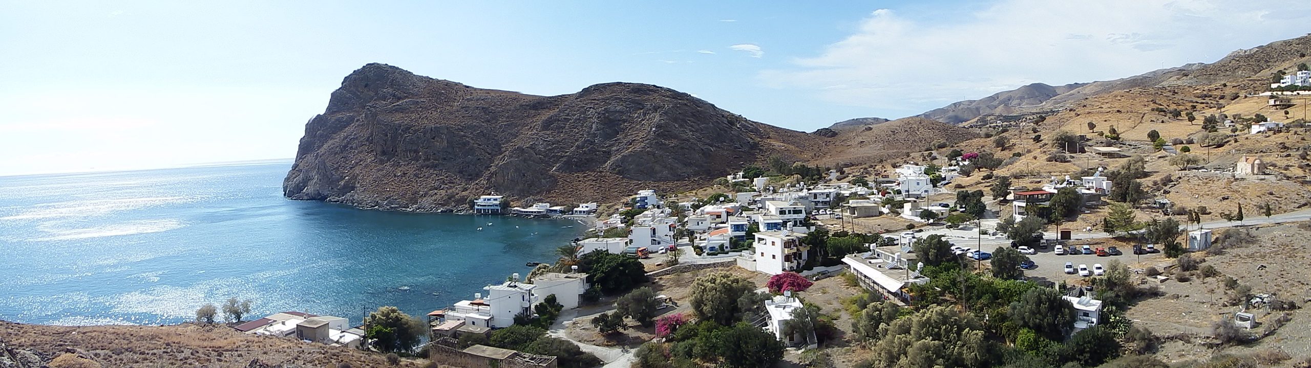
It felt like paradise when we arrived in Lendas, but the night had another ordeal in store for us: our intention was to travel light, which meant we had not brought our mosquito nets with us!
Asterousia mountains: On your way to the southern coast, you will pass the Asterousia mountains located south of and alongside the Messara plain which stretch from the west to the east. Ranging from Kap Lithino via Kali Limenis, Lendas and Kapetaniana to Tsoutsouros and Agioa Ioanis, the mountain chain is more than 50km long and reaches an altitude of 1.230m at Mount Kofinas.
Descent to Lendas – Go for the adventure: The road leading out of the Messara plain and over the mountains at Miamou and Krotos to Lendas is one of the most beautiful routes you can ride. From the pass, the road bends and rises up again to the opposite flank. You should try to conquer this in a sprint. The road will then suddenly reveal views of the wide ocean gleaming in the depth.
With your body bent over the handlebars, you glide downhill towards the water, taking turn after turn like a bird while the steep rock slope reveal nothing, not even the coast or a house. The town only comes into sight once you reach the last downward stretch near the dunes.

The geology of the mountains is very interesting. On the road leading down to the coast from Krotos to Lendas, you can see various forms of worn away metamorphic rocks, including amphibolite, quartzite, gneiss, sillimanite, granite schist, and mica slate. You can even spot ophiolites on the outskirts of Krotos and escarped granite intrusions along the track leading from Lendas to Kali Limenes. Lithographic limestone of the Tripoltiza unit forms the base of the massif. You will see it in the west, the south-east and at the southern coast. Palaeocene and Eocene flysch sediments with limestone and serpentine inlays follow towards the north. The region between Kali Limenis in the west and Lendas is characterised by a zone of distinctive metamorphosis with gneiss formation.