


10.1 Kato Zakros- Karidi- Chonos- Vai- Paleokastro- Kato Zakros | 92km - 106km | 5km Dirt Road | 1.859 - 2.204 Vertical meter | Category 1
92km – 106km | 5km Dirt Road | 1.859 – 2.204 vertical meters | Category 1

A dark, black cloud appeares above the church, a touch of a breeze then a treacherous push from a gust, wild and wilder, whirling up the red dust. Then worst, spreads to a red veil, embraces the lonely wanderer. He has to keep his balance, leaned into the wind, has to breath in this suffocating gloom, he must. The storm moves on as a whirlwind, slides faster and faster, keeps him trapped in an impenetrable cloud, bewitched by Prospero the Master.

The cliff of the Zakros Mountains towers imposingly above the east coast at Kato Zakros. Only a few gorges break up the harsh rocks such as those at Agia Irini, Xerokambos and Kato Zakros and further north at Hohlakies. Going through steep bends you ride from Kato Zakros into the mountains, climb up to the pass at 620 meters in altitude and to the plateau at Karidi. Here a wide, dry plain follows to the north, extending relatively evenly on approx. 600 meters in altitude from Karidi up to the small villages of Mitato, Krioneri and Chonos.
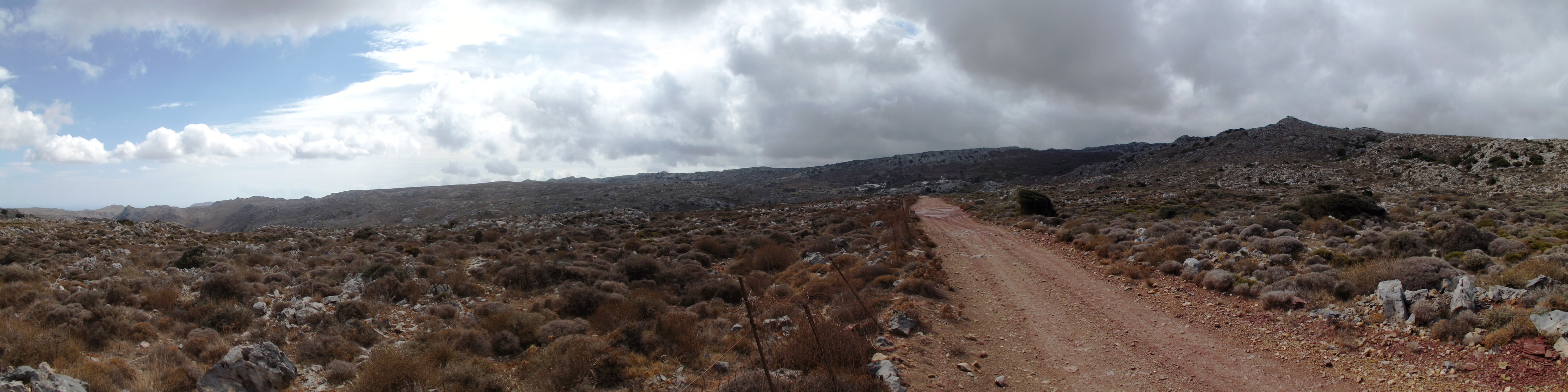
Karidi Plain: Gorges and large cave systems characterize this landscape of limestone and violet slate, a largely treeless plateau overgrown with round thorny shrubs of garrigue, the phrygana of Greece. In the dry summer climate of eastern Crete, with high temperatures and low precipitation, you can find the typical range of plants of the eastern Mediterranean around here – it’s a climate with predominant rainfall during the growing season of the plants in winter.
In spring, the prevalent yellow flower cushions of the round Greek spiny spurge (Euphorbia acanthothamnos) and the green thorny burnet (Sacropoterium spinosum) light up the landscape. Already flowering in autumn, the delicate and yet brilliant blue, towards the edge white blossom of Crown Friar (Globularia alypum) and the yellow flowers of Dwarf Jerusalem Sage (Phlomis lanata pygmi) can be admired.
Shrubby herbs such as red flowering Autumn Heather (Erica manipuliflora), the thorny, widely branched, and strongly aromatic Conehead Thyme (Corydothymus capitatus), Silvery Spurge Flax (Thymeleae tartonraira) with its silky hair, Greek Sage (Salvia fruticosa), Cretan Oregano (Origanum onites), St. John’s Wort (Hypericum empetrifolium) which looks like dry heather around here, and the delicate touch of pink of the small-flowered Rockrose (Cistus parviflorus) turn the plain into a landscape of simple, devout beauty in spring.
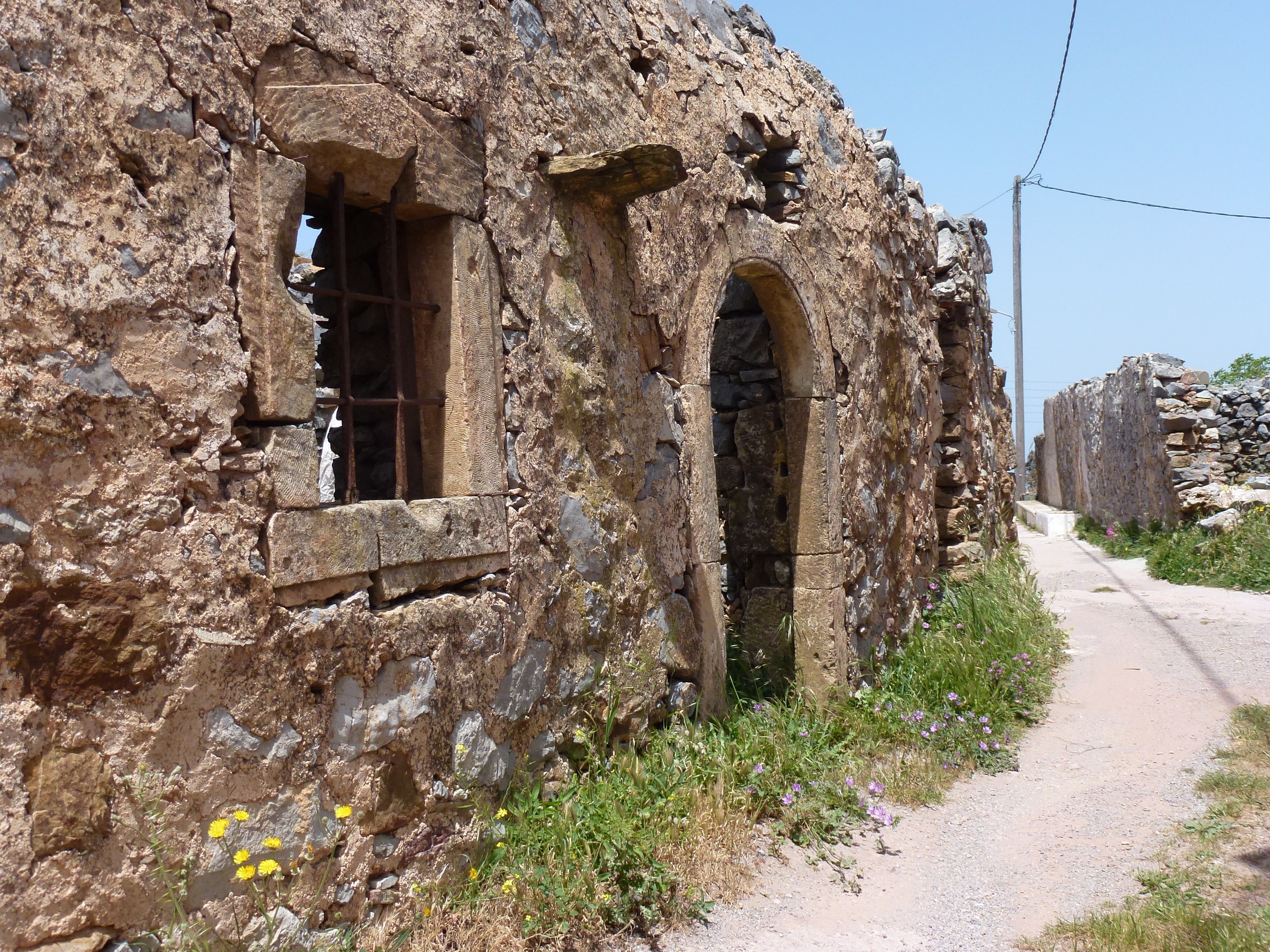
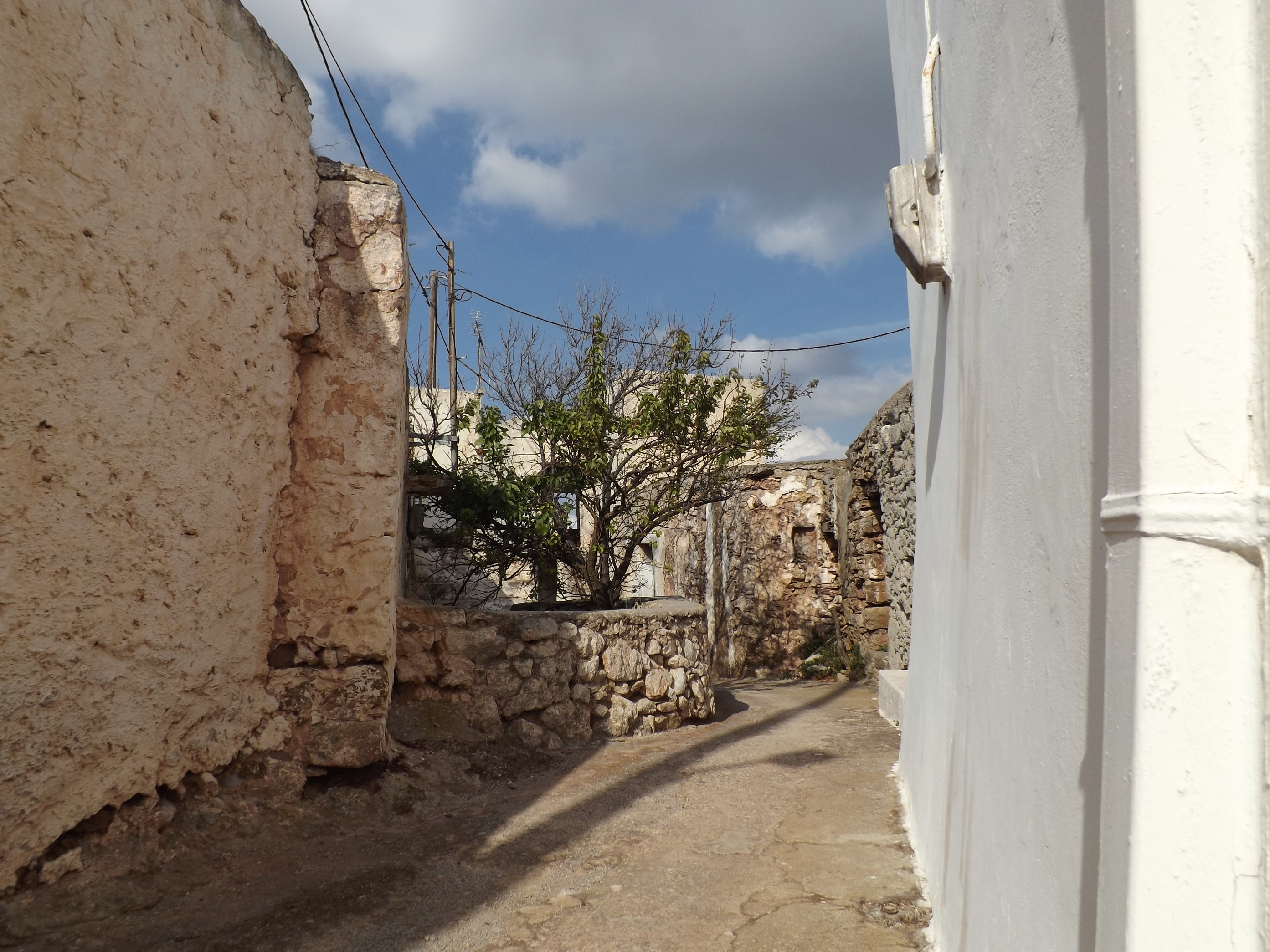
The Old Villages: If you stroll through the alleys of the picturesque mountain villages such as Karidi, Magkasa (Vrisidi), Mitato, Krioneri, Chonos or Xirolimni and let your hand rest on the old stone walls of the abandoned houses entirely build in rough stone, take a look at the frame of stonework around the arched doors and windows, and the heavy woods and beams supporting the ceilings and the roof. These beautiful and architecturally well-designed natural stone houses kept their warm brown tint and probably date back to the 16th and 17th century, the time of the Venetian and Turkish occupation.

The same is true of the paths from the Venetian period, which still connect the villages. You can admire them just outside Karidi, in the direction of Agios Antonios and Chonos, on Georoute 5 of the Sitia Nature Park and between Mitato and Magasas. Figuratively speaking, you can go back in time for five centuries while you walk on their pavement, absorbed in dreams and thoughts of the past.
High above these places, Bearded Vultures (Gypaetus barbatus) circle around like harpies, transforming the wide plateau, where sunlight is so pale today, into an enraptured, fabulous dreamlike backdrop. Dark clouds advance from the north, and suddenly there is a heavy downpour. In an instant, tiny rivulets turn into small streams that rush down from the flanks of the purple slate.
The Secret Machinery: Just outside Karidi, on the way towards Mitato, when my foot touched the dark red surface of the Violet Slate for the first time at the end of the concrete road, marking the entrance to the Karidi gorge, the landscape started to vibrate. It seemed as if my step had triggered off a hidden mechanism. Deep below me, hidden in the caverns of the earth, an apparatus had been set in motion which, like stage machinery, would determine the further events in a predetermined sequence. There was a dull rumbling that sounded like a train making its way on iron rails, followed by a rolling sound like that of rope pulls and drums, and a grinding of hooks which elevated pieces of the landscape, if not a complete gloomy horizon, from its subsidence, while at the same time high above the scene, shreds of clouds swept away in a ghost-like dance.

Emerging from the shadow of Mount Prassokefalo, I was now fully exposed to the stormy wind. I shivered. From here I overlooked the whole plateau. Immersed in the grey pale light of the approaching storm, a completely new, threatening scenery unveiled.
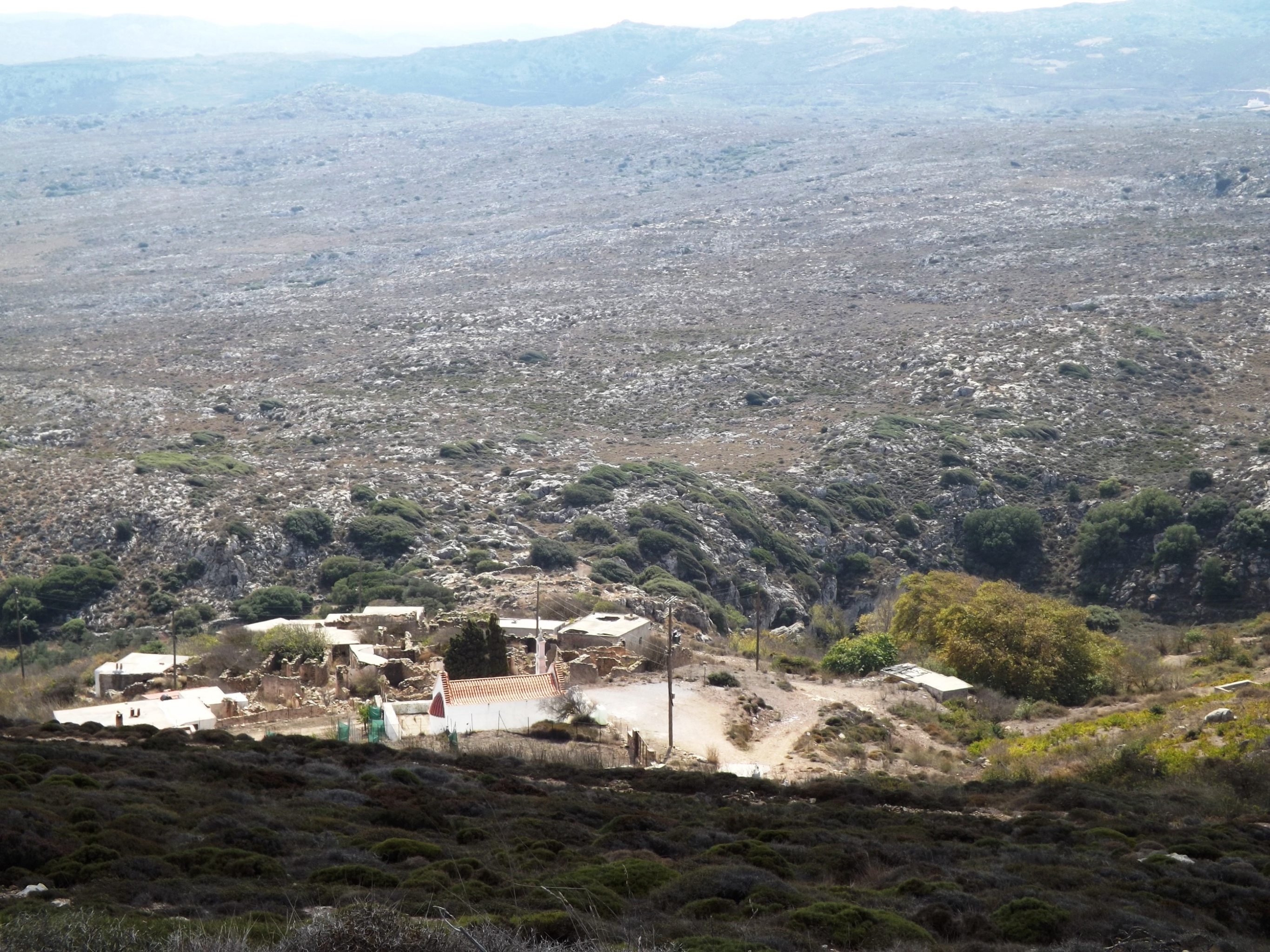
Storm: On the horizon, nothing but the little white church of Mitato and the whirling windmills stood out against the dark, ink- colored sky. Everything in this stage set appeared to be tense. It looked as if the sky was about to be torn asunder like a worn out piece of canvas, and turn everything – the dark red ground, the grey limestones, the columns of this world – into a stagger, an unstoppable gliding and whirling, which would inevitably have dragged me along into the abyss.

The vibration was a result of the wind, which had steadily increased shortly after the rain had stopped. Every thorn bush, every karst cavity whistling like an organ pipe in the rock, every fence post, every harp of wire mesh seemed to vibrate and filled the air with a singing sound that accompanied the storm orchestrally in addition to my rattling windbreaker jacket. Blowing constantly from May to autumn, there is a strong northwesterly wind from the Aegean around here, anyway – the Meltemi. But this was a storm.
For minutes on end the gusts pulled at me so fiercely that, despite my greatest efforts, it was impossible to brace myself against the wind, in order to get away and keep my bike, my backpack and myself in balance. The air seemed to have turned into a flowing liquid which makes a swimmer, who desperately tries to reach the shore against the back-flooding waters of the heavy surf at the coast, pitifully fail over and over again with every wave. Even the ground seemed to lose its firm consistency. My feet, supposed to prevent me from flying away like a shred of cloth, were my only connection to the surface of the Earth – but as I looked down on them, I realized how ridiculously small they were.
Mitato: The next place to provide shelter was the quarry ahead of the village Mitato, and I tried to get to it. When I arrived there after an exhausting hike – it was all over.

In the village itself, I spotted a pair of bright canvas shoes in the courtyard in front of a house. Immaculate, tidy and clean, they had been put there by their owner. Standing there in the sunlight, faithfully side by side, they were such a peaceful and tranquil sight, as if to deny the chaos that had just raged.
A whirlwind that had formed between the Ionian Sea and the Aegean Sea had swept across Crete, its ridges reaching wind speeds of 90- 100km/h.
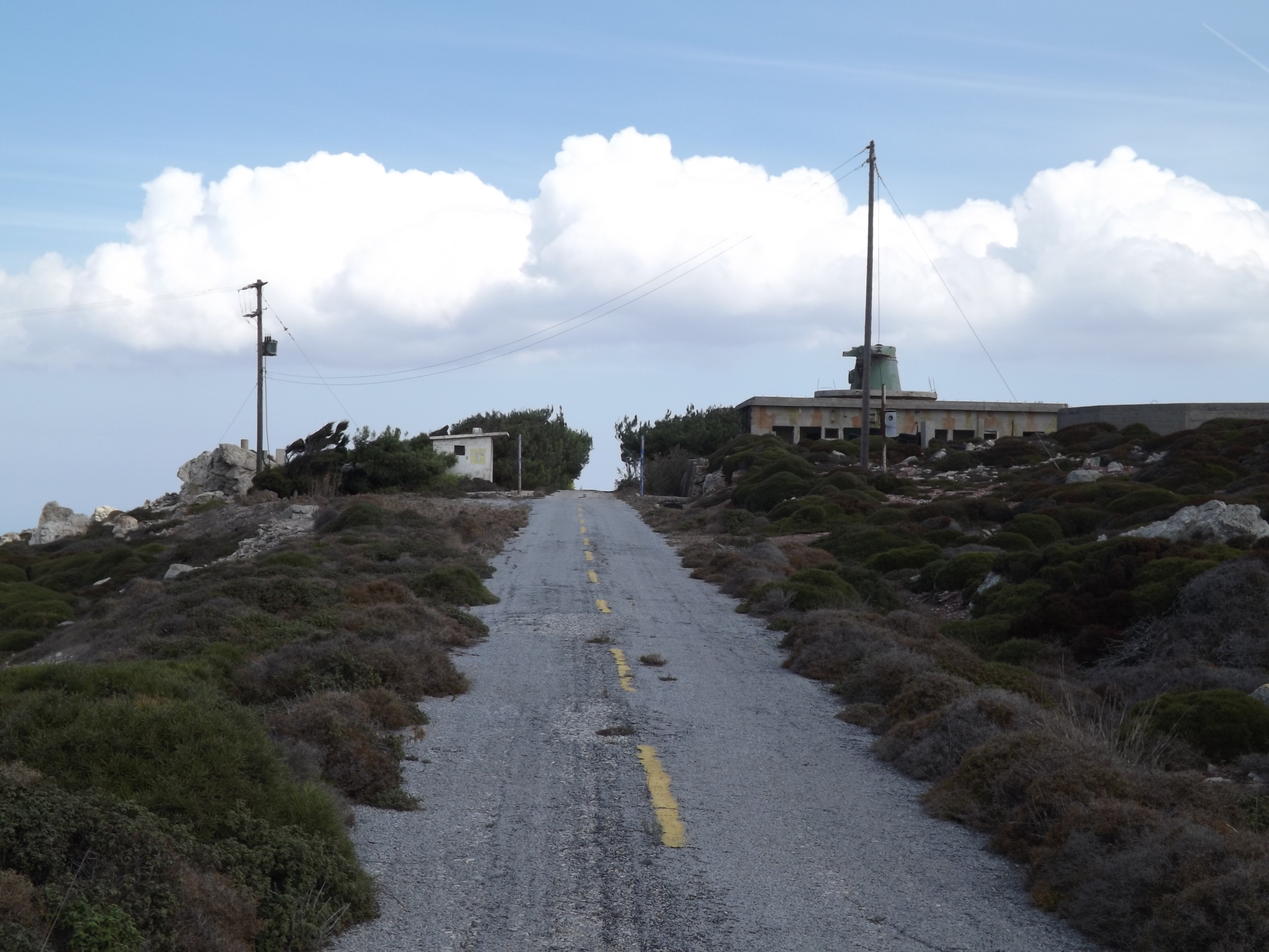
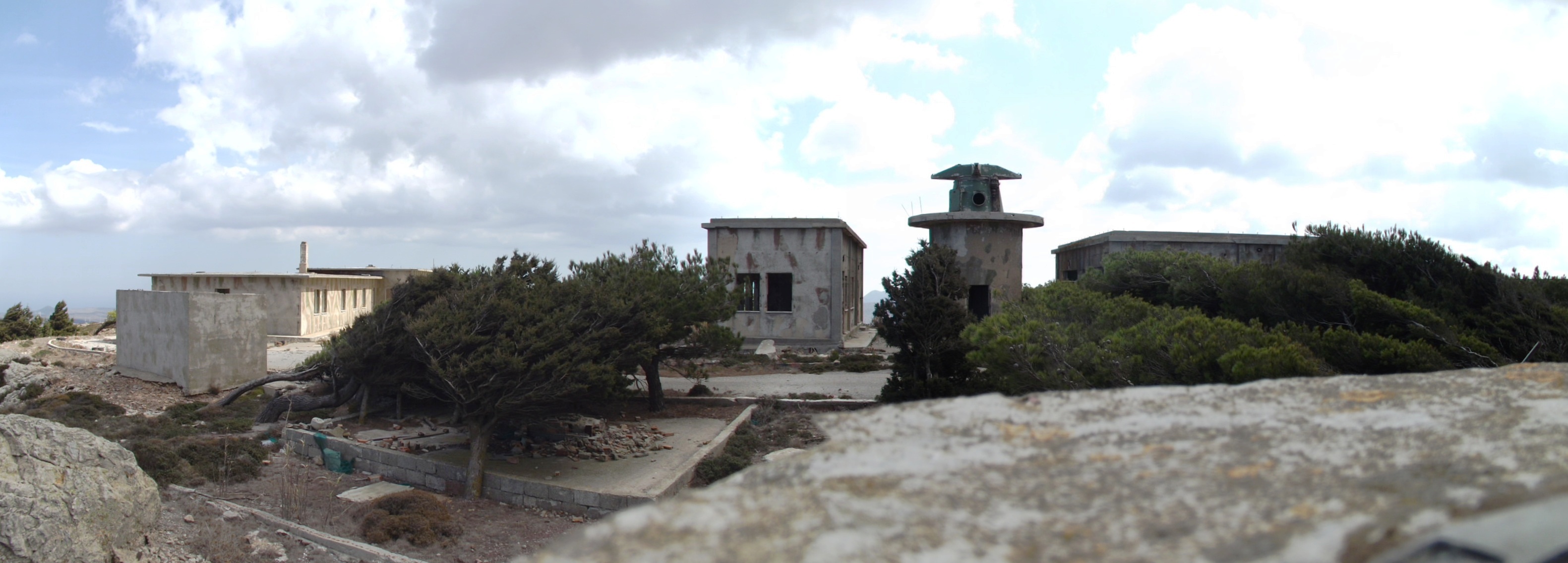
The Citadel: The wind was still stormy, but the sunbeams warmed me up. I embarked on the short struggle to climb the 3.5 kilometers and 200 meters in altitude from Mitato up to the „Citadel“, the ruins of the former radar station of the Greek Air Force on the summit of Mount Armi. Here the whole panorama of the plateau unveils its dreamlike beauty. The view stretches as far as Sitia and Mochlos in the west, the Kiriamadi peninsula in the north, the expanse of the sea in the east and the Ziros plain in the south.
Downhill To The North Coast: On the following 10.5 kilometers from the summit at 750 meters down to the coast, you pass by the village of Krioneri and ride through the grandiose mountain landscape. For 1.5 kilometers you face the stormy northwesterly wind. Then the road swings north for 5.5 kilometers, leading into the slipstream of the mountains and along the eastern slope of Mount Vothoni, then through the wind-protected valley. Just ahead of Roussa Ekklisia, you ride out onto the crest of the hill again and will have to keep your balance in the wind as the road winds down into the plain for another four kilometers until you reach the main road from Sitia to Paleokastro on the north coast.

Along The Coast To The Northeast: Turning right to the east and with the northwesterly wind at your back, you’ll virtually fly along for 8.5 kilometers. Riding parallel to the coast, the sprint takes you across two smaller hills each of which features a 50-meter climb (at Aghia Fotia and at the abandoned quarry in the big bend), then past the thrust fault of the Tripolitzakalk above the Violet Slate, and then east towards Paleokastro until you reach the branch to Toplou Monastery and the Kiriamadi peninsula.

Up To Moni Toplou: In eight wide bends, the road ascends for 3.5 kilometers from the late Miocene sands, marls and clays to the monastery of Toplou in the dry, barren and stony landscape of the Kiriamadi peninsula. The annual average rainfall here is less than 300 mm, and the vegetation is sparse, featuring the odd round and spiny shrub. The ascending road bypasses the Toplou Gorge eastwards and leads from the soft Miocene strata hundreds of millions of years back into the rocky desert of the Triassic and Permian slates, marbles, and limestones.

[Crete forms a horst (ridge) within a fore- arc- region of the northward subduction zone of the African Plate. In the Oligocene to Miocene, different layer complexes were pushed over each other as tectonic structures contrary to their time of origin, so that older layers came to lie above younger ones. There is a lower and a higher pile of thrust sheets. Parts of the lower pile, the Plattenkalk layers, the Phyllite-Quartzite-Unit and the Tripolitza layer, were deformed in the course of the alpine mountain formation and exposed to strong pressure which metamorphically altered the rock. In Eastern Crete, the Tripolitza thrust lies above the Phyllite-Quartzite-Unit and the latter above the Plattenkalk as the lowest tectonic unit].

Kiriamadi Peninsula: Opposite the lush green idyll of the Toplou Gorge with its spring, brooks and water puddles, an unadorned stone desert opens up to the north. In this magnificent solitude, you’ll virtually glide through a rocky desert between the sea and the sky at fast speed, while the narrow asphalted crest you ride on reaches far out to the border of the continent in the northeast, surrounded by the salty haze of the sea.

And if you then look back across the narrow connection of the islands to the south and all the way up to the Zakro Mountains rising up at the horizon, inhalating the shimmering air, then you will perceive scents of dried grass, limestone and marl, exotic woods, fruits, thyme, sage, and rosemary – that’s the scent of the Kiriamadi peninsula.

Coming from Toplou Monastery, you’ll reach the turn-off to Vai after seven kilometers (The total distance of the tour from the turning point Vai is 92 kilometers). The ancient city of Itanos follows in the direction of Cape Sideros. Shortly afterwards, you’ll reach the geological outcrop at Ermoupolis with the overthrust of the Tripolitza layer above the Phyllite-Quartzite-Unit, and, closer to Plakoures, the outcrop of Plattenkalk, the deepest tectonic unit of eastern Crete (The total distance of the tour from the turning point Plakoures is 106 km). On your way back through hilly terrain, you’ll arrive in Paleokastro after some 14 kilometers of speedy cycling.

Back To The Starting Point At Kato Zakros: From Paleokastro to Adravasti your route follows the fault zone of the Zakros Basin from north to south. Riding over a first hill and a small plateau you’ll proceed uphill through extensive olive groves inside the valley for about four kilometers and 150 meters in altitude. Winding its way through slate and limestone layers, the road passes small vegetable gardens, where fruit and almond trees line the path. The next stage takes you downhill again. Via Lagkada, you’ll get to the small village of Hohlakies. To the east, the impressive Hohlakies gorge is located behind the village of Kamara. You can take a three-kilometer (1.86-mile) hike/ climb through the gorge, all the way to the beach of Karoumes.
The route now takes a wide sweep to the west and proceeds uphill and downhill through the Violet Slate via Azkeramos, providing a steady ascent to Kellaria. In the west and south, the impressive Zakros Mountains with the Karidi plateau tower up. Their peaks are up to 700 meters high. On the steep flanks of the mountains, the road leads to the pass at the beautiful village of Adravasti. You will reach the pass after about eight kilometers and 250 meters in altitude. For another eleven kilometers you’ll go southeast past Klisidi and down to the coast at Kato Zakros via Epano Zakros.

A giant has come above the seas and moored his ship on the northwestern shore, he quickly approaches over the hills and the plateau with terrible wrath. Then he sees this crawling insect, nothing more than a fluttering ghost, drags and pushes him more and more, grabs him and kicks him down to the bloody floor. Ariel, windy spirit and lord of the storm, out of the inky sky, you sent pouring rain and thundering roar, as I fought my way up to the ruins high above the plain, the landscape was torn apart, by a Skylla hidden in swirling clouds, fortunately, I remained unscathed.