


10.4 Kato Zakros- Sitanos- Voila- Xerokambos- Kato Zakros | 70km | 1.522 Vertical meter | Category 3
70 km | 1.522 vertical meters | Category 3
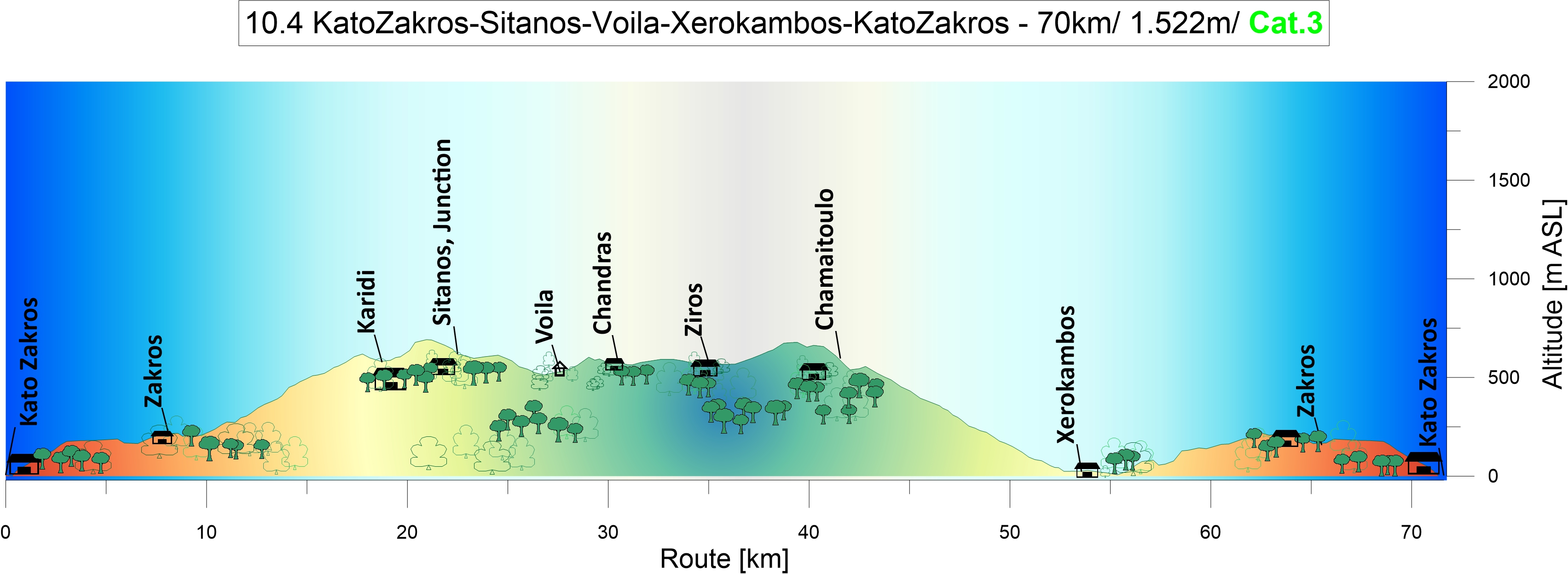
In a wind tunnel: The sun rises above Kato Zakros bay. While the valley is quiet, the wind blows strongly from the northwest across the crests and the passes. The first eight kilometres in western direction to Ano Zakros and the downhill to Xerokambos are easy going. But the climb up the wide sweeping bends to the Ziros Plateau became more strenuous than expected.

The headwind increases to six Beaufort. The guy on his bike pushes himself upward with his heart beating like mad. He travels light while he faces the breathtaking ascents up to the Plateau. Then he dashes downward into the next valley again and is but a small creature rushing along, tumbling into a sudden turn, just to encounter the next steep ascent. The climbing velocity is now on walking speed. Strong gusts drag at his body, trying to overwhelm him, then pushing him towards the abyss. It is sheer agony to climb against this strong and gusty headwind. The life has switched to slow motion. The bees take cover in the shelter from the wind provided by the climber and struggle their way over the pass to the next valley just like him.
So Harry from Nostros Restaurant at Kato Zakros, an ambitious climber himself, was right. “You put the cart before the horses – you have to ride the tour the other way round”


From Kato Zakros to Sitanos, Voila and Xerokambos: Two sweeping curves carry you high above the sea at Kato Zakros. A stop in the centre of the next village, Ano Zakros, to fill up the water bottles at the well. The actual karstic spring is located northwest of the village.
Leaving Adravasti behind, you follow the turnoff to the nine kilometre-long ascent to Karidi and the plateau of Ziros. In narrow hairpin bends with ascents of up to 12%, the road winds its way up towards the pass at 700m above sea level. The path is lined with limestone, marl, some violet slate, and the sparse vegetation of maccia.
Curve after curve, I climbed the steep ascent at high velocity. Then, loud and clear, a bicycle bell suddenly rings behind me. According to its sound, it belongs to an ancient Dutch ladies‘ bike. My only conclusion was: A woman on a Holland bike had caught up with me on a steep mountain road with a 10% ascent, and now she was about to overtake me. I’ve been humiliated many times in sports. Among other things, I was once overtaken by a young mother with a jogger stroller while I was running uphill. With tears in my eyes, I can still see her rocking ponytail disappearing ahead of me.

Nothing was lost, yet. Rising from the saddle and increasing the pace was one thing. I was now clearly spinning in the red zone. But the ringing continued, sometimes more to the left, then more to the right. Without a doubt, Jeannie Longo was at my rear wheel. Then it happened. I had briefly looked away, then the ringing suddenly came from the front. She had passed me. With a mild smile on her face – she stood at the roadside. A Cretan goat. Her bell rang merrily, and not just hers. There were bells ringing all around me, and the goats ran away as I stormed towards Karidi. I must have been a little out of my mind.


Passing through the village of Karidi which is embedded in purple slate, you climb the last 100 meters of altitude leading up to the pass. Then proceed further via the remote and abandoned elevated karstic landscape before the route takes you downhill to Sitanos, a farmer’s village in the fertile valley. Olives, wine, honey, vegetables and cereals have always been the riches of this area. In the centre of the village, turn left and head southwest following the road towards Voila and Chandras for five kilometres.
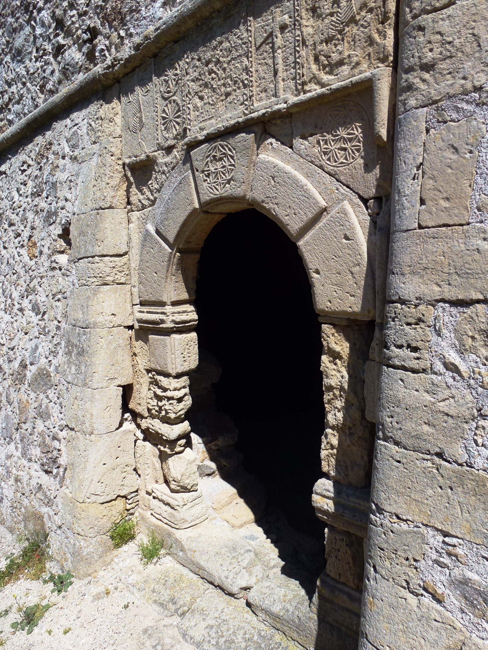
Voila: Just before you reach an S-curve, the sandy path on the left leads to the ruins of the medieval village of Voila, a mystical place with two refreshing fountains. A fountain with decorations from the Ottoman period and delicious, cold water is located right on the path. Shaded by almond, fig trees, oleander and a big cactus, the other one is situated above the private garden at the southeast end of the village.

The village is dominated by the massive residential tower of „Tzen Ali“. Probably of Venetian origin and dating from the 16th century, it was repaired and decorated during the Ottoman period in 1740-41. The archway shows decorations from this period. The tower served as a country estate for the utilisation of the fertile valley (Plateau of Armenochantradon) and as a base for the leaders of the Janissaries.
It ows its name to one of the most famous of them, Tzen Ali. In the surrounding village east of the path you can see residential houses, stables and storehouses, as well as the ruins of two churches. The well preserved two-nave church of Saint George situated on the eastern slope houses a 16th century gravestone fresco. To the west of the path, a protective wall, irrigation systems, and remains of buildings can be seen in the fields.

Follow the sandy path to the northwest and you will soon reach the peaceful farming village of Chandras. There is a small playground on the right side of the village entrance. Turn left here at the crossroads, pass by the highly recommendable village restaurant Taverna Katerina, then enjoy the descend and continue eastwards on the plateau towards Ziros, the administrative centre of the region. Because there was something to celebrate that day, someone fired a gun right over my head. The reader will understand that this incident had given me the necessary (adrenalin-based) acceleration I needed for the way south and up the pass (685m above sea level).
The descent to the Libyan Sea is one of the most beautiful in Europe. Featuring wide curves for 16 kms, the well-developed road takes you towards the glittering sea that displays its bright blue to turquoise shades along the way. The road is like an elaborate ribbon, like an ornamentation of the mountain rising up from the limestone and marl that is sparsely covered with maccia. It’s a party, a rush of speed on a technically challenging descent. Watch out in those hairpin bends, they can be very narrow and tricky in oncoming traffic. Xerokambos is a small and quiet coastal village. The houses are lined up along the coastal road, there are two mini-markets, a few taverns, and you can rent rooms or apartments. Special features include the fantastic white sandy beaches, the crystal clear water, and the small secluded coves where no other guests can be seen all day long.
From Xerokambos, the journey continues to Zakros. Following the fantastic descent down to the coast, the last 250 meters of altitude uphill to Zakros are easy to master before the last eight kilometres downhill to Kato Zakros close the circle.

Accomodation: Stella`s Traditional Apartements. About 700m from the beach. Well equipt ensuit Studios and apartements, run by the friendly Ailamaki family. Stella and her husband are globetrotters, mountaineers and himalayan hot shots who (not really) came to rest at this peaceful spot – Kato Zakros. For you it is a lay-back-atmosphere here in this paradisiacal resort with the shady garden and the genuine Greek hospitality. https://www.stelapts.com
Eating: Nostros Restaurant – Terrace at the waterfront. Very professionell and friendly run. Great eating. Fresh fish and grills. My favorite.