


8.0 Mirtos- Geraki- Kaminaki- Lassithi | 81 km | 2.479 Vertical meters | Hors catégorie
81 km | 2.479 vertical meters | Hors catégorie

But come, let me tell you now of the grief-laden homecoming that Zeus afflicted me with on my way back home from Troy.
From Ilion the wind drove me , brought me to the Kikones, to Ismaros. There I sacked the city, slaughtered the men.
From the city we took both the wives and a heap of gods and divided them.
I made sure none got less than a fair share.
Then I was all for us light-footing it out of there,
And so urged; but the rest, the great fools, refused to listen.
The much wine was drunk, and many a sheep they slew
along the shore, many crumple-horned shambling steers.
[Homer, The Odyssey ix, 39-46 – An New Translation By Peter Green]
Stormy Mirtos – For all those adventurers who appreciate a stormy day to start their journey, this would have been a good day – the waves of the Mediterranean Sea crashed against the promenade of the village Mirtos with a gruesome roar. The salty splashes and foamscraps even fly up to the 2nd floor of the hotel „Paradise„, located directly on the sea.

With unease, the skeptic in me gazed at the churning sea, while the squalls whistled and howled, rattling the windows, uprooting tables and benches on the promenade, driving torn tamarisk trees across the beach and enveloping everything in a murky, milky haze, whereby the small balcony, with a view on the sea, is covered by the spray of the storming waves.
But out of this din you hear a whisper, sending a holy shiver down your spine, a voice, the challenging call of the road: “Come on baby, step on the racetrack, this is your day! Feel the gray ribbon of asphalt speeding along under your wheels. It’s going to be a good ride, just you against the wind and God against us all“. An eerie tension takes hold of you and makes you shudder. You feel an inner turmoil that can only be soothed when the wheels touch the road and whirr along on the asphalt.
Perhaps you are the one who smiles, when your heartbeat widens the arteries on the never-ending climbs with a headwind of 8 BFT, when the quadriceps of your thigh and the calf muscles swell and cramp, painfully blocking every movement. Wild gusts grab you, hold you tight and try to push you off the road into the abyss. That’s not enough? Well, then Poseidon will be ordering a couple of heavy showers, which send you freezing on the slippery downhills.
Minoan Settlement Mirtos Fornou Korifi

On an island in the vast sea, fires blaze on the beach, illuminating the black, bulbous ships that were pulled out of the water, their heavy bodies resting on the sand like behemoths that rose from the sea. Sheep and goats are slaughtered, their thighs wrapped in fat, burned, and sacrificed to the gods. The helmsman mixes the wine and everyone drinks. This feast lasts for three days until a favorable wind reminds them to set sail. Provisions are carried onto the ships and Jars of wine and barley flour in sacks are stowed away under the oar benches. The spruce mast is erected, the stays and shrouds are attached to the wooden frames and the white sail is fastened to the boom. Grasping the cleats and pulling on two hawsers, the men push the ships into the water. There they lay and swayed slightly in the wind.

Mirtos Fornou Korifi – Waves rise from the great blue sea and rush onto the sands of the far shore. With tongues of foam, they hiss and roar between the rocks, shoot up the cliffs, only to tumble and gurgle back out of the stone basins into the sea. Trying not to be caught by the salty water, children are playing and collecting the conches of the surf zone into a bowl. Cooked with herbs and salt, the pointed conical limpet, keyhole limpet, or lamellated haliotis are delicious to eat in oil.
But suddenly their game freezes. From the small village high up on the marl cliff, dull drums and loud shouts can be heard. Driven by the wind, the dark smoke from a warning fire drifts to the north. It is a warning to all those who tend the sheep and goats, gather plants, draw water from the wells and cultivate the small gardens or the fields on the plain and in the valley.
The animals are driven to the north, towards the mountains, into the prepared hiding places. Everyone else hurries to the village. The women gather a few belongings in cloths and flee with the children towards the inaccessible heights in the north. Only a few old people remain behind.
Three white sails have appeared out of the haze above the horizon, stirring everyone on the two high towers and walls of the village fortifications. These are not the stolid, pot-bellied sailing ships of the merchants who trade dyed wool, woven blankets, and cloths for household goods and pottery, bronze weapons, sickles, and jewelry along the coast. No, these ships bring suffering and death.
Two hours remain to gather the weapons, arrows, and sling stones on the bastion wall and the towers to the south. At the main entrance to the village, the bastion with the tower, in the narrow lanes of the village as well as at the western rear entrance, the firmly fixed wooden gates are closed. The village is ready for defense.
Warriors armed with stabbing swords, shields and bows jump from the black ships onto the flat beach. They rush through the western valley and climb up the steep slope to the village.
There is a dull, hammer-like thud each time a sling stone hits an attacker’s head, while he raises his hands, he feels that his knees are going weak and he’s already falling to the ground. A hard thump when an arrow pierces the leather armor, stopping the running fighter and robbing him of the air to breathe. A scream, another cough, and he, too, wallows in the dust. There is a whirring of arrows, which soon cover the narrow alleys and roofs with their chert arrowheads. The defenders on the walls and bastions are only armed with slingshots and a few bows, which have little effect on the attackers, who approach quickly from the sides and run directly from the beach to the village.
The villagers are hit by well-aimed arrows, while the enemy has already taken the wall from the side and the west gate is forced open with axes. All those who can no longer flee are slain. On the roofs, the intruders run into the village, and as the sun sets above the sea the south bastion is reached and the gate is opened from the inside. The place is doomed. Looking for loot, the invaders ransack the village. They collect all metal objects, tools, weapons, and arrows, look for more provisions, drive the remaining cattle to the beach and smash everything that seems to be of no value. Wood is piled up and set on fire with bundled pine shavings, oil is poured in, and quickly the flames rise high.
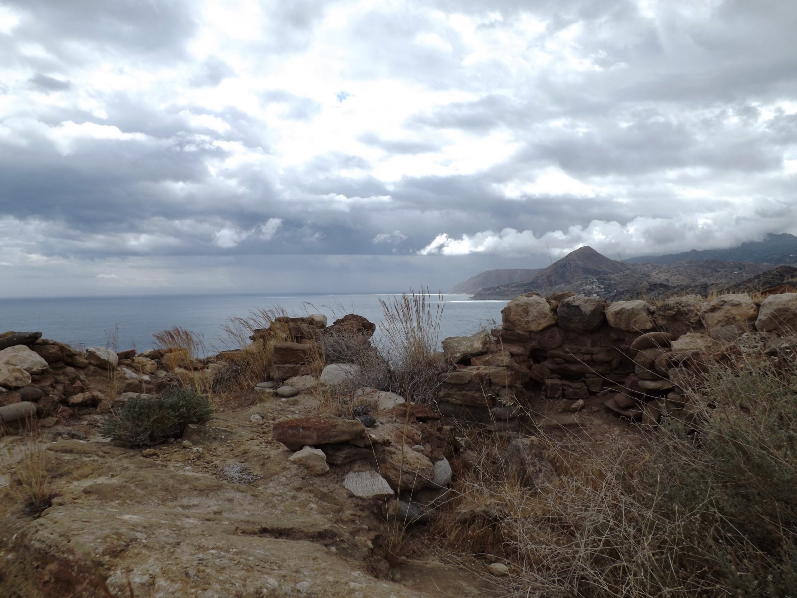
Defensive Site Mirtos Fornou Korifi

From 1967 to 1968, the English archaeologist Peter Warren excavated the village of Mirtos Fornou Korifi dating from the Early Bronze Age (EM II). He documented the architecture of the buildings and described the pottery and the finds illuminating the life and household activities of the villagers. About 3.6 km east of present-day Mirtos, the ancient village is located on a sea-facing, ca. 66 m high Pliocene cliff built up of marl, calcareous sandstone, conglomerate layers, and thin limestone beds. It can be reached directly from the coastal road to Ierapetra, which runs south of the excavation site.
The choice of the settlement site represents several considerations: the nearby sea as a transportation route, the possibility of defending the settlement from a steep hill surrounded by a wall, but also the utilization of two neighboring valleys to the east and west for agriculture and livestock farming, as well as for olive and vine cultivation. Assuming an overall wetter climate than today, groundwater wells provided a good water supply to the valleys. Across two settlement phases (EM IIA / EM IIB) from about 2,600 BC to 2,170 BC, the village existed for some 400 years.
Agriculture and livestock: Wheat and barley were cultivated, as well as grapes for winemaking and olives for nutritional oil production. Sheep were bred for wool production, so it can be concluded from the findings that the production of undyed and dyed wool, as well as garments, was a major gainful occupation of the village community. Goats were kept for dairy products, pigs for supplementary meat supplies, and the few cattle for tilling the fields. The plain directly north of the village, the land obtained by terracing the hill morphology, and the valleys (cattle breeding, arable farming) were used for agriculture. Fruits, nuts and herbs, wild vegetables such as wild cabbage, leaf spinach, dandelion, carrots, and sprouts were collected.
Architecture: The rooms of the individual houses were equipped with benches attached to the walls, horizontal workspaces, and platforms made of stone, stands for pots, crockery racks, and looms. Larger pottery workshops indicate that the pottery trade was another line of business. With the production of burnt lime for plaster and other purposes, water-bound mineral wall plasters and the stabilization of floors and ceilings could be achieved.

In the pottery industry, amphoras, pithoi, vases, jars, bowls, and jugs were made on hand-operated potter’s wheels. The production of sheep wool included sheep breeding, shearing, dyeing, and weaving. Beforehand, the wool had to be cleaned and washed, for example with the highly alkaline extract of the prickly saltwort plant, which grows abundantly in the neighboring valleys.
Water requirements: All these activities required water. Due to the geological situation with layers of marl, conglomerate, and sandstone, and with their large drainage catchment area extending into the mountains, the valleys to the west and east were able to store water as groundwater. These underground water reservoirs can be identified by the growth of vegetation and tapped by simple water well construction. The villagers will have brought the wool to the wells in the valley for washing and dyeing rather than carrying the amount of water needed for this purpose to the village.
Based on the required water quantities for the above-mentioned activities, it can be assumed that the climate was altogether more humid than today, as it is already documented for the period from 1938-1947, especially for 1944, 1945, and 1946. The mean annual rainfall here reaches a maximum of 728 mm (O. Rackham in „Myrtos in early Bronze Age Settlement in Crete,“ Peter Waren, 1972). Even though the runoff from seasonal heavy precipitation events has a lower seepage tendency into groundwater, it will have contributed to the groundwater input, especially in the coastal valleys, where lower gradients make for a longer retention time in depressions and valley incisions.
Social organization: Concerning the initial construction of the defense system, as well as food preparation, tool production, and the industrial production of wool and pottery by specialists, a differentiated social organization based on labor division is assumed for the EM II settlement Mirtos Fornou Korifi.

Mirtos Fornou Korifi was a small village where several families lived together in single households. Its estimated number of inhabitants ranges from up to 50 people (Krzysztof Nowicki) to up to 120 people (Peter Warren).
[The current village of Mirtos has a small museum situated at the center, in the old schoolhouse next to the church, with an amazing model of the Bronze Age EMII- site „Myrtos Fournou Korifi“. When looking at the highly detailed and scenic animated model, the everyday life of the villagers comes to life. The viewer immerses himself in this time, now more than 4000 years ago. Katerina Aspradaki- Skaramagas and John Atkinson did a great job of bringing the architecture, the organization and the daily activities of the villagers to life.] https://www.mirtoscrete.gr/the-museum-of-mirtos
Opening times: Monday 10:00 am to 02:00 pm, Wednesday 05:00 pm to 08:00 pm and Friday 10:00 am to 02:00 pm. For information contact Mr. John Atkinson Mobile: 6934116199; Home: 2842051143 as far as known and still valid.]
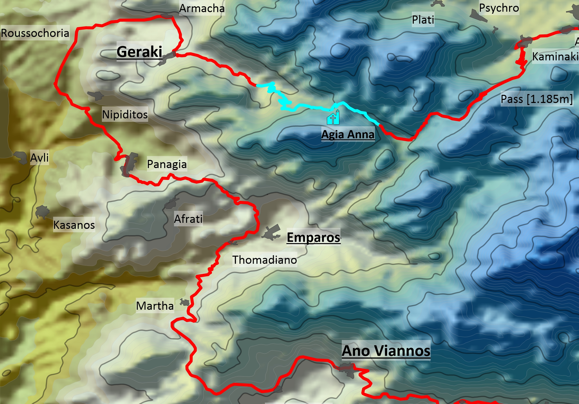
From Mirtos To Ano Vianos And Through The Iraklion Trench To Geraki


In wide curves, the road from Mirtos leads steeply uphill through the limestones, marls, and sandstones of the Pliocene to the first terrain level at 315 meters above sea level, where the village of Mournies welcomes you. Olive groves, oleanders, and low shrubs line the road, and a single Cretan cedar tree stands tall in the distance.
Featuring two more terrain levels at 430 (after 8 km) and 570 meters above sea level (after 11 km), this route proceeds past the abandoned village of Kalami, and leads you through marl and limestone until you reach the plateau at Pefkos at about 700 meters above sea level after a 14km- ride.
The village road is lined with shady poplars, fig trees, myrtles, plane trees, bright yellow weaver‘s broom and oleander bushes. Shortly afterward, an extensive stock of pine trees follows in the Pindos limestone area.
At Amiras, another heavy rainstorm briefly turns the road into a raging torrent. The road continues uphill through marl, slate, and phyllite until you reach the bare ridge after 20 km of cycling. From here, it’s just a 2.5-kilometer downhill ride on the „Old Road“ along the slopes of Mount Dikti to the picturesque district capital of Ano Vianos. Meanwhile, you’ll see a large bypass road below the town.
Situated at an altitude of 550 meters, Ano Vianos is a tranquil place that invites you to have a coffee at the large plane tree in the village center. The sun comes out briefly so that you can warm up a little. There is an ATM on the main road.

From Ano Vianos to the Iraklion Trench: For the next 20 kilometers, your route leads through the stony Phrygana and features two hills, each about 120 meters high. Due to the rainy haze, the steaming road is steeped in an intense scent of sage, while Cretan ebony bush and yellow broom gleam in the dusk.
Mastic shrub, kermes oak, cistus, and juniper flit by as you pass the villages of Martha, Thomadiano, Emparos, Afrati, and Panagia on your way to Nipiditos, where you descend through olive groves into the north-south running Iraklion Trench at about 310 meters above sea level.
Two kilometers behind the northbound turnoff to the village of Nipiditos and about 50 meters behind the small chapel (Xōkklḗsi), you turn right onto asphalt towards the villages of Armacha and Geraki.

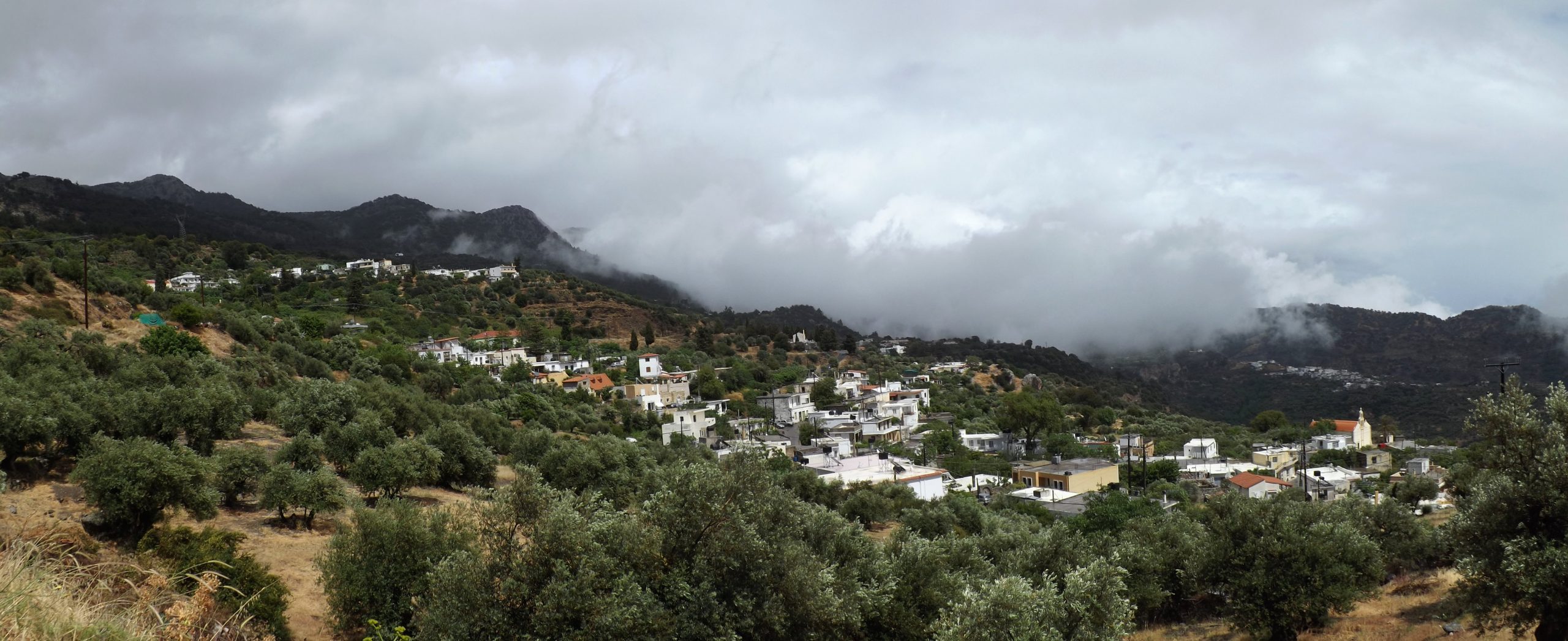
Geraki: Surrounded by olive groves, fields, and gardens, Geraki is situated at the foot of the Dikti Mountains at an altitude of 500 meters, „like a hawk sitting and looking at the plain“ (G. Saitakis).
A first village further to the southwest and mentioned as early as the 13th century, was destroyed during the Venetian rule. Founded in 1514 and built on this site, Geraki was presumably named after its first settlers.
The villagers make a living from agriculture in the fertile plain and the neighboring mountain slopes, as well as livestock farming. They grow crops like wheat and barley, vegetables, olives for nutritional oil, and grapes for wine, produce honey, and collect nuts. In the summer months, the flocks of sheep and goats are driven to the pastures of Mount Dikti.
On the ascent to the village, two aggressive dogs dashed out of the driveway of a goat shed and onto the road right in front of me. It actually took some targeted stone throws until they let me pass, but they kept on barking and pursued me in the pouring rain, all the way up to the village. Phew, that definitely got my adrenalin flowing.
From Geraki To The Lassithi Plateau
Geraki is an original Cretan mountain village. Its main street is lined with plane and fig trees, vines, and oleanders, and there is a minimarket in the village center. Twice a year, typical Cretan festivals are held here in honor of the local saints Agia Paraskevi (on July 26) and Michail Archangelos (on November 8).
Geraki is also famous for its locally produced cheese, which is offered to visitors at an annual cheese festival.
Water points in Geraki: I recommended that you refill your water bottles here for the remaining 20 kilometers to the Lassithi plateau. There is a water tap at the village entrance below the church and a spring at the village exit, where the road turns off to the northwest and Lassithi.
To get to the Lassithi plateau, turn left at the village entrance before you reach the church (there are two single houses on the left and right) and ride steeply uphill. After about 150 meters take a sharp left turn again and proceed through two hairpin bends for another 200 meters to get to the beginning of the road to Lassithi.
If you prefer a more comfortable route and wish to visit the village, ride uphill through the whole village in a south-western direction, take a sharp left turn at the village exit (the spring is on the left in the bend), and ride back in a northeastern direction above the village, past the small church Agia Anna on the right and straight on until you reach the beginning of the road up to the Lassithi plateau, which has some pleasant asphalted sections.

One more bend, and you’ll no longer be rattling away on an old worn-out village road full of cracks and holes but enter the enchanting world of the Dikti Mountains on a brand-new asphalt road built from 2014 to 2020, complete with flawless road markings and 30 km/h speed limit signs.
For a ragged biker like me, this unexpected change of scenery conjured up memories of a domestic Olympic Airways flight in a cool air-conditioned aircraft, where a lovely stewardess attended to the passengers in an off-the-shoulder dress and white kid gloves.

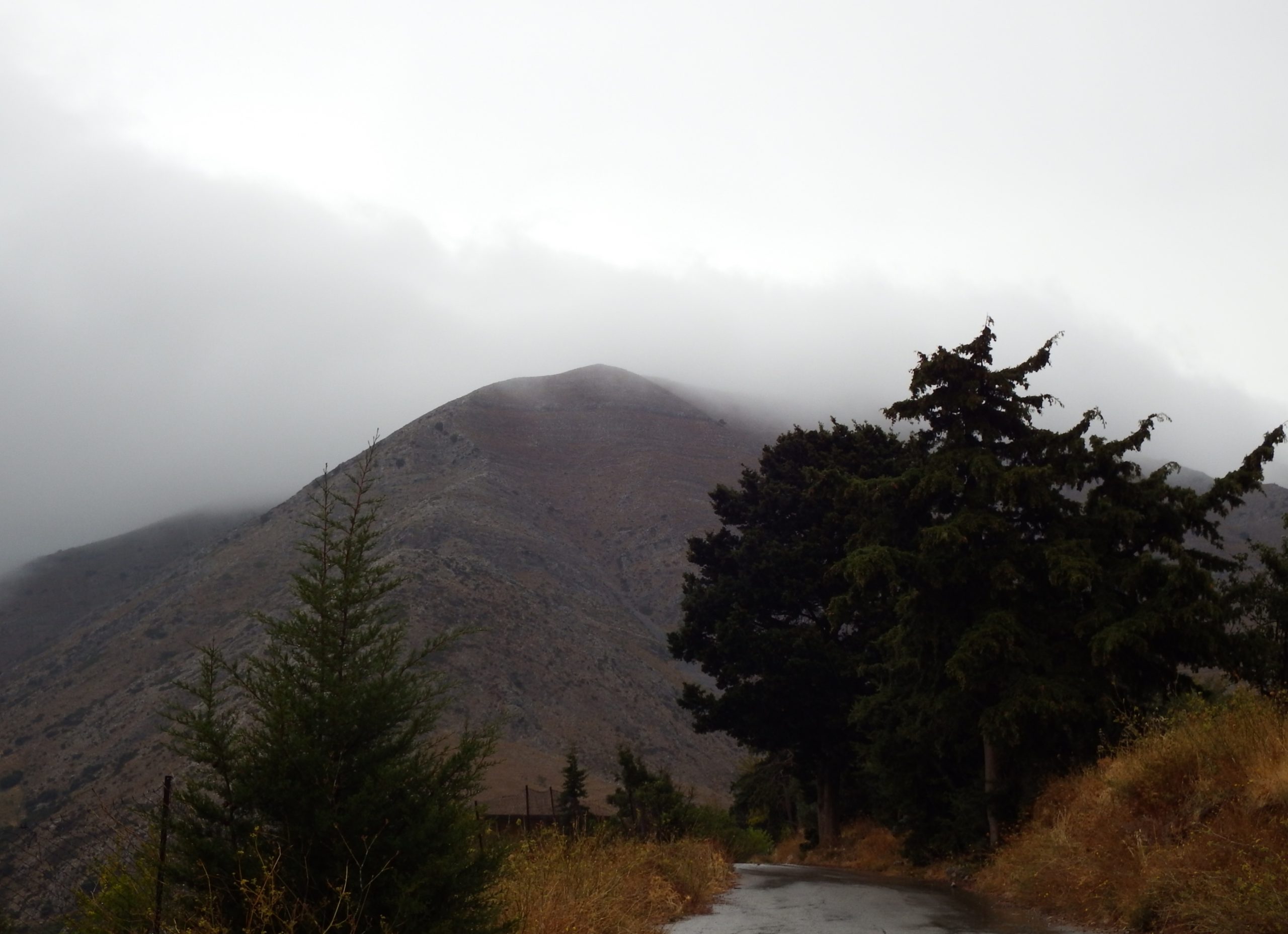
The Agia Anna chapel: With Mount Vourgiomeno, Mount Sarakino, and Mount Afendi as a backdrop, this dream road ascends at a moderate gradient of 4% for about three kilometers until the asphalt turns into a winding gravel path at the first steep valley spur.

For the next two kilometers, the road climbs steeply in narrow switchbacks, first at gradients of 8%, then 12%.
After another 2.5 kilometers at a gradient of 9%, you’ll reach the beautifully situated little Agia Anna chapel at an altitude of 1,000 meters. A spring provides deliciously fresh and cool water. On a small rock plateau, the church was built on the ruins of an older church around 1850 and is one of the most beautiful places to rest and reflect in this sublime landscape.
Coming from Geraki on the gravel road, you’ll cross the first pass at an altitude of 1,070 meters after eight kilometers, and reach the beginning of the completely asphalted road to the next pass and the Lassithi plateau after about ten kilometers.

A wide valley is crossed for two kilometers in a dreamlike, alpine mountain scenery with meadows of flowers, walnut, oak, carob and fruit trees now shining in the sunlight. Then the last ascent begins, leading you through a steep valley with limestone of the plattenkalk nappe and tripolitza nappe, up to the mountain ridge and its pass at an altitude of 1,185 m, delimiting the Lassithi plateau in the south .
On the flower meadow, leaves sway in the light breeze, stalks whisper, stretch towards the sky and asters gleam into the darkness. Mold, decay, putrefaction, honey-sweet a touch like flowers, this is the scent in the grass forest and above everything rises a hum, a hum of a thousand busy bees.
There, in the realm of shadows, a mouse is hiding, with a racing heartbeat carrying a hazelnut by its stalk. In a moment she will be safe under the big stone there. It’ll gnaw a small hole into the shell so its tiny tongue can reach the pulp.


A body falls steeply from the sky, briefly a shadow over the mouse and the claws of the kestrel pierce through the soft plum of its fur. One more scream and the mouse is carried aloft.
Above the pass, bearded vultures are circling in the updraft, and you can let your eyes wander all the way down to the plain, the surrounding mountains, and the narrow serpentines of the downhill road on which you’ll make your final 5-kilometer descent to the plateau and the village of Kaminaki.