


8.3 Mirtos- Orino- Chrysopigi- Sitia | 87km | 2.502 Vertical meter | Hors catégorie
87 km | 2.502 vertical meters | Hors catégorie

A black cat crossing your path signifies that the animal is going somewhere. [Groucho Marx]
A black cat scurried across the way. I followed the broken path of concrete, asphalt and sand that led steeply down to the lonely bay. After an enduring tour, I planned to complete my daily training in the mountains from there for another week.
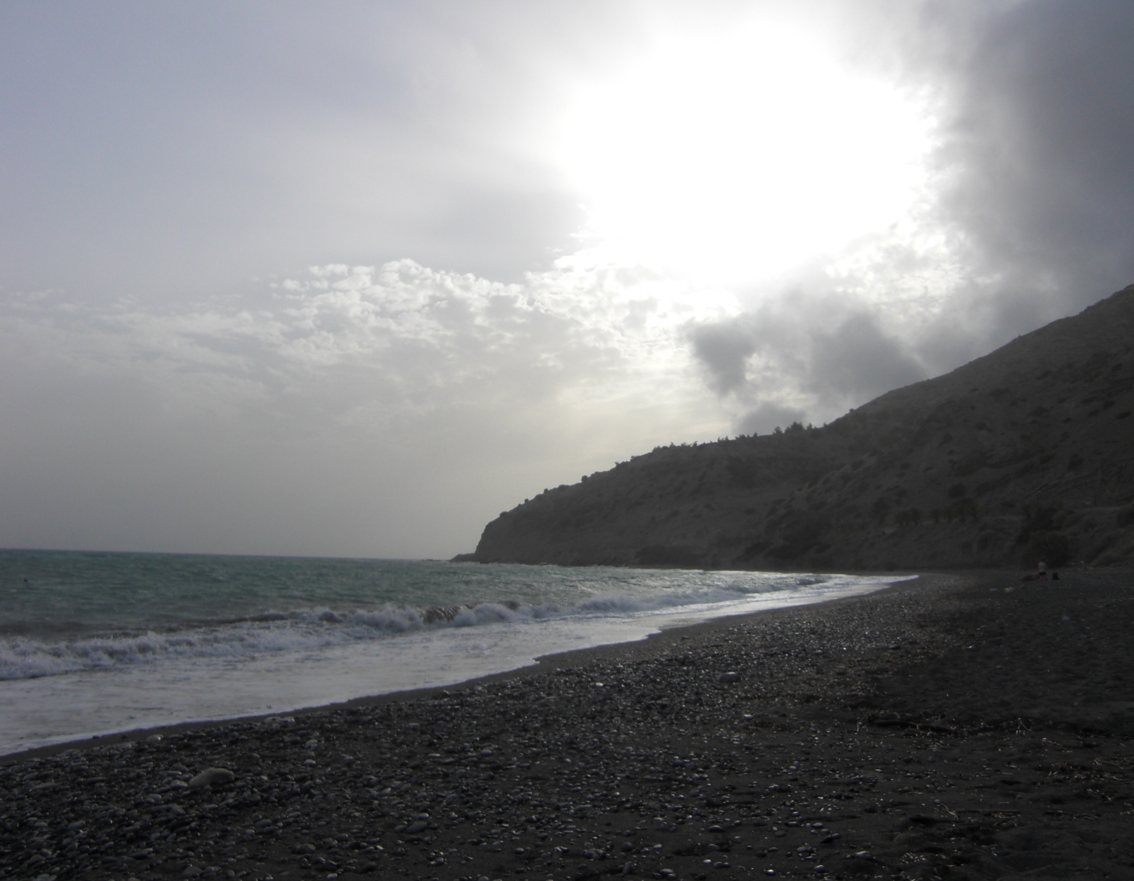
Perhaps the bay was a bit too lonely: At 5:00 p.m. the owner of the apartments sitting directly by the sea closed his small office and rushed away to a more urban realm. At 6:00 p.m. the few bathers left the beach. Spring had just begun, and the sun set at 8:00 p.m. At 9:00 p.m. it was dark, or rather pitch-black, because there was no further lighting in the bay. Only the windows of the small tavern, not much more than a snack bar, provided a bit of pale light until around 10:00 p.m. At incredible speed, and accompanied by the roar of engines, the last signs of life faded away.
I, the only guest, remained behind in the darkness. Like a remote little lighthouse, the lamps in my room sent out a beam of light to the sea and to the odd fishing boat, whose position lights slowly crept along the horizon.
On the second day, when I had just returned from training, I saw an unlikely couple sitting in the small tavern. They checked me out with piercing eyes that absorbed every detail – greedy glances from „killer eyes“ seemed to virtually undress me. I was worried because of their smeared make-up and that they were conspicuously prowling around my apartment.
On the first night in my lighthouse above the bay I had slept with the window and patio door open.
On the second day, however, I checked the lock of the entrance door, attached with just two tiny screws, as well as the locks of the window and the patio door. One kick, one push, even leaning against them was enough, and they flew open. That night, the window and doors remained completely closed.
On the third day the situation was unchanged, but that night I also pushed the bed in front of the room door to block it.
On the fourth day, the outrageous intentions of the killers and my own strategies mingled in my head. They had to be separated, disguised, and be kept secret from the other party, so that nothing became obvious to them. Obviously, I was going a little mental. The hundreds of kilometers and thousands of meters in altitude of the last week had left their mark.
On the fifth day I left the lonely bay where I was constantly in danger of mulling over such gloomy thoughts – thoughts that spun around in my head until they got out of control. I felt as if I was pulled into a maelstrom. It was like a mad ride on roaring merry-go-round, where faces are distorted to horrible masks, accompanied by increasingly shrill sounds.
I had to get out of this labyrinth and back to the starting point, preferably in a city. There I could drink my morning coffee in the hustle and bustle of a coffee house, and after the training I could choose one of the taverns lined up on the waterfront promenade. There would be a smell of roast kid, sage, thyme, garlic and wine – the glowing red wine of the Liatiko-Mandilaria, made from the grapes of the Ziros plain. In the evenings, I could enjoy the Vólta – a buzzing of engines, lyre sounds, shouts and chatter – and take in the yellow and white, red-roofed houses adorning the stairs and steep alleys crawling up the slope. The old fortress would tower above it all, and deep down in the harbor a ferry ship would elegantly detach itself from the quay. I needed a lively city whose pulse would take me back to normality – in one word: Sitia.

To Ierapetra: Built on the tertiary coastal terraces near the sea, the bustling main road heads east towards the plain around Ierapetra. On the left and right, tomatoes, cucumbers and bananas grow in the greenhouses scattered along the way.

Thanks to the prevailing tailwind from the northwest you will cover the 14 kilometers to sunny Ierapetra at a fast pace. Europe’s southernmost city, which enjoys the most hours of sunshine, is a lively coastal town and the commercial center of the area. Here you can buy everything from tools to agricultural machinery, including all supplies and spare parts. Even the small grocer, where I bought a rare dessert wine from the monastery of Toplou, offers great wines from the region around Lassithi and Sitia.
Follow the coastal road from Ierapetra for another ten kilometers further east, and then turn left at Koutsinari, where the route takes you into the mountains and to Agios Ioannis in the north.

Up to Aigos Ioannis: Now you’ll leave the Anthropocene behind and dive into the beautiful mountain world of the Thripti mountains. With gradients of 8%-10%, the first three kilometers provide a challenging warm-up session, while the remaining five kilometers to Agios Ioannis feature moderate gradients. Leading through the conglomerates and marls of the Agia Fotia formation, the road passes olive groves, pine trees and a few oaks as it majestically winds its way up from a wide valley. At the roadside, hundreds of beautiful yellow-brown lucerne flowers (medicago sativa) are in bloom.
In wide curves, the road proceeds through the bright marls and thin-banked limestone of the Sitia formation, followed by more conglomerates. Going further uphill until you reach the level of the Tripolitzakalk at about the level of the church of St. Anthony, you’ll soon see Agios Ioannis, nestled on a hilltop of limestone high above you.

Through the clean, white alleys of the village, its houses crowned with bougainvillea and tendrils of vine, you can walk up to the hilltop at 500 meters, where you can look far down into the valley and to the south coast between Koutsonari and Ferma.
In the old, abandoned stone houses time has stood still. Providing insight to the simple and modest life of its former inhabitants who resided here until about 100 years ago, they comprise a kitchen and bedroom, brick cornice, cupboard and open fireplace, as well as a small crawling cellar that you can access through a hatch. The cellar is lined with pithoi for storing supplies as it has been done thousands of years ago.
Ride through the village and a short way up to the pass to enjoy the most beautiful and varied landscape on a 10-kilometre descend via Schinokapsala until you reach the ascent to Orino.
As if visiting a chamber of curiosities, you gaze in amazement at the glitter and sparkle, the ever-changing artistry of the alpine mountain world. The tops of the Tripolitzakalk are shaped like faces and seem to lean down to speak to you. Between them, the clouds move quickly across the sky, casting their shadows on me and the winding road.
Over here, the rocks feature a soaring shear plane, over there you can spot a spring, a derelict water mill or a place of worship that invits you to linger, such as the single-nave Venetian chapel of St. George dating from the 17th century, located at the foot of Mount Afendis, to which one ascends through an enchanted forest of pines, sycamores and oaks.
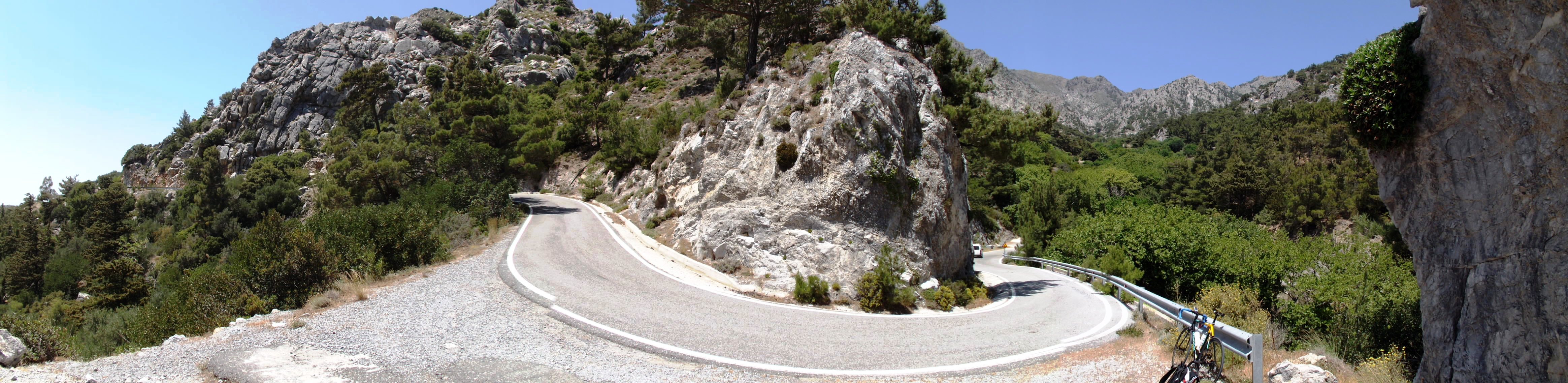
Orino – Go for the adventure: About 2.5 kilometers from Shinokapsala, turn left at the crossroads and cross the small hilltop to proceed uphill towards Orino. The increasingly steep mountain road now turns north and follows the western edge of the Orino Koutsouras Gorge (Koutsouras Communal Park).

The winding road to the pass above Orino does not allow for a breather. It is a mission for every climber on this grueling, steep ascent to climb the next slope, to climb the next bend, tirelessly keep your eyes fixed on the road immediately in front of you and start your powerful climb uphill – curve by curve, and from one ascent to the next, climbing uphill – feeling powerful, indefatigable, indestructible.
An average gradient of 8% and short, steep ramps of up to 18% make you feel as if you were fighting your way up a whitewater stream. Water rushes and gurgles downhill inside the large PE-HD water pipe laid on the side of the road. Make sure to fill your water bottles before you approach the ascent, otherwise you’ll constantly wish to drill this pipe to quench your terrible thirst.

Detour Butterfly Gorge: Two kilometers (1.2 miles) after you turn into the mountain road to Orino, there is a path branching off to the Butterfly Gorge. Why not make a slight detour of about one kilometer (0.6 miles) and descend to the gorge for a little excursion? Go downhill on the gravel road for 300 meters (0.2 miles), keep to the left at the Y-junction of the path and follow the narrowing trail up to the bend to the north.
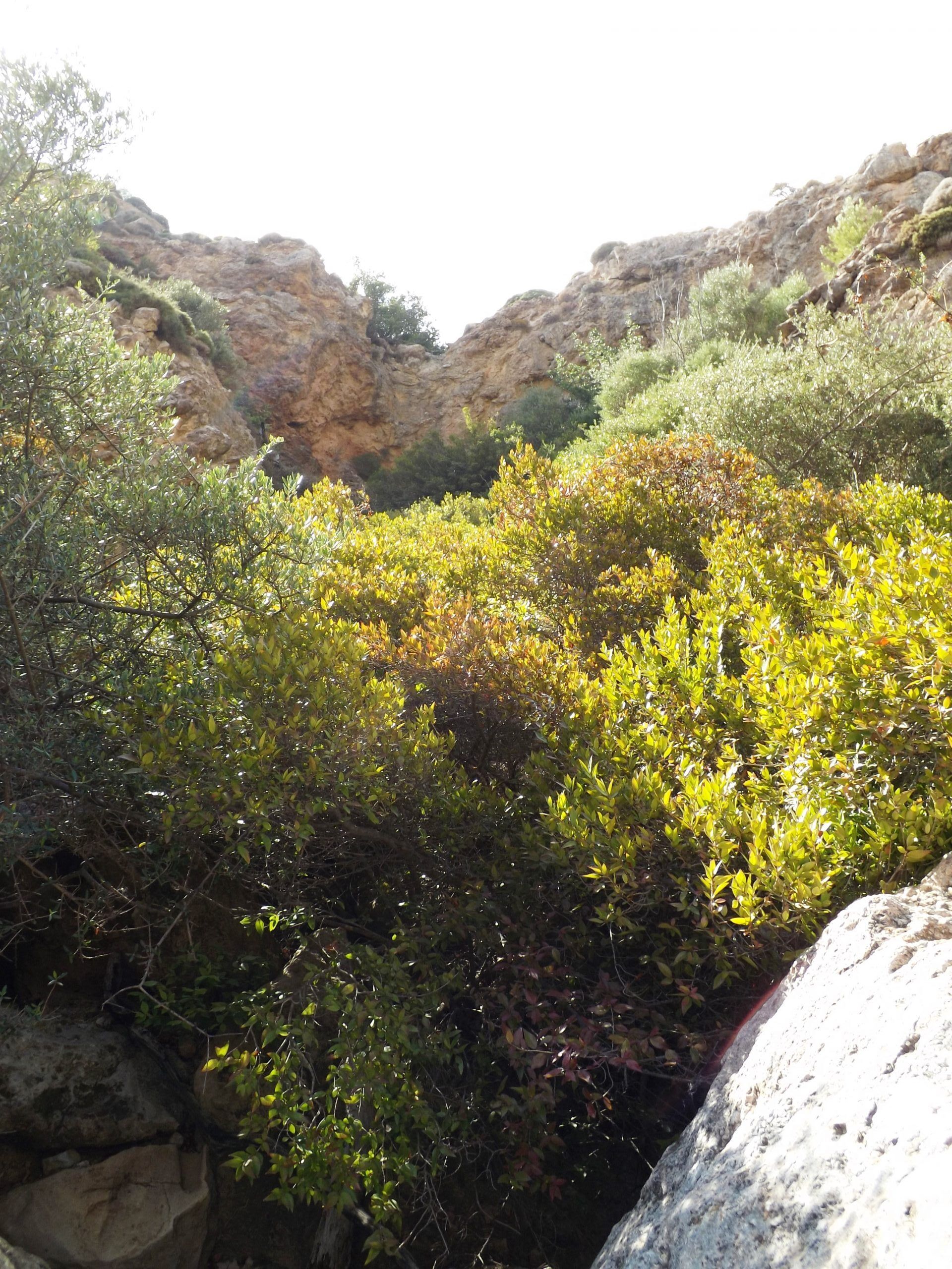
Parallel to the gorge, the hiking trail now goes relatively steep uphill again. There are some short passages where you’ll have to climb over stone ribs. After about 600 meters (0.4 miles) a path branches off to the right and into the gorge. Follow it to see one of the picturesquely situated waterfalls around here.
Sadly, the eponymous butterflies (Red Admiral or Vanessa atalanta) have largely disappeared, as the water of the waterfall. This is where they could be admired in large numbers more than 20 years ago.
At the branch of the regional road (keep left here) our route proceeds steeply uphill in narrow curves until we reach the village.


After a short break at the highly recommendable Kafenion, we climb from the village exit up to the pass, now heading east for about two kilometers. Stop to take in sweeping views of the gorge, the steep mountain road and Mount Afendis Stavromenos. Its peak up in the clouds, the mountain towers above the village, which is beautifully situated on the hillside and surrounded by olive trees, oaks and plane trees.
Downhill to Stavrochori: Next are three kilometers on a curvy asphalt road and your bike will swing downhill like a pendulum. Rushing through the soft valley shapes of the Tripolitzakalk, past juniper and pines, it traces the artistic course of the road and scurries along the ribbon that is the street, like the needle of a barograph. The vegetation of thorn cushion plants around here includes colorful splashes of yellow spiny mullein (verbascum spinosum), tree spurge (euphorbia dendroides), wild carrots (daucus carota) with white blossoms, and flowering orchid. Some crocuses also greet you with their bright colors.
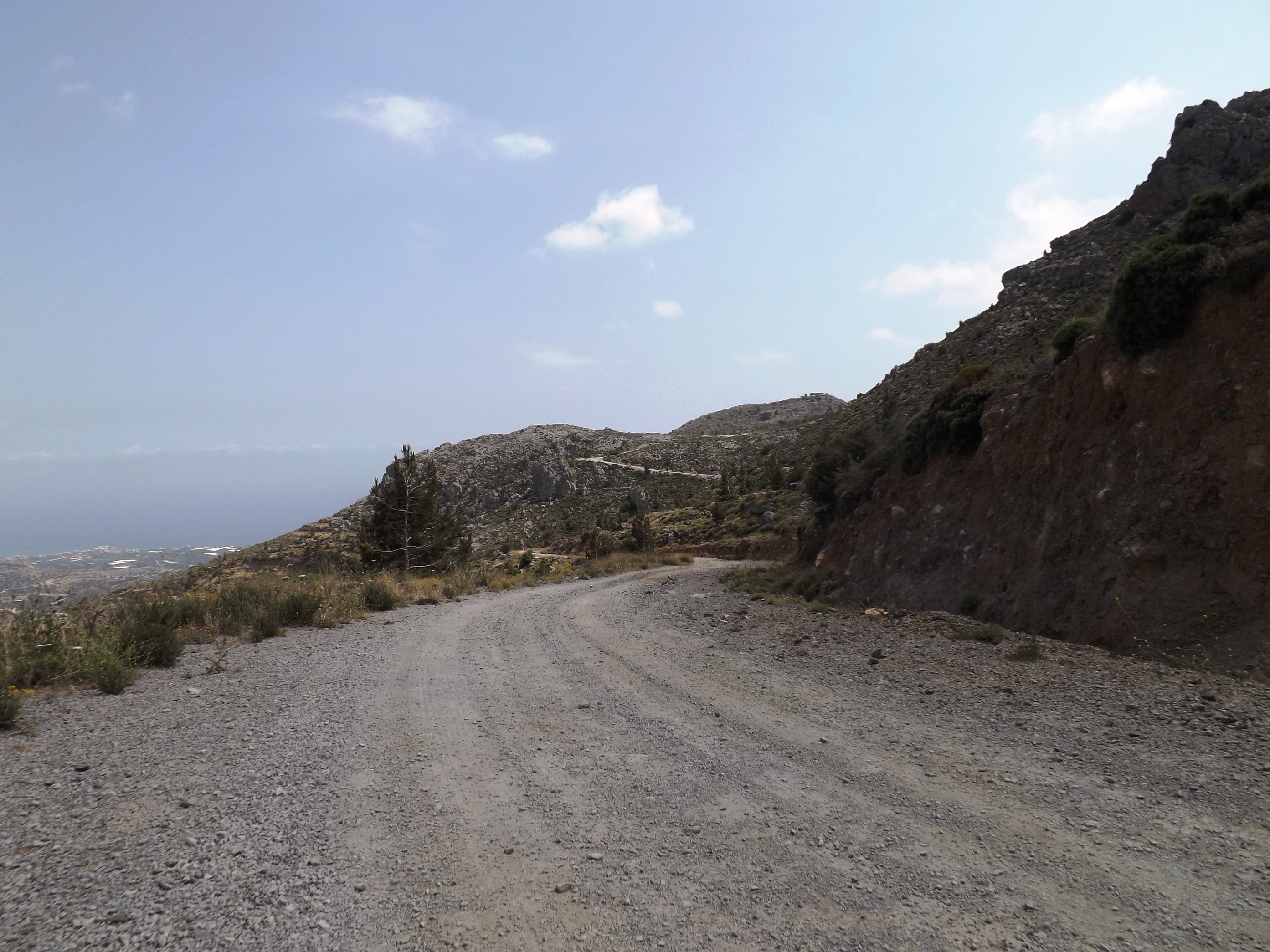
Leading down to Stavrochori, the asphalt road then turns into a gravel road for about three kilometers. This part of the gravel track from Orino to Stavrochori is certainly not suitable for racing tires, but you can easily ride on it when using Cyclecross tires. Their road bike version, up to a width of 31 mm (1.22 in), is the perfect tyre for this tough job. There are a few eroded stretches where you have to get off your bike and push it for a short while. I recommend you carry a pair of light sports shoes in your backpack, so that you can comfortably stretch your legs for a while. Long cycling shorts, a fleece shirt, a wind vest and rain jacket are also recommended for the weather conditions and low temperatures in the mountains.

Soon you will see Stavrochori in the valley below you, surrounded by olive groves, and its houses arranged around the large two-aisled church in the center. The alleys are adorned with white and purple bougainvilla, and the inviting tavern on the platia is shaded by plane trees. Step inside and take a break, while the hospitable landlady will look after you in the old Cretan tradition.
Sitia: We leave Stavrochori to the east and enjoy another 1-kilometer downhill ride before the varied ascent to the pass begins near of the village of Lapithos. The ascent actually features two passes. The first part of the route leads along the south-eastern slope of the Orno Oros mountain range with its Plattenkalk (platy limestone) rocks.
We proceed via Chrysopigi, which means we will cover 500 meters in altitude. At a moderate gradient, we will then ride uphill and downhill through the green valleys of marl and limestone with their shiny white, embedded gypsum cliffs. And yet, we are going constantly uphill on this 12-kilometer route, until we cross the pass at 640 meters in altitude.

The landscape between Sita, Chrysopigi, Stavrochori and the south coast as well as on the route back to Sitia via Makrigialos, Lithines, Epano Episkopi and Piskokefalo provides a perfect training environment for cyclists. You hardly encounter any cars in the mountains, the gradients are moderate, and the long, hilly passages are perfect for fast rides and sprints. So nowadays, you will meet other cyclists more often, mainly from Sitia and the tourist hotspots along the eastern south coast around Koutsouras and Makriguialos.

Sitia is a small, tranquil harbour town that has retained its Cretan character. Restaurants and cafes line the coastal promenade. Head to the south-eastern part of the harbour to find some excellent eateries. Cretan snails with rosemary in olive oil and wine as well as the fish specialities are highly recommended, along with wine from the monastery of Toplou. In the evening, when people stroll in to party and have dinner, the tranquility transforms into a lively buzz.
Accomodation: Itanos – Platia Iróon Polytehniou. Sober hotel atmosphere, centrally located on the main square, rooms predominantly featuring sea and city views.